




The US National Hurricane Center’s latest forecast, for what remains tropical depression nine at this time, is for the developing system to become tropical storm Isaias later today, after which it is forecast to intensify into a hurricane and head towards a landfall on the Gulf Coast.
Update – 09:00 UTC: Tropical storm Isaias has now been named as the depression intensified and the NHC said just now, “Maximum sustained winds have increased to near 40 mph (65 km/h) with higher gusts. Rapid strengthening is forecast over the next day or two, and Isaias is expected to become a hurricane by Thursday.”
The latest forecast advisory data now shows hurricane Isaias reaching wind speeds of around 90-95 knots, which would still be Category 2 although a little stronger than the previous forecast with potential sustained winds of close to 110 mph at its currently forecast peak. Some weakening is forecast prior to landfall, but meaningful uncertainty for all the reasons laid out below remains.
Update – 15:00 UTC: The NHC’s latest information on tropical storm Isaias puts the storm with 45 mph and higher gusts, but still “Rapid strengthening is forecast over the next day or two, and Isaias is expected to become a hurricane by Thursday.”
With this latest update the NHC has also provided storm surge forecasts for as high as 7 feet between Ocean Springs, MS to Indian Pass, FL and Mobile Bay, AL, with lower surge heights along the adjacent Gulf coastline. Hurricane conditions are expected to begin on the coast from late Friday, with tropical storm conditions earlier that day. On the rainfall front, 3 to 6 inches is expected with localised amounts as high as 10 inches as Isaias passes through. The forecast advisory data still shows sustained winds of up to 95 knots as hurricane Isaias approaches landfall, so that forecast has not changed in the last few hours.
This tropical depression has been watched all week and almost every meteorologist we follow had initially assumed that hostile conditions and wind shear would prevent it developing into a particularly significant storm for the insurance, reinsurance and insurance-linked securities market.
But conditions have become more conducive and now what will become tropical storm Isaias is seen as having the potential to intensify into a Category 2 hurricane, before making landfall somewhere on the Gulf Coast, with the NHC’s forecast cone stretching from central Louisiana through to the western Florida Panhandle.
Significant uncertainty remains, as dry air and wind shear will continue to be factors that affect Isaias’ ability to strengthen.
But meteorologists are now saying that the more quickly eventual tropical storm Isaias can intensify into hurricane Isaias, the greater the chances of a more impactful and damaging landfall event. How long it spends over warm Gulf waters could also factor into its intensity, alongside the levels of dry air and shear it encounters.
The latest NHC forecast cone shows a hurricane Isaias at landfall, with the forecast advisory data suggesting a low Category 2 event with sustained winds of up to 100 mph.
Model forecast tracks seem to be centred on a landfall somewhere to the east of New Orleans at this time, but how strong Isaias becomes, how rapidly it moves forwards and how soon it turns north could change any location for impact at this time.
The chart below from Tomer Burg’s PolarWx service shows the current NHC forecast including cone and wind speeds:
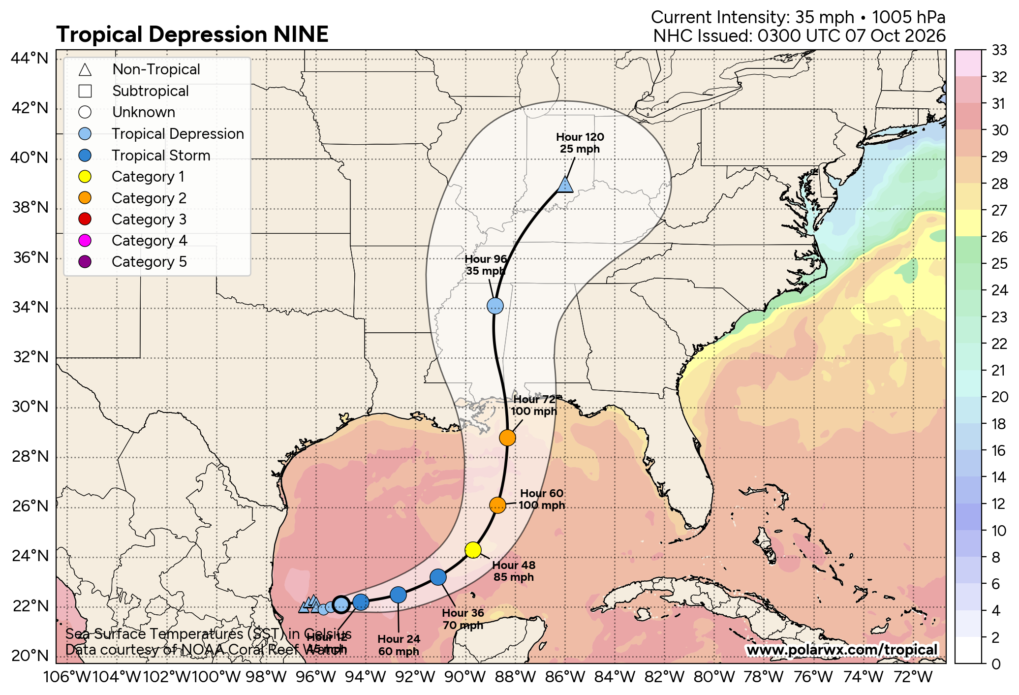
There remains meaningful uncertainty, as what will become Isaias is forecast to travel over very warm Gulf waters, with plenty of fuel for intensification, but it will continue to battle with dry air and wind shear as it approaches land and the timing of a turn to the north is also less clear, although how much this will all hinder it (as we said) depends on how quickly the storm can organise.
The NHC explained, “At 1000 PM CDT (0300 UTC), the center of Tropical Depression Nine was located near latitude 22.1 North, longitude 95.0 West. The depression is moving toward the east near 5 mph (7 km/h). An east-northwestward motion is expected on Wednesday, followed by a turn toward the northeast and north on Thursday and Friday. On the
forecast track, the depression is expected to pass to the north of the Yucatan Peninsula on Thursday and approach the U.S. northern Gulf Coast on Friday.
“Maximum sustained winds are near 35 mph (55 km/h) with higher gusts. Steady strengthening is forecast, and the depression is expected to become a tropical storm early Wednesday and a hurricane on Thursday.”
The NHC also stated, “High oceanic heat content, moist mid-levels, and upper-level divergence should allow the compact system to intensify during the next few days. The only limiting factor appears to be southwesterly vertical wind shear, which is forecast to strengthen later this week as the system approaches the northern Gulf Coast. Most skillful models show the system becoming a hurricane over the central Gulf, and the latest forecast shows a similar rate of intensification and peak intensity as the prior forecast, generally following the more aggressive Google DeepMind and HCCA aids. Due to strong shear, it is likely that the system peaks in strength before reaching the coast as a hurricane. The cyclone is also expected to grow in size as it approaches the northern Gulf Coast, and the anticipated convective and motion asymmetries will likely cause rain and wind impacts to extend far from the center on the eastern side of the storm.”
Andrew Siffert, BMS Group Senior Meteorologist, provided some helpful commentary on the outlook for a potential hurricane Isaias in the Gulf in a post on LinkedIn, saying, “Things have escalated quickly in the Bay of Campeche. Warm Gulf waters, high ocean heat content, and a brief favorable upper-level window will now allow TD 9 (Isaias) to intensify rapidly over the next 36 hours. I, for one, didn’t see this coming that quickly. This means Isaias has more time to get going and a major hurricane before Thursday afternoon is possible—but I don’t see this as “Milton 2.0.”
“The question is how much dry air and increasing wind shear weaken Isaias before landfall, which at this point looks to be near Gulfport, Mississippi. The exact track and intensity remain uncertain.
“The NHC forecast calls for a Category 2 landfall, but a strong storm may not weaken quickly, which is why it is critical to see just how strong Isaias gets over the next 36 hours. I have already mentioned the warm SST, but I haven’t mentioned that it’s not just the sea surface temperatures; it’s the deep-ocean heat content Isaias will tap over the next 60 hours, which will help fuel its intensity, and rapid intensification can’t be ruled out.
“Dry air and shear could leave Isaias lopsided—a “half-a-cane” with impacts concentrated east of the center, as seen in several past storms.
“That east-weighted structure is one reason not to focus on the centerline alone. Surge risk is still uncertain. A stronger, larger storm would raise concern along the vulnerable coast from New Orleans to Pensacola. The Florida Panhandle is already saturated from recent rainfall. Isaias may move quickly and produce limited rain in some areas, but rainfall ahead of landfall remains a concern with already saturated ground. A significant, potentially prolonged tornado threat is also possible east of the track, including after landfall. The location depends on where Isaias comes ashore.
“Bottom line: the forecast remains complex. Hurricane hunter data over the next 24 hours should help clarify how strong Isaias becomes, and this maximum strength over the Gulf will help us understand how much it weakens before landfall.”
It’s far too early to forecast any specific impacts for the insurance, reinsurance, catastrophe bond and insurance-linked securities (ILS) markets, but this developing storm Isaias is the first true threat of the 2026 Atlantic hurricane season and so will be watched closely over the coming hours.
A Category 2 strength hurricane Isaias landfall, as the forecast currently suggests, would typically not be an event of note for catastrophe bonds, but would certainly have ramifications for insurance coverage and potentially for some reinsurance arrangements, perhaps including private ILS.
This storm shows that even when hurricane forecast numbers are light and the season absent of threats so far, it only takes conditions to become more conducive for a relatively short time for a threat to emerge.
We’ll update you as the situation develops and you can keep track of developments using our 2026 Atlantic hurricane season page.
 View all of our Artemis Live video interviews and subscribe to our podcast.
All of our Artemis Live insurance-linked securities (ILS), catastrophe bonds and reinsurance video content and video interviews can be accessed online.
Our Artemis Live podcast can be subscribed to using the typical podcast services providers, including Apple, Google, Spotify and more.