




Isaiais is now the first hurricane of the 2026 Atlantic season having intensified overnight and the forecast continues to suggest a Category 2 landfall on the Gulf Coast is a possible outcome, at which level of intensity reinsurance broker Gallagher Re said it would typically result in insured losses in the low to mid-single digit billions.
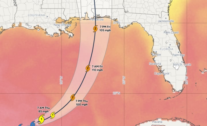 Hurricane Isaias was upgraded from a tropical storm overnight and at the latest 06:00 UTC update on October 8th the National Hurricane Center (NHC) puts Isaias as a Category 1 hurricane with sustained winds of 75 mph and higher gusts, with minimum central pressure of 981 mb. It’s said Isaias is the latest first hurricane of a season to form in over 100 years.
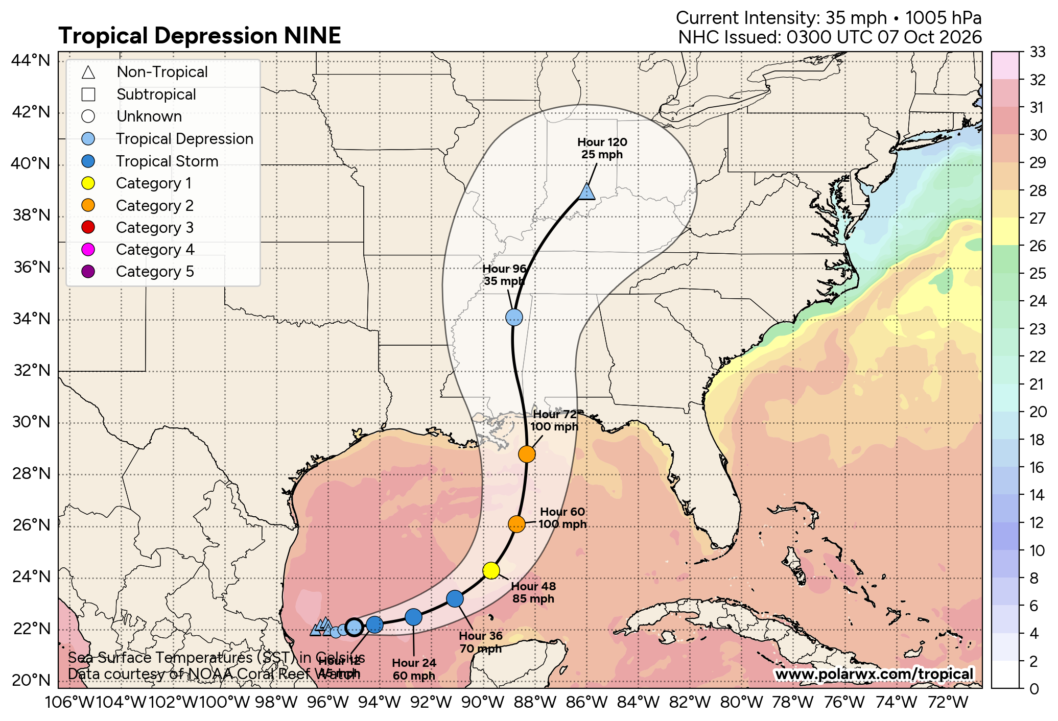
Hurricane Isaias is expected to strengthen, although from satellite imagery it still looks a little lop-sided this morning, with a passage to the north of the Yucatan Peninsula of Mexico expected, after which the storm is forecast to begin to turn northeast and then north towards the US Gulf Coast.
The timing of that turn continues to have uncertainty in it, meaning the landfall location remains harder to know at this time, but the forecast cone has moved generally east, with eventual land impact expected between Mississippi and the Florida Panhandle still. Currently the centre line of the forecast cone is just into Florida.
The chart below from Tomer Burg’s PolarWx service shows the current NHC forecast including cone and wind speeds (this should update to show the latest hurricane information shortly):
Impacts from hurricane Isaias will be more widely felt than just the cone, with high rainfall levels expected more broadly along the Gulf Coast, as well as inland along hurricane Isaias’ track after it makes landfall and there are warnings of tornado potential with this storm as well.
The NHC forecast advisory data continues to suggest hurricane Isaias will reach Category 2 strength, with maximum sustained wind speeds approaching 100-110 mph and higher gusts, but it is also currently expected to begin weakening slightly as it approaches landfall.
With the Gulf waters very warm and still elements of dry air and wind shear in the region, there remains a lot of uncertainty over just how intense hurricane Isaias could get, as well as how much it could weaken before landfall, or even if it weakens at all. We may need another day to pass to have a better understanding of that.
The NHC stated in its recent update, “On the forecast track, Isaias is expected to pass to the north of the Yucatan Peninsula later today and make landfall along the U.S. northern Gulf Coast within the warning area late Friday or early Saturday.
“Aircraft data indicate that maximum sustained winds are near 75 mph (120 km/h) with higher gusts. Additional strengthening is expected through early Friday, and Isaias should remain a strong hurricane as it approaches the northern Gulf Coast on Friday night.”
Storm surge heights of up to 7 foot are still anticipated, as well as rainfall totals as high as 10 inches, as hurricane Isaias makes landfall and moves inland.
Landfall is still anticipated to be very late Friday into early Saturday at this time, although a longer passage and curve in the Gulf could delay Isaias, or a more direct path accelerate it.
Reinsurance broker Gallagher Re has provided some helpful loss context, which is valuable for those in the insurance, reinsurance, catastrophe bond and insurance-linked securities community.
“At this early stage, there remains ample uncertainty of where Isaias may ultimately make landfall and at what intensity.
“However, assessing current exposure along the north-central Gulf Coast and analyzing historical storm landfalls in the Category 1 to Category 2 range in this part of the United States suggests insured losses (including private insurance carrier and National Flood Insurance Program gross claims payouts) reaching into the low to mid-single digit billions (USD).
“The overall economic cost, including underinsured or uninsured losses, would then likely tally a few billion (USD) higher.
“Losses at this level would likely be driven by a combination of wind damage, storm surge inundation, inland flooding, and tornado touchdowns commonly found in the outer bands of tropical systems, with the final industry loss highly sensitive to the storm’s track, size, forward speed, and impact duration.
“Given ample reinsurance market capital, this event is unlikely to meaningfully affect upcoming reinsurance renewal discussions for January 1,” Gallagher Re explained.
Gallagher Re also stated, “Recent Category 1 storms making landfall along the northern Gulf Coast have generated insured losses ranging from several hundred million dollars to the low-single digit billions (USD). Category 2 and Category 3 landfalls have generally resulted in materially greater insured losses, averaging into the low- to mid-single digit billions (in today’s dollars), particularly when surge impacts, prolonged power outages, or widespread inland flooding accompanied the event. The historical record also demonstrates that relatively small changes in landfall intensity or track can produce significant differences in ultimate loss outcomes due to varying exposure concentrations across coastal Louisiana, Mississippi, Alabama, and the Florida Panhandle.”
In addition, Isacco Loconte, an insurance-linked securities (ILS) Investment Specialist at asset manager Azimut Switzerland SA, has also posted some thoughts on hurricane Isaias on LinkedIn.
Loconte said that there are stochastic events that imply higher loss levels for the insurance and reinsurance market, over the $10 billion level, but those events are few and considered outliers, with the vast majority of stochastic events similar to Isaias resulting in an industry loss of less than $5 billion.
Loconte said that the most similar stochastic event in the set was 1995’s hurricane Opal, a storm that weakened to a low Category 3 at landfall and drove an estimated industry loss of around $7.4 billion.
But that is a stronger storm than hurricane Isaias is currently forecast to become, so the sub-$5 billion industry loss seems more reasonable if Isaias can only reach low Category 2 wind speeds.
Loconte also said that there has been some activity in the catastrophe bond secondary market, with offers emerging on a number of hurricane exposed catastrophe bonds thought to be more at-risk from Isaias. He noted that, “However, none are at distressed pricing, and there is currently no confirmation of any executed trades.”
We heard similar from sources yesterday, but as Isaias moves nearer to land through today, if it stays on its forecast intensity curve, then we’d imagine little will actually trade, as a sub-$5 billion hurricane industry loss would not typically be anticipated to pose a threat to the vast majority of cat bonds, being in the main calibrated to provide their reinsurance protection for more significant loss events.
Certain collateralized reinsurance or private insurance-linked securities contracts can always be exposed to any hurricane landfall, while aggregate reinsurance and retrocession structures can of course experience deductible erosion from any billion dollar plus industry loss event.
There are potentially going to be some parametric insurance contracts in hurricane Isaias’ cone, but again we’d anticipate the majority of these being calibrated to respond to a more intense storm, or a larger loss than something in the low to mid-single digit billions of dollars. However, there could always be some loss activity in that market, if Isaias does not begin to weaken on approach to land as is currently forecast and naturally depending on landfall location and wind speed hitting parametric triggers.
The market is going to need to continue watching hurricane Isaias closely, as how quickly it can intensify today could be critical in determining how impactful a landfall event it eventually becomes.
Early loss forecasts are often prone to error, so how many billions of dollars Isaias eventually costs remains to be seen, but the latest forecast does seem to align with the early predictions for a low to mid-single digit billion industry event.
However, should Isaias encounter conditions less conducive to further intensification, a less impactful event is also still possible. Again, it should become clearer later today when we see how strong hurricane Isaias can become.
We’ll update you as the situation develops and you can keep track of developments using our 2026 Atlantic hurricane season page.
 View all of our Artemis Live video interviews and subscribe to our podcast.
All of our Artemis Live insurance-linked securities (ILS), catastrophe bonds and reinsurance video content and video interviews can be accessed online.
Our Artemis Live podcast can be subscribed to using the typical podcast services providers, including Apple, Google, Spotify and more.