




Hurricane Polo is rapidly intensifying off the southwestern coast of Mexico and the strengthening trend is expected to continue, while the track remains uncertain at this time, which has brought the $175 million IBRD CAR Mexico 2024 (Pacific) parametric catastrophe bond into focus this week.
Note: This article was first published at 08:00 UTC on September 22nd, you can find our updates further down this page.
Polo quickly moved from depression, to tropical storm, to hurricane and now to major hurricane with currently Category 4 sustained winds estimated at 130 mph and higher gusts.
Meteorologists seem to anticipate major hurricane Polo reaching Category 5 status in the coming hours, as it moves over extremely warm waters off the southwestern coast of Mexico.
With the still strengthening El Nino in effect in the Pacific, the waters off the coast of Mexico are plenty warm enough to sustain a very strong hurricane at this time and conditions have seen the region light up with multiple tropical systems in recent days, with a chance of more to come.
Currently, most forecast models suggest major hurricane Polo won’t make landfall immediately, but may track further north west and eventually perhaps make landfall around the Baja peninsula.
However, the current location of hurricane Polo is close to the Mexican coastline and any wobble in the path as the storm moves forwards could bring it much closer to the coastline and the parametric box of the catastrophe bond, which runs just off the shore.
You can see the current location of hurricane Polo and its forecast path below, in this graphic of the NHC forecast from Tomer Burg:
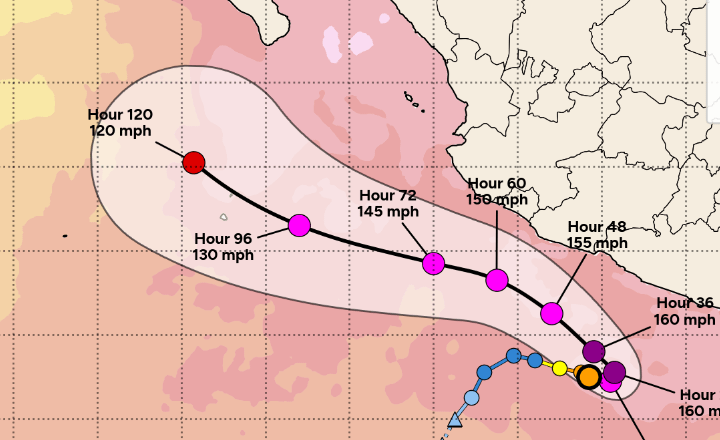
As you can see, hurricane Polo is forecast to move parallel to the Mexico southern coast as it tracks west, with the current position showing an abrupt turn and there being some uncertainty over how sharp that turn will be.
Any deviation closer to the coastline of Mexico could take hurricane Polo very near to the IBRD Mexico 2024 catastrophe bond’s parametric trigger box arrangement, which runs up the coastline. So there is some uncertainty, perhaps sufficient to consider the cat bond on-watch for now.
Further down the forecast path for hurricane Polo, numerous model runs also show the storm curving back towards the Mexican coast, with others bringing a landfall on the Baja peninsula.
You can see the model uncertainty in the graphic below from Tomer Burg:
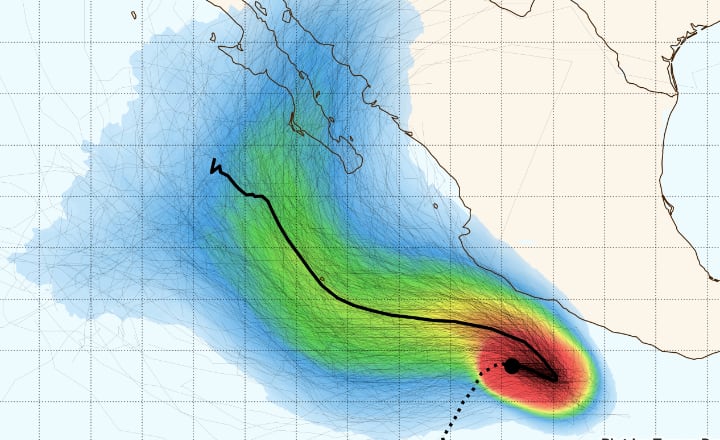
Each of the lines on the graphic above represents a model run for hurricane Polo, with numerous showing a potential landfall and a good number showing the potential for the storm to get close enough to the Mexican coastline to breach the parametric trigger box design.
The $175 million of IBRD CAR Mexico 2024 (Pacific) parametric catastrophe bond notes feature a parametric trigger design that requires a storm to have a minimum central pressure at or below specific levels in order to trigger a payout if it moves across the parametric box.
Different areas of coastline have different payout factors attached to them as well, so location and intensity are the two key metrics for defining whether any payout will occur and those payouts can be from 25% of principal, right up to the full 100% or $175 million, depending on where any hurricane breaches the parametric box.
There is meaningful uncertainty still at this time, due to the fact hurricane Polo will turn and move back towards the northwest along the Mexican coast, but any shift closer to the coastline could bring the catastrophe bond’s parametric box arrangement into the storms path.
At the same time there is uncertainty further out, in how and when hurricane Polo may turn back towards Mexico, as well as in how intense the hurricane actually is at that time, so how low its minimum central pressure is. There’s also uncertainty in how Polo may interact with other storms, such as Odalys and a yet to develop system that some forecast models show following a similar path in the coming days.
Hurricane Polo would need to continue intensifying and deepen its central pressure to get close to becoming a triggering event for Mexico’s catastrophe bond though.
The latest NHC update estimates the central pressure at 955mb, where as for the cat bond to be triggered a storm must pass the parametric box with central pressure at 937mb or lower, we understand.
As a result, while the threat is there with hurricane Polo, at this time we need to see the situation develop further, in terms of the storm’s track and intensity for the cat bond to really be threatened.
Helpfully, Isacco Loconte, an insurance-linked securities (ILS) Investment Specialist at asset manager Azimut Switzerland SA, posted his thoughts on hurricane Polo on LinkedIn yesterday.
Loconte said that running 1,000 members of Google WeatherLab’s r2 ensemble model shows 77 scenarios where the Mexico Pacific hurricane catastrophe bond is triggered, with potential losses ranging from the 25% all the way up to the full 100% of principal.
Loconte also noted that he had seen some price adjustments in secondary market offers for the cat bond, which might suggest a heightened perception of risk at this time due to hurricane Polo.
Loconte also stated, “Polo is a perfect reminder that high reactivity is an intrinsic feature of parametric Cat Bonds. While the market values these structures for their rapid, transparent payouts compared to the lengthy loss-adjustment process of traditional indemnity bonds, that exact same sensitivity applies to live events. The moment a storm approaches the box, the risk profile – and consequently the secondary pricing – shifts instantly.”
Update – Loconte provided us some fresh information based on the latest model runs:
Looking at the latest Google WeatherLab r2 run, the number of scenarios impacting the Cat Bond is down to just 22.
The maximum loss has dropped from 100% to 75%, while the mean loss remains steady at around 45%.
The key driver behind this shift is the ensemble trajectory: it tracks further offshore, with most members missing the West Coast entirely before making landfall in Baja California.
Update 2 – The NHC has updated hurricane Polo to a Category 5 storm, with a minimum central pressure estimated at 926mb. That would be sufficiently low to trigger the Mexico IBRD cat bond, however the forecast path for Polo remains far enough offshore at this time not to take the storm closer to the parametric trigger boundaries, although some uncertainty still remains over the future path.
Update 1, Sept 23rd 07:00 UTC – Overnight, hurricane Polo’s central pressure deepened to as low as 892mb, more than low enough to activate the trigger of this cat bond had it come close to crossing the parametric boxes. But the storm remained offshore of Mexico and that is where it is situated this morning, with central pressure now estimated slightly higher at 905mb (still below the triggering point for the cat bond).
However, Polo’s forecast path remains predicted to stay offshore while at its most intense and a growing number of model ensemble members keep it that way for longer now. There is still a potential turn towards the Baja peninsula to consider over the coming days, although that is expected to be as a weakening hurricane whose central pressure would be rising. So, at this stage, the risk to Mexico’s IBRD cat bond does seem meaningfully reduced compared to the situation 24 to 36 hours ago.
Update 2, Sept 23rd 15:00 UTC – Hurricane Polo remains a strong storm with 150mph sustained winds, but its minimum central pressure has risen higher, to a currently estimated 927mb. Forecasts still suggest it will remain sufficiently offshore to avoid the parametric trigger layout of Mexico’s IBRD cat bond, while a landfall on the Baja peninsula early next week is also still deemed possible. At that time, forecast models suggest Polo will remain a hurricane, but be weakened, still suggesting minimal risk to the cat bond from any future landfall, although this storm will likely need to be watched if that landfall remains in the forecast in case of any re-intensification occurring.
Update 1, Sept 24th 08:00 UTC – This morning, the latest NHC information on hurricane Polo shows a slight re-intensification to 160mph sustained winds and a minimum central pressure of 923mb. The forecast cone suggests Polo will still remain offshore until a later turn into the Baja peninsula on Monday afternoon or evening Mexico time. The forecast advisory data suggests maximum sustained winds will fall to between 100mph and 130mph by that time of landfall being made, which still suggests a weakened hurricane with a higher central pressure, likely above the levels needed to trigger Mexico’s parametric Pacific named storm catastrophe bond.
Update 2, Sept 24th 16:00 UTC -Hurricane Polo continues to be a large and dangerous storm, with sustained winds of 155mph and a minimum central pressure now slightly higher at 927mb, as of the latest NHC update. The forecast path for hurricane Polo continues to take it to landfall on the Baja peninsula of Mexico on Monday as a weakened but still likely damaging and impactful lower category storm.
Our market sources continue to anticipate that with the weakening on turning towards the Baja peninsula, the minimum central pressure of hurricane Polo will be expected to be higher and likely above the levels required for Mexico’s parametric cat bond to be triggered.
Update 1, Sept 25th 06:00 UTC – Hurricane Polo maintains sustained winds of 150 mph and higher gusts and continues on a curving track towards a forecasted Baja peninsula landfall on Monday evening. The minimum central pressure of the storm has risen slightly to 935mb as of the latest NHC estimate.
Some re-intensification is expected today, with hurricane Polo thought likely to regain category 5 status which may deepen the central pressure somewhat. But, the NHC’s forecast advisory data still suggests Polo will weaken, with the forecast suggesting a hurricane with 110 mph winds will make landfall, which is likely to drive a higher pressure still and so avoid the Mexico parametric cat bond trigger point. Still some uncertainty remains and if Polo could sustain its intensity for longer, then the market may need to take a closer look at the storm data by Monday.
Update 2, Sept 25th 13:00 UTC – Hurricane Polo has intensified meaningfully again, with the latest NHC update estimating sustained winds of 180 mph and a minimum central pressure of 908mb, so deeper again. Still, the forecast remains for Polo to begin weakening over the weekend and make landfall on the Baja peninsula with winds somewhere below 110 mph at the time. The market expects this is likely to result in a rising central pressure when weakening begins and a triggering of Mexico’s cat bond continues to be seen as an unlikely outcome from hurricane Polo, although some uncertainty does remain this far out from landfall.
Over the course of this week bid/ask spreads for the Mexico IBRD Pacific coast named storm cat bond have widened with the uncertainty surrounding its path and fluctuations in intensity.
Update 1, Sept 27th 14:00 UTC – Hurricane Polo remains a major storm with sustained winds of 120 mph, but its minimum central pressure has been rising and now stands at an estimated 952mb. With landfall on the Baja peninsula still forecast for Monday, the outlook suggests pressure will continue rising as intensity decreases over the coming hours. It remains likely this will not trigger Mexico’s parametric IBRD catastrophe bond, with the pressure needing to be now considerably lower for that to happen.
Update 1, Sept 28th 09:00 UTC – Hurricane Polo continues to have maximum sustained winds of 120 mph as it approaches the Baja peninsula of Mexico. Minimum central pressure is estimated at 954mb by the NHC. While hurricane Polo is expected to be at or near major Category 3 strength on landfall, for Mexico’s parametric Pacific named storm catastrophe bond to be triggered it would require the central pressure to fall to 937mb or lower, which at this stage continues to be deemed unlikely to occur.
However, while the cat bond is designed to protect Mexico’s finances against and provide disaster risk financing for more severe events, hurricane Polo is still expected to be an impactful storm for the region where it makes landfall and the NHC warns of life-threatening winds and flash flooding.
At this time (on September 22nd), should hurricane Polo follow the NHC cone forecast, it does not appear that the catastrophe bond could be triggered, it would remain offshore while at its most intense and if it turns into Baja it would be as a weaker storm, likely with higher pressure and so unable to activate the parametric trigger.
But things can change and the uncertainty surrounding Polo’s expected turn makes it a storm to keep an eye on today.
We’ll update you should the threat to the Mexico Pacific coast hurricane catastrophe bond change for the worse, as the hurricane Polo situation develops.
 View all of our Artemis Live video interviews and subscribe to our podcast.
All of our Artemis Live insurance-linked securities (ILS), catastrophe bonds and reinsurance video content and video interviews can be accessed online.
Our Artemis Live podcast can be subscribed to using the typical podcast services providers, including Apple, Google, Spotify and more.