




Hurricane Simon in the Pacific remains a very strong storm at major hurricane strength and is expected to sustain that status when it makes landfall on the Mexico coastline on Sunday, with its intensification and deeper pressure now putting the $175 million IBRD CAR Mexico 2024 (Pacific) parametric catastrophe bond at potential risk.
Update – Oct 11th, 09:00 UTC: Hurricane Simon is still a very Category 4 storm with sustained winds of now 155 mph and higher gusts estimated around 170 mph.
Overnight, the minimum central pressure of hurricane Simon was estimated to have dropped to 928mb, but at the 09:00 UTC update this morning it is now slightly higher again at 930mb.
That is now at a low enough level where Mexico’s $175 million tranche of IBRD CAR Mexico 2024 (Pacific) parametric catastrophe bond notes are thought likely to face a triggering event and a 25% payout, should Simon cross the parametric trigger box line with pressure of 932mb or lower.
It’s important to note, it remains highly uncertain at this time whether a triggering event will occur for the cat bond, or whether Simon will weaken and its pressure rise above the attachment level required by the parametric box.
The NHC stated, “At 300 AM CST (0900 UTC), the eye of Hurricane Simon was located by satellite imagery near latitude 18.7 North, longitude 105.2 West. Simon is moving toward the north-northwest near 6 mph (9 km/h), and this general motion is expected to continue over the next day or two. On the forecast track, Simon is expected to be near or just inland over west-central Mexico later today and move very close to the coast on Monday.
“Maximum sustained winds are near 155 mph (250 km/h) with higher gusts. Simon is a category 4 hurricane on the Saffir-Simpson Hurricane Wind Scale. While some slight weakening could occur, Simon is still forecast to move near or over the coast of west-central Mexico as a major hurricane today.”
As we’ve reported and you can see more on this by going through the original article and updates below, we understood from sources that a pressure of 932mb or lower may be the required threshold for a triggering event to occur in relation to Mexico’s catastrophe bond.
At this time, Simon seems to still be heading towards the same parametric box that information was sourced for, which is positioned along the coastline of the western Mexican state of Jalisco.
That 932mb or lower pressure level could activate a 25% payout of the cat bonds $175 million of principal, while a pressure of 915mb or lower would be required for it to reach 50%, we are told. We believe payouts increase linearly with declining pressure between those points, meaning any percentage over the initial 25% payout threshold is possible at pressures between 932mb and 915mb, up to 50%, when Simon crosses the parametric box in its path.
Weakening is still anticipated as hurricane Simon draws up to the Mexico coast, which means it remains uncertain whether the cat bond will actually face a triggering event and partial loss, or not. As said before, it is the minimum central pressure reported in the Automated Tropical Cyclone Forecast (ATCF) b-deck data, which is the official data source for the parametric trigger calculation.
An analysis seen by Artemis shows Simon’s latest forecast advisory data suggesting that Simon’s pressure may rise a little above the 932mb triggering level by the time it actually enters the parametric box. But, it is such a close run thing that at this stage it may need that to occur and then the data be analysed again, based on the b-deck statistics when they are available (typically within a few hours), to know the outcome for the cat bond for certain.
Update – Oct 11th, 00:00 UTC: Hurricane Simon is drifting slowly towards the Mexican coastline, with the NHC still putting maximum sustained winds at 150 mph and the minimum central pressure at 932mb.
Some weakening is still anticipated prior to landfall, but with the parametric boxes for the IBRD catastrophe bond sitting just offshore this remains a situation with significant uncertainty as to whether the pressure level could result in a 25% of principal triggering event.
The NHC states, “Simon is a category 4 hurricane on the Saffir-Simpson Hurricane Wind Scale. Fluctuations in intensity are anticipated tonight, but Simon is still forecast to approach the coast of west-central Mexico as a major hurricane on Sunday. Rapid weakening could occur if the core of Simon moves fully onshore by Monday.”
The outlook for the cat bond remains unchanged, with model runs still suggesting a chance of a payout event occurring. But, as stated previously in updates below, high levels of uncertainty persist over the potential for the cat bond trigger to be activated at this time.
Update – Oct 10th, 21:00 UTC: The minimum central pressure has now been reported at 932mb, which we understand to be a threshold at which Mexico’s cat bond could be triggered and a 25% payout be due. However, this pressure or lower needs to be recorded within the relevant parametric box, using the ATCF b-deck data once avaialble and interpolated between data points, to identify the pressure at entering the parametric zone.
There is still time for hurricane Simon to weaken and its slow pace towards the Mexican coastline could mean land interaction has time to have an effect and the pressure rises.
Therefore, uncertainty remains and it is still going to be a very close run thing, as to whether Simon triggers a cat bond payout or not.
Update – Oct 10th, 18:00 UTC: Hurricane Simon remains a strong Category 4 storm with 150 mph winds as of the latest NHC update, but now its minimum central pressure is estimated at 933mb, so lower still.
As we’ve been explaining, it’s understood that a pressure of 932mb or lower may be required for a triggering event to occur in relation to Mexico’s catastrophe bond, for the parametric boxes that Simon is heading towards at this time. That 932mb could activate a 25% payout of the cat bond principal, while a pressure of 915mb or lower would be required for it to reach 50%, based on the parametric box currently in the storm’s path, we are told. We believe payouts increase linearly with declining pressure between those points, meaning any percentage over the initial 25% payout threshold is possible.
As a result, with still some hours to go until landfall, or the hurricane crosses the parametric trigger zone, it is still highly uncertain whether a payout could come due, or not.
There is no other change to the forecast, with Simon still having the potential to strengthen further into a Category 5 hurricane, which could see that all-important pressure dropping further.
But, it is the pressure at the time the storm crosses into the parametric boxes, or while in the zones, that matters and while that remains projected to be very close to the trigger point, as we’ve seen in the past those data points can move and storms can weaken as they interact with land. So it looks set to be a close-call, but too tough to call either way at this stage.
More importantly, for those in the path of hurricane Simon, dangerous and life-threatening conditions are possible in the landfall region, while extreme rainfall levels in the tens of inches are also expected. Should the cat bond trigger it would provide valuable disaster risk financing to assist with the recovery. Mexico does have other parametric insurance in place, which may also face payouts in relation to Simon, perhaps before the cat bond thresholds would be reached (as cat bonds tend to sit higher up). So Mexico is well-prepared, with layered disaster risk financing instruments.
Update – Oct 10th, 16:00 UTC: As of the latest NHC update, hurricane Simon remains a strong Category 4 storm with 150 mph sustained winds. The minimum central pressure continues to be estimated at 938mb, while some additional strengthening is still deemed possible prior to landfall.
The NHC forecast advisory suggests hurricane Simon will near Cat 5 strength, with wind speeds of around 155 mph in the coming hours, before weakening slightly but still with sustained winds of 140 mph or more at landfall.
It remains highly uncertain whether hurricane Simon could deepen to the pressure levels required to trigger Mexico’s catastrophe bond. But, as time passes the chances perhaps lessen somewhat. However it seems like we may not know for sure until nearer landfall itself which is expected to be late Saturday into early Sunday local time.
Update – Oct 10th, 12:00 UTC: Hurricane Simon is now stronger again, Category 4 with sustained winds of 150 mph, according to the NHC.
Simon’s minimum central pressure is now put at 938mb by the NHC, with some additional strengthening still possible that could get deeper still. An Air Force Reconnaissance aircraft is scheduled to investigate the storm later today which could give more accurate pressure readings and data, to help the NHC in its forecast.
As said before, we’ve been told that 932mb or lower is likely the pressure that would need to be recorded as hurricane Simon crosses into a parametric box related to Mexico’s IBRD catastrophe bond, for any payout to come due.
Update – Oct 10th, 09:00 UTC: Hurricane Simon is a little stronger at 145 mph sustained winds, while the minimum central pressure is now estimated at 942mb.
New forecast advisory data from the NHC shows hurricane Simon is still expected to become a very strong Category 4 or even a Category 5 hurricane later today. It seems from the data though, that less weakening is now anticipated prior to landfall, with the forecast advisory data suggesting Simon could reach landfall still at Category 4 wind speeds.
Our sources suggest that hurricane Simon could now get closer to the low-levels of central pressure required to trigger Mexico’s parametric catastrophe bond. But, how much the storm can intensify today matters, as well as how much weakening occurs before it crosses into one of the parametric boxes.
One projection we’ve seen calls for the central pressure of hurricane Simon to be in the 930mb’s when it crosses the cat bond’s parametric grid. As we said yesterday, we believe it may need to fall to 932mb or lower for a 25% payout to come due. At this stage we’re told it could just be a few millibars away, based on the forecast advisory data from this morning.
Mexico’s $175 million parametric IBRD Pacific named storm catastrophe bond is on watch again with this storm. We’ll update you later today.
It’s worth noting that there are numerous weather models that call for weakening to be more significant. But the NHC forecast advisory calls for hurricane Simon’s winds to still be at Category 3 to 4 at landfall, so uncertainty remains high.
Update – Oct 10th, 07:00 UTC: Hurricane Simon has continued to intensify as forecast, with the latest NHC data showing a dangerous Category 4 storm with 140 mph winds, higher gusts and now a central pressure much lower at an estimated 945mb.
The NHC says that, “Additional rapid strengthening is expected during the next day or so. Simon is forecast to approach the of west-central Mexico as a major hurricane this evening or Sunday.”
However, Simon is relatively small which could hold back its intensification somewhat, currently hurricane force winds only extend outward around 15 miles from its centre. So it remains to be seen whether the central pressure can continue to deepen sufficiently to really threaten Mexico’s catastrophe bond.
In addition, the forecast advisory data from 03:00 UTC today shows hurricane Simon reaching sustained winds of around 155 mph near its peak, but then weakening slightly prior to landfall with wind speeds of around 135-140 mph prior to landfall. So it could near or reach Category 5 status for a time, but weaken back to Category 4 or less at landfall.
Remember though, the parametric zones for the Mexico Pacific named storm parametric cat bond are slightly offshore, not on the coastline, so it is the central pressure at the time any hurricane crosses one of the parametric zones that matters.
At this stage hurricane Simon will need watching through Saturday, to see how intense it can become and whether it is likely to pose a threat to Mexico’s IBRD cat bond on nearing landfall.
Update – 18:00 UTC: The NHC’s latest update and forecast advisory data shows hurricane Simon now with sustained winds of 100 mph and higher gusts. The all-important (for the cat bond) central pressure is now down to 973mb.
The NHC said Simon should intensify rapidly now and approach Mexico’s coast as a dangerous major hurricane, strengthening through into Saturday.
There are suggestions in the forecast data that hurricane Simon could have sustained winds of around 130 mph very close to making landfall. How long the intensification continues will have ramifications for how much the storm weakens. Although it’s important to remember that for Mexico’s cat bond to face a trigger event, it would need the minimum central pressure to deepen considerably, by perhaps 40mb or more.
Only a couple of weeks ago in September this parametric catastrophe bond faced a threat from hurricane Polo, a storm that intensified rapidly and whose minimum central pressure deepened to levels required to activate the cat bond’s parametric trigger, but Polo weakened and in the end made landfall posing no threat of a loss.
While many in the market are closely watching the Atlantic side with hurricane Isaias strengthening in the Gulf of Mexico, hurricane Simon in the Pacific is just the latest storm on that side to undergo rapid intensification and could even have the potential to pose the bigger cat bond market threat, albeit with only a single tranche of notes from the Mexico IBRD deal exposed to the storm.
Hurricane Simon is currently a category 1 storm with sustained winds of 90 mph and a minimum central pressure of 978mb, as of the NHC’s 12:00 UTC update today.
However, that update explains that Simon is rapidly intensifying and expected to become a major hurricane today.
The NHC said, “Rapid intensification is expected to continue, and Simon is expected to be a very dangerous major hurricane when it approaches the coast of Mexico.
“Simon’s small, intense inner core, favorable environmental conditions, low shear, very warm oceanic temperatures, and high mid-level moisture content all support a rapid intensification event, which appears to be well underway. Further significant strengthening is expected, and the cyclone is forecast to be a very dangerous major hurricane when it approaches the coast of Mexico. The guidance also shows compact Simon quickly weakening and over the high mountainous terrain by early next week. The NHC forecast is once again hedged toward the high end of the guidance, in best agreement with the HFIP-HCCA model.”
The NHC’s forecast advisory data as of the same time shows hurricane Simon attaining sustained wind speeds of up to 145 mph as it approaches the Mexico coastline, albeit with some weakening expected as it closes in on landfall, which is expected to be in the southwestern and west-central region of Mexico on Sunday.
The forecast cone shows hurricane Simon making landfall as a Category 3 major storm, but with rapid intensification underway it remains to be seen how strong this storm can become, given the very conducive conditions it is passing through of very warm waters and low shear.
Currently, many forecast models do not seem to have re-calibrated to take account of the rapid intensification currently underway with hurricane Simon. Once they do, we should have a clearer picture of how low the central pressure could drop as it moves towards Mexico and landfall.
You can see hurricane Simon’s current position and the forecast in the graphic below from Tomer Burg’s PolarWx:
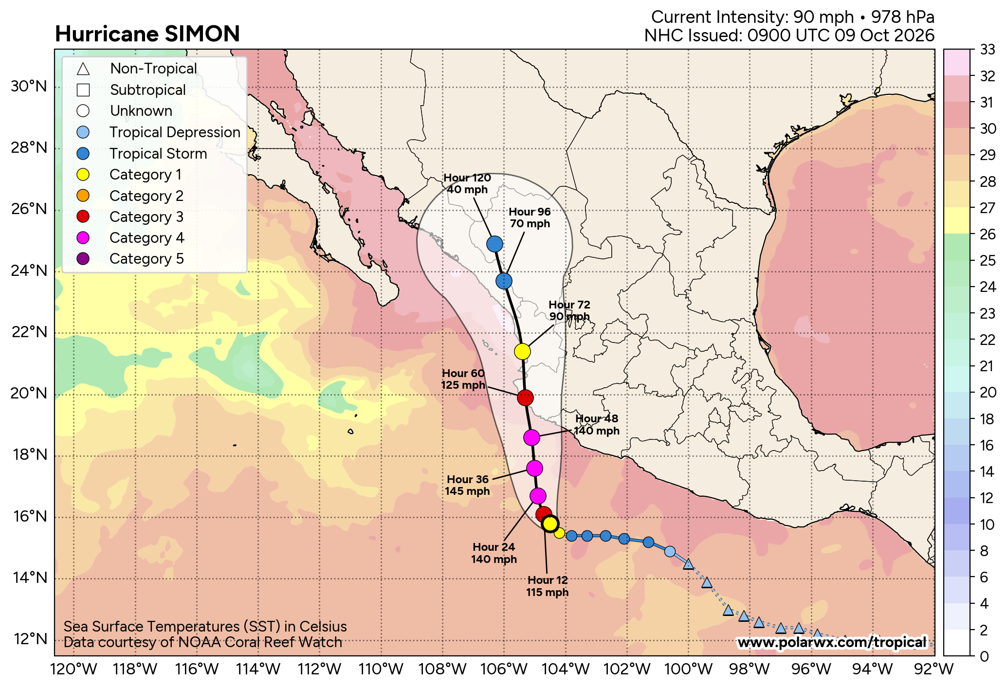
At a minimum central pressure of 978mb at this time, hurricane Simon is still well-above the levels required to trigger Mexico’s parametric IBRD Pacific named storm catastrophe bond.
But the forecast takes it directly ashore at landfall, so it will likely pass through the parametric trigger zones that run along Mexico’s coastline, just offshore.
The $175 million of IBRD CAR Mexico 2024 (Pacific) parametric catastrophe bond notes feature a parametric trigger design that requires a storm to have a minimum central pressure at or below specific levels in order to trigger a payout if it moves across the parametric grid lines.
Different areas of coastline have different payout factors attached to them as well, so location and intensity are the two key metrics for defining whether any payout will occur and those payouts can be from 25% of principal, right up to the full 100% or $175 million, depending on where any hurricane breaches the parametric box and how intense it is (how low the pressure falls).
For the cat bond to be triggered at all, the initial central pressure threshold is at 937mb or lower for the parametric zones, albeit that the exact location matters for what kind of payout that could result in.
Sources we’ve spoken with suggest, based on the forecast landfall region for hurricane Simon, a central pressure of 932mb or lower may be required to trigger a 25% payout for the cat bond, while a much lower pressure would be required for any payout to be at 50% to 100% of the cat bond principal. Sources also suggest that, based on the current NHC data, Simon may deepen to 940mb prior to landfall, although that obviously comes with uncertainty and pressures can be lower than expected, while how much rapid intensification is actually seen will clearly be a factor over the coming hours.
It remains uncertain at this time whether hurricane Simon will intensify sufficiently to see its minimum central pressure decline to the levels required to trigger Mexico’s parametric cat bond. It seems that in order for a triggering event to occur, hurricane Simon would need to intensify further than the latest NHC forecast data suggests, this will require watching for.
But, given the NHC forecast and the rapid intensification deemed underway, it clearly has the potential to pose a threat, meaning catastrophe bond market participants are likely now watching both Pacific (Simon) and Atlantic sides (Isaias).
 View all of our Artemis Live video interviews and subscribe to our podcast.
All of our Artemis Live insurance-linked securities (ILS), catastrophe bonds and reinsurance video content and video interviews can be accessed online.
Our Artemis Live podcast can be subscribed to using the typical podcast services providers, including Apple, Google, Spotify and more.