


Hurricane Idalia has intensified further in recent hours and has become a major Category 3 storm with 125 mph sustained winds. But further strengthening is now expected right up to landfall, where major hurricane Idalia is forecast to have Category 4 winds of around 130 mph when it reaches the Florida Big Bend area of the Gulf Coast.
 Given the ongoing intensification of hurricane Idalia, the forecasts for both wind speed and storm surge potential of the storm have increased again.
Now, the NHC’s latest forecast advisory is calling for hurricane Idalia to reach Category 4 before it strikes the Florida Gulf Coast, with peak sustained wind speeds of 132 mph forecast, while wind gusts are forecast to reach above 160 mph.
Update: Hurricane Idalia has already reached Category 4 strength, with 130 mph sustained winds as it bears down on the Florida Big Bend coastline.
It’s important to remember that hurricane Idalia remains a relatively compact storm, with hurricane wind speeds only extending outwards 25 miles and while that wind field will grow as it approaches landfall in the Big Bend near Apalachee Bay this morning local time, hurricane Idalia’s most ferocious winds will only be experienced by a relatively narrow stretch of land.
At the same time, the track has shifted westward slightly, potentially bringing hurricane force wind gusts closer to Tallahassee, which is seen as the largest insured exposure concentration within Idalia’s reach. The city is under a hurricane warning and meteorologists say that wind gusts of 65 mph to 75 mph are to be expected, while any further movement west in Idalia’s track would take stronger winds into the Tallahassee area.
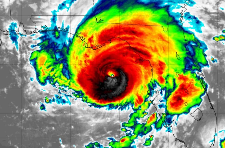
You can see the latest location for Idalia below, using Tomer Burg’s excellent map which shows wind speed forecasts in increments and sea surface temperatures as well, using the NHC data:

Major Hurricane Idalia is forecast to bring catastrophic storm surge and destructive winds into the Florida Big Bend region this morning local time, with landfall anticipated for around 8am or 9am.
The NHC’s latest advisory states, “Hurricane Hunter aircraft data indicate that maximum sustained winds have increased to near 125 mph (205 km/h) with higher gusts. Idalia is a category 3 hurricane on the Saffir-Simpson Hurricane Scale. Additional strengthening is forecast, and Idalia is forecast to become a category 4 hurricane before it reaches the Big Bend coast of Florida this morning.”
Importantly, the NHC also states that, “Idalia is likely to still be a hurricane while moving across southern Georgia, and possibly when it reaches the coast of Georgia or southern South Carolina late today,” which suggests that while the peak wind swathe will be relatively narrow, it will extend well inland.
Major hurricane Idalia is moving relatively fast as well, at near 15 mph and if that continues it also means the peak winds could be sustained longer inland. Conversely, should it slow or stall, then the coast could get battered for longer.
 Peak storm surge height forecasts have risen further with the ongoing intensification of hurricane Idalia, with now as much as 16 feet of surge expected for a wide area of the Florida Gulf Coast.
The 12 foot to 16 foot storm surge area in the map you can see from the NHC extends from Wakulla/Jefferson County line, FL to Yankeetown, FL.
Ochlockonee River, FL to Wakulla/Jefferson County line, FL is expected to see 8 to 12 feet of storm surge, while Yankeetown to Chassahowitzka, FL is expected to see 7 to 11 feet and Chassahowitzka, FL to Anclote River, FL 6 to 9 feet.
The Tampa Bay storm surge forecast has reduced slightly, to now 4 to 6 foot, as hurricane Idalia tracked further north and to the west than the original path had suggested.
Still, CoreLogic has reported that 808,321 single-family and multifamily homes along the Florida Gulf Coast with a reconstruction cost value (RCV) of approximately $238.4 billion are at potential risk of storm surge damage from Hurricane Idalia.
Now, that is how much property is exposed to surge along that stretch of coastline, so it shouldn’t be confused for potential loss quantum.
“Due to the sparsely populated forecasted impact area, there will likely be a lower insured loss ceiling from Idalia compared to last year’s Hurricane Ian,” explained Jon Schneyer, Director of Catastrophe Response, CoreLogic. “Even so, systems that make landfall along the Gulf Coast are likely to generate a more substantial storm surge than equivalent storms that hit the Atlantic Coast. As such, Hurricane Idalia is expected to bring hurricane-force winds, catastrophic storm surge of up to 15 feet and widespread inland flooding across Florida and the southeastern U.S.”
The insurance, reinsurance, catastrophe bond and insurance-linked securities (ILS) market continues to watch hurricane Idalia closely, but the outlook remains one where the primary market would be anticipated to retain a significant proportion of the losses, with reinsurance and ILS markets taking relatively less than they did with last years hurricane Ian.
The reasons for that are that hurricane Idalia is forecast to be a lower overall industry loss, with modelled projections all coming in below $20 billion at this time for the latest track forecast, even where Tallahassee takes a more significant hit from Idalia’s winds, while modelled runs that show hurricane Idalia threading a low-population needle of coastline suggest something in the mid-to-high single digit billions of dollars, we’re told.
So, that’s a current expectation for Idalia to deliver an insurance and reinsurance market loss of well below half, to significantly lower, than hurricane Ian’s losses from 2022.
Of course, the impacts to lives and livelihoods can still be significant and that could still be a major hit for some primary insurers, especially the more thinly capitalised. Given their use of reinsurance, even with higher attachments, some support from reinsurance and ILS markets to provide capital to help in paying claims would still be anticipated.
But still, the outlook does suggest that catastrophe bond losses will be minimal, or even mark-to-market only, while the broader private ILS and collateralized reinsurance segment impacts from hurricane Idalia are likely to be entirely manageable, with one ILS fund manager saying to us that, based on the modelled projections, their portfolio may easily absorb any Idalia losses within just one month of returns at this time of year.
There remains plenty of uncertainty though, as should hurricane Idalia head more northward and not turn east as much as anticipated, then Tallahassee could take more of a hit and raise the industry loss commensurately.
Yesterday, BMS Group’s Andrew Siffert said that the only historical hurricane that hit a similar area of Florida coastline was in 1896 and that in today’s dollars that could have equated to an $8 billion to $12 billion insurance market loss.
“However, there is still uncertainty with this number as many communities in this area have never experienced such strong winds before. These communities will be tested by all four hurricane hazards—surge, wind, rain, and tornadoes—with no modern reference point for such an event,” Siffert explained.
With the Tampa Bay loss scenario “off the table” Siffert notes that given the lower exposure and population in the region hurricane Idalia will come ashore, “The overall industry loss will be lower than if the storm had tracked up the Interstate 4 corridor. ”
“With the lower exposure concentration and the likelihood that overall attachment points have moved much higher on insurance companies’ catastrophe risk programs, this will likely be a retained event for some insurance companies with limited reinsurance impacts,” he continued.
Siffert added, “With little historical analogs, a lot of weight will be put on the catastrophe model to understand losses. In looking at some of the similar events within their catalogs, the loss should end up in the range of $3 to $6B, but this all depends on how far the wind field impacts the Tallahassee area. Right now, it looks like the strongest winds will mostly move over rural areas and large parts of central Florida that swamp, such as the Mallory Swamp and the Osceola Wildlife Managment, up into Georgia Okefenokee Swamp area, all with a fairly low population density providing lower industry losses.”
With landfall now just hours away, Florida is all but guaranteed a major hurricane impact again in 2023 and while the population density may be lower, the threat to lives is not and it is to be hoped that evacuation processes have worked and those in the path of the worst winds and surge are protected or out of harms way by now.
Track storm or hurricane Idalia and the entire 2023 Atlantic tropical storm and hurricane season on our dedicated page and we’ll update you as new information emerges.
![]() View all of our Artemis Live video interviews and subscribe to our podcast.
View all of our Artemis Live video interviews and subscribe to our podcast.
All of our Artemis Live insurance-linked securities (ILS), catastrophe bonds and reinsurance video content and video interviews can be accessed online.
Our Artemis Live podcast can be subscribed to using the typical podcast services providers, including Apple, Google, Spotify and more.


