


Hurricane Nicole is approaching the Florida coastline with Category 1 winds and the massive storm has continued to expand, promising impacts for a significant portion of the state, as well as the region to the north.
Hurricane Nicole has expanded significantly to carry a wind field that sees tropical storm force winds that now stretch some 780 km out from its center, while hurricane force winds extend out 35 km, especially to the north where the wind field extends furthest.
Hurricane Nicole has maximum sustained winds of 75 mph with gusts estimated at up to 92 mph by the NHC, so remains a Category 1 storm.
The minimum central pressure is estimated at 980mb, with Nicole deepening, as the hurricane models had predicted and now set to reach Florida’s coast at hurricane strength.
Given the significant wind field of tropical storm Nicole, a storm of this size can still cause significant impacts over a particularly wide area, even at a low category, hence insurance, reinsurance and ILS market interests will be watching how things develop as Nicole makes landfall in Florida today.
The latest NHC updates states that “Nicole is moving toward the west-northwest near 14 mph (22 km/h). A turn toward the northwest is expected later today, followed by a turn toward the north and north-northeast on Friday. On the forecast track, the center of Nicole will move onshore the east coast of Florida within the hurricane warning area within the next couple of hours. Nicole’s center is then expected to move across central and northern Florida into southern Georgia today and tonight, and into the Carolinas on Friday.”
Landfall is imminent, with Nicole just 25 miles off the coast of Florida now, and landfall expected in the next hour or two.
With wide-reaching effects, hurricane Nicole is likely to be felt across a significant area of the Florida peninsula.
While wind damage won’t be a particular issue at Category 1 strength, damage can still be caused and properties left damaged after hurricane Ian could be especially exposed.
In addition, the storm surge, rainfall and wide-reach of hurricane Nicole could be sufficient to drive losses that may affect the insurance and perhaps even reinsurance industry.
Andrew Siffert, Senior Meteorologist at broker BMS Group, said in an update that, “This will be a manageable cat event, and an event that might hurt more for carriers as event loss might end up falling below carriers’ catastrophe reinsurance programs, mainly since these retentions have been pushed up over the last several years.
“The impacts will be broad, like Hurricane Matthew, which recently tracked up the entire east coast of Florida with tropical-storm-force winds and coastal erosion. However, Matthew still caused about $1B dollars of insurance industry loss without making landfall.
“Hence, a one or two-billion-dollar loss is not out of the question here if Nicole makes landfall as a Category 1 hurricane and the windfield stays as large.”
While losses from hurricane Nicole would likely be largely retained by primary carriers, there is a chance some stressed reinsurance programs respond for carriers that have already taken losses after Ian.
The latest forecast track and expected wind speeds can be seen on Tomer Burg’s excellent map below, which uses NHC data:
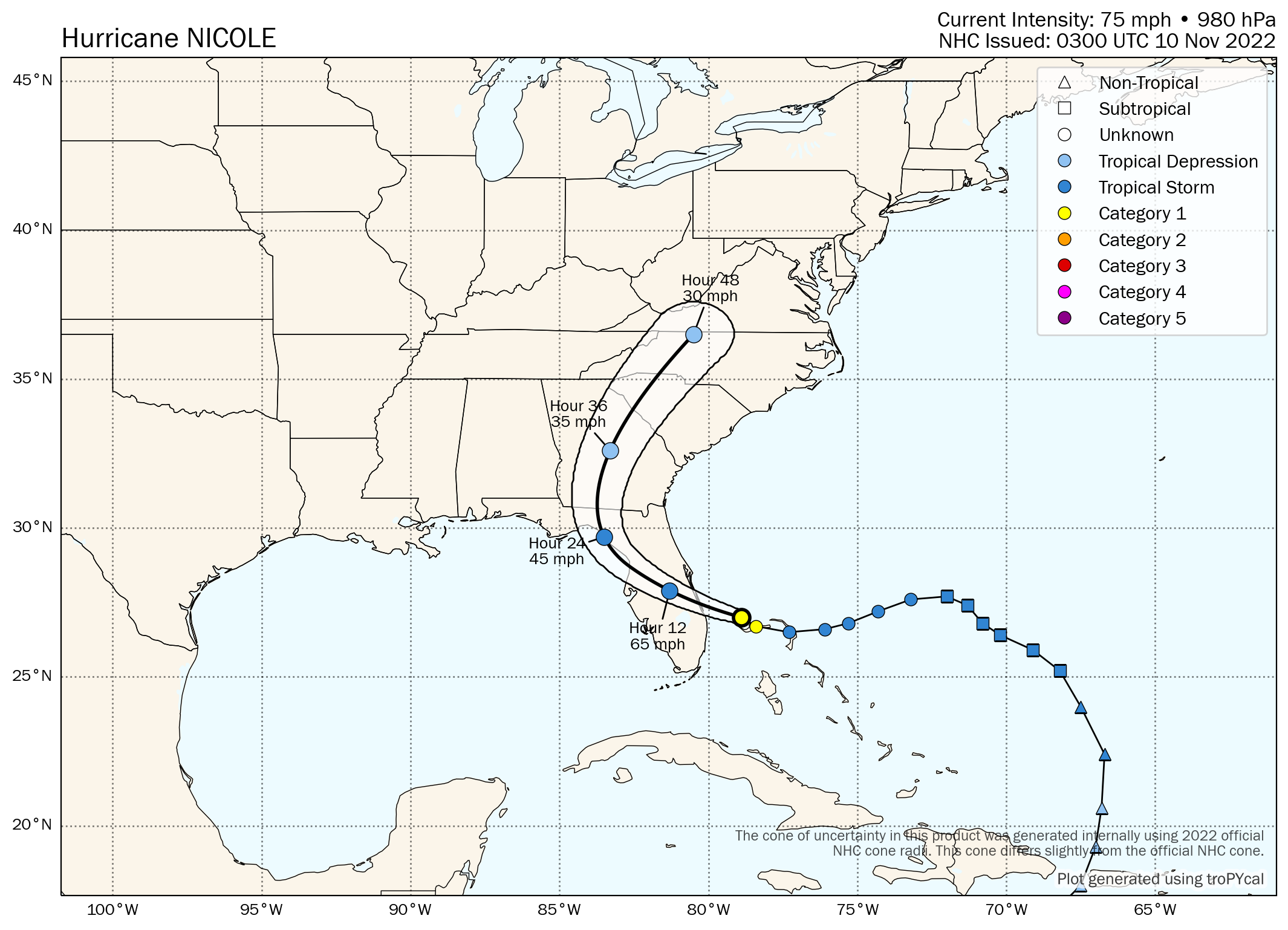
The NHC’s forecast cone can also be seen below:

As you can see, the forecast continues to call for hurricane Nicole to be named as this storm intensifies on approach to Florida’s east coast.
The NHC says that “Maximum sustained winds are near 75 mph (120 km/h) with higher gusts. Little change in strength is expected until Nicole makes landfall along the Florida east coast. Nicole is expected to weaken while moving across Florida and the southeastern United States today through Friday, and it is likely to become a post-tropical
cyclone by Friday afternoon.”
Storm surge peaks are still forecast to reach 3 ft to 5 ft along the Florida east coast from North Palm Beach to Altamaha Sound including the St. Johns River to the Fuller Warren Bridge, while the Bahamas could see surge peak at 6 foot.
Rainfall totals from the storm are forecast to reach as much as 8 inches, ample for significant flooding, with wide spread totals of 2 to 6 inches in Florida and states to the north.
The prospect of a hurricane strength storm, with a tropical storm wind field extending more than 780 km out from its center, could threaten an impactful coastal and inland flood event, while also meaning strong and potentially damaging winds reach a relatively significant area of Florida.
Meteorologists continue to talk about the slow-moving nature of storm Nicole as well, which could pile water up against the Florida coast across more than one tide cycle, exacerbating the coastal flood effects.
Nicole remains a reminder that the tropics can throw storm events in the direction of Florida’s peninsula even in November, something the insurance and reinsurance industry has become far less used to in recent years.
You can track the 2022 Atlantic hurricane season on our dedicated page.
![]() View all of our Artemis Live video interviews and subscribe to our podcast.
View all of our Artemis Live video interviews and subscribe to our podcast.
All of our Artemis Live insurance-linked securities (ILS), catastrophe bonds and reinsurance video content and video interviews can be accessed online.
Our Artemis Live podcast can be subscribed to using the typical podcast services providers, including Apple, Google, Spotify and more.


