


Meteorologists eyes have all turned towards the Atlantic tropics in recent days, as forecast models have increasingly pointed towards an improving chance of depressions and storms forming, but the Atlantic high and dry Saharan air continues to make the formation of any storms or hurricanes very uncertain.
As ever, some of the forecast models are more bullish on this formation than others, particularly the GFS.
But, the National Hurricane Center (NHC) now has three areas labelled for potential tropical development over the next week, meaning the Atlantic does appear to be slowly wakening from its recent period of inactivity.
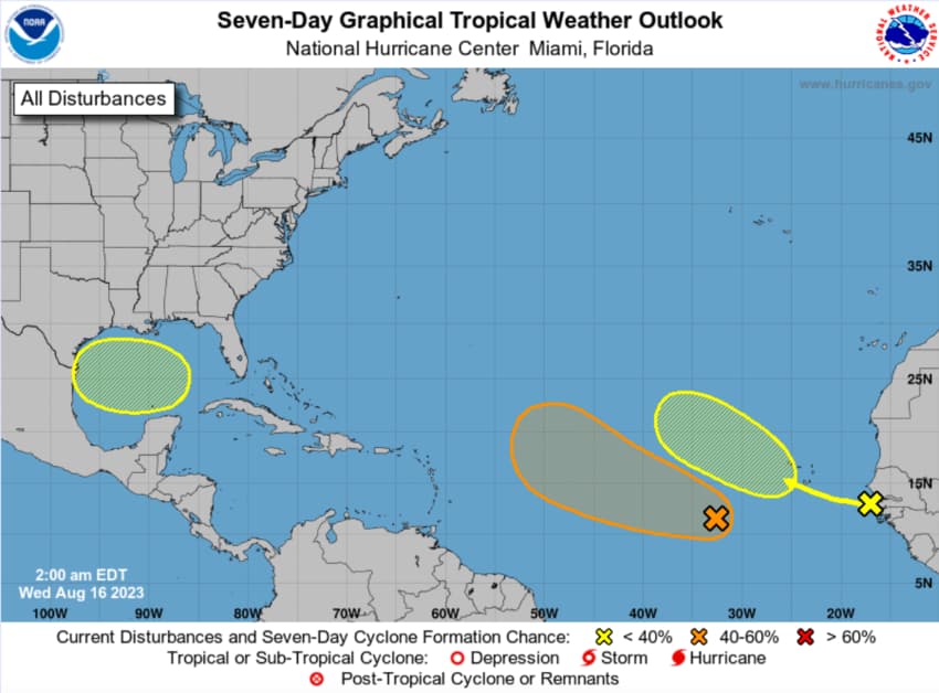
The graphic above from NOAA shows an area in the Gulf of Mexico that is given a 20% chance of development within 7 days, an area in orange in the west Atlantic that is given a 20% chance of development in 48 hours, or 40% within 7 days, and an area further west towards Africa that is given just a 10% chance of development in 48 hours, or 30% within 7 days.
However, while appearing primed for development of depressions and storms, meteorologists cite the existence of a strong Atlantic high and the potential for additional dry air to come from the Sahara, as factors leading to uncertainty over just what may form and where.
Forecast models though, as they tend to, are more bullish for storm formation, in particular the GFS which is known for offering up severe storms in its longer-range forecasts.
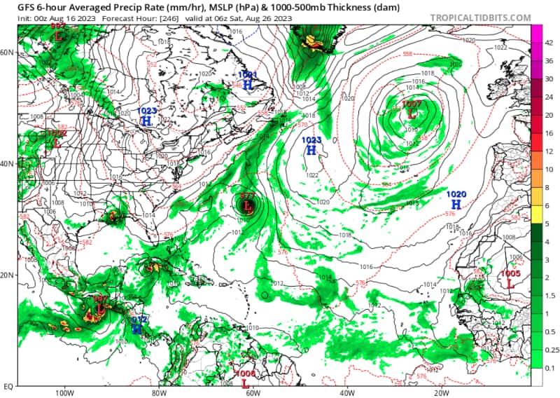
For Saturday August 26th, the GFS model offers up a strong tropical storm or hurricane not far from Bermuda (seen below, image from TropicalTidbits.com), which comes from one of the areas of potential development in the west Atlantic in NOAA’s graphic further up.
The ECMWF forecast model does not share the same opinion, but it does show a tropical storm moving in the general direction of Bermuda, although a few days slower to develop and move (shown below).
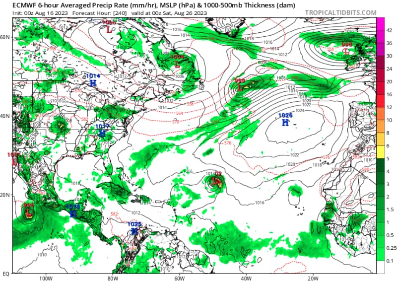
Interestingly, it seems the genesis for this storm under the GFS model is the more easterly of the two disturbances in the far Atlantic, while the ECMWF sees it as more of a merging of their areas of disturbance and slower formation into something that could become a tropical storm or hurricane.
It’s also interesting to note that other forecast models, the CMC, Navgem and more, all see a chance for the development of a tropical storm in the same general region of the Atlantic, between August 22nd and 26th.
The current disturbance in the Gulf of Mexico is seen as having a slim chance of development and if it does, the only model that shows it is the GFS and that tracks it towards the Mexico – Texas border as a relatively weak tropical storm.
More concerning and likely to keep eyes on the tropics, is what the GFS model currently shows for forecast runs further out at hours 250 through 360.
The GFS model shows a tropical storm forming south of Jamaica, then moving north and intensifying as it nears the Florida Peninsula western coastline, before spinning north and west again ad intensifying further on a track towards New Orleans as a major hurricane with pressure down below 940mb (see below).
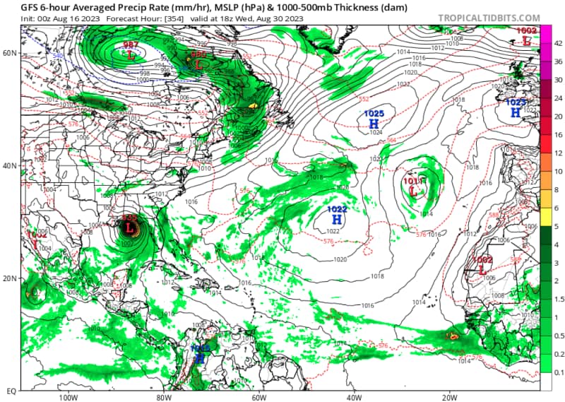
The above is the type of forecast chart that insurance and reinsurance interests would dread seeing, were it not so far out into the future.
It’s important to note that the GFS model is well-known for producing severe storms in its longer-range forecasts and we cannot see even the genesis of this particular storm in any other model as of this time, although we do not have access to runs quite as far out as for the GFS.
But, it is a further sign of the forecast models becoming more bullish on activity picking up in the Atlantic tropics over the next few weeks.
As we’ve been reporting, forecasters have all increased the numbers of storms and hurricanes they expect to see, with most citing an expectation that conditions will become more conducive as the season progresses and that the record warm SSTs, alongside a below-normal wind shear forecast, slightly below-normal Atlantic trade winds and a near- or above-normal West African Monsoon, are being seen as factors that can help counteract the effect of El Nino on storm formation.
With the sea surface temperatures (SSTs) extremely warm in the Gulf of Mexico and parts of the Atlantic, including near the eastern seaboard and Florida, there is always a chance of storm formation at this time of year, if the effects of wind shear, dry air, Saharan dust and the significant high in the Atlantic, either reduce in their effects or can all be overcome.
Track the 2023 Atlantic tropical storm and hurricane season on our dedicated page and we’ll update you as new information emerges.
![]() View all of our Artemis Live video interviews and subscribe to our podcast.
View all of our Artemis Live video interviews and subscribe to our podcast.
All of our Artemis Live insurance-linked securities (ILS), catastrophe bonds and reinsurance video content and video interviews can be accessed online.
Our Artemis Live podcast can be subscribed to using the typical podcast services providers, including Apple, Google, Spotify and more.


