Accumulated cyclone energy (ACE) is just one of the measures used to identify how active or severe a tropical cyclone or hurricane season has been. It’s a measure used by the National Oceanic and Atmospheric Administration (NOAA) to express the activity of individual tropical storms and entire seasons, using an approximation of the energy used by a tropical storm over its lifetime. The NOAA uses the ACE of a whole season, which is the sum of the ACE for every storm, to help understand how active it was.
Accumulated cyclone energy ACE is often discussed in the forecasts that we publish prior to the Atlantic hurricane season, it’s just one of the figures used in forecasts, alongside the number of tropical storms and hurricanes that are expected to form. What’s interesting about the ACE numbers is that they are easily translated into a cumulative index showing the severity of a season.
The NOAA themselves uses an ACE Index, which they explain as “a wind energy index, defined as the sum of the squares of the maximum sustained surface wind speed (knots) measured every six hours for all named storms while they are at least tropical storm strength” to help them analyse the hurricane season.
It’s an interesting way to view the potential severity of the hurricane season for re/insurers as well and looking at past season ACE indices can give an insight into the periods of the year when activity, or energy, is highest in the tropical Atlantic.
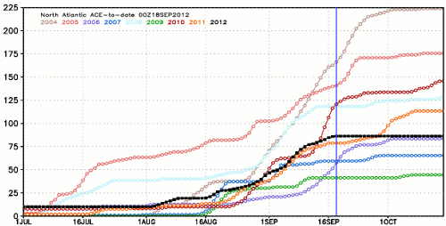
Yesterday we saw an interesting comment on Twitter from Dr. Ryan Maue, a research atmospheric scientist who works for WeatherBELL Analytics Inc. a meteorological consulting firm focused on weather risk. Ryan has a great website where he looks at tropical cyclones with a particular focus on their ACE scores. He tweeted an image yesterday which shows that the cumulative ACE for the hurricane season has tended to flat-line from mid-September to mid-October in recent years. He shared the graphic below (click on the image to see a larger version).
What’s interesting about this image is exactly what Ryan highlights, the fact that the cumulative ACE total for each year tails off around the middle of September in the last few years. This suggests that (in recent years) hurricane risk has been at its highest prior to mid-September, and looking at the graph it seems that August to mid-September is the period of time when reinsurers (and catastrophe bond investors) should perhaps be most concerned. 2012, shown in the graph as the black line, appears to be tailing off in similar fashion.
Of course this doesn’t mean that hurricane season is over, or that there is no risk of major landfalling storms after mid-September. In fact there is every risk, but the pattern in recent years seems to be for the season to tail off pretty rapidly from late September.
If the 2012 season follows this pattern and is benign up to the end of November it will please reinsurers and cat bond investors greatly. Reinsurers stand to come out the other side of the hurricane season left with stronger reserves due to having little in the way of catastrophe claims to pay, while cat bond investors can expect returns to be positive for the remainder of the season if it stays quiet.
Accumulated cyclone energy (ACE) provides a different view on the hurricane season and one which perhaps provides a better insight into just which months of the year are most exposed to hurricane formation. Of course it doesn’t include any landfall factors so can’t be used as a predictor of losses, but it is another measure that the re/insurance and cat bond sector can look at this year and hope that the rest of the season leaves them unscathed.
Of course, this wouldn’t be Artemis if we didn’t add a brief thought as to how you could potentially use this data. If you could correlate or combine the ACE index with tropical storm landfall factors to create a ‘tropical cyclone energy and landfall risk index’ could you use that to trigger instruments such as a cat bond, ILW or contingent reinsurance policy? The combined metrics of the cumulative energy of the tropical cyclone season and actual storm landfall might just make an interesting parametric trigger. Discuss…
Remember you can track Atlantic tropical storms and hurricanes as they form here.
 View all of our Artemis Live video interviews and subscribe to our podcast.
All of our Artemis Live insurance-linked securities (ILS), catastrophe bonds and reinsurance video content and video interviews can be accessed online.
Our Artemis Live podcast can be subscribed to using the typical podcast services providers, including Apple, Google, Spotify and more.


