




As major hurricane Simon’s path shifted west it appears to have remained offshore of the important parametric trigger zones related to the $175 million IBRD CAR Mexico 2024 (Pacific) catastrophe bond, according to analysis by Isacco Loconte an insurance-linked securities (ILS) Investment Specialist at asset manager Azimut Switzerland SA.
As we had been reporting over the weekend, hurricane Simon’s minimum central pressure, a critical factor in determining whether any payout would come due for the catastrophe bond, did deepen to a sufficiently low level to activate a payout should the storm’s track have crossed into any of the parametric trigger boxes.
At one stage that was seeming increasingly likely to occur. But, again as we reported, it appeared that hurricane Simon had diverted away from the parametric zones just prior to breaching any of them and that no payout would come due in this case.
Analysis by Loconte suggests the same, as he has interpolated the hurricane’s path using the NHC data and found that while it was a very close call, hurricane Simon does not seem to have come close enough to activating the parametric trigger in this case.
“Based on preliminary NHC track data, the bond looks safe from a trigger event,” Loconte explained.
“Initial measurements indicate that Simon’s minimum central pressure (MSLP) entered the critical threshold for the bond (below 937 mb) at four track points between Oct 10 (18:00) and Oct 11 (12:00). While those pressure levels were strong enough to meet the L1 payout threshold for the parametric zones, the hurricane trajectory worked in the bond’s favor.”
Based on the parametric trigger design, hurricane Simon’s central pressure would have needed to be at 932mb or lower to activate a payout from the zones it came closest to. As we reported, at one stage the pressure deepened to 928mb as it approached the zone, but then the factor that drove the near-miss was the fact the storm’s track shifted slightly west and it moved parallel to the coast while a weakening trend began.
Loconte said, “As shown in the map below, the hurricane veered slightly west and remained offshore, avoiding direct landfall over the Jalisco region. Consequently, all four high-intensity points occurred at a safe distance outside the defined trigger zones.”
You can see Loconte’s analysis in the graphic below, showing the track veering to the west and away from the trigger zones.
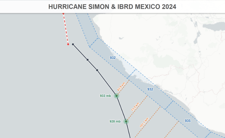
You can see how close it came in the image above and had the storm continued on its original forecast path there was a strong chance Simon could have been very close to activating a 25% payout of the catastrophe bond’s principal.
Hurricane Simon is now set to make landfall further up the west coast of Mexico, but as the weakening trend has continued over night, there is now no risk of a trigger activation event occurring. The storm remains a danger to those on the coastline in the future landfall region, but having weakened the impacts should now be lower than if it had followed the original forecast path to hit Jalisco state head on.
Loconte explained, “Despite remaining forecast uncertainty over the coming hours (whether Simon turns further offshore or makes landfall further north in Mexico), the storm is expected to gradually lose intensity. As the storm weakens, its MSLP will move safely away from any bond trigger parameters.”
 View all of our Artemis Live video interviews and subscribe to our podcast.
All of our Artemis Live insurance-linked securities (ILS), catastrophe bonds and reinsurance video content and video interviews can be accessed online.
Our Artemis Live podcast can be subscribed to using the typical podcast services providers, including Apple, Google, Spotify and more.