


Hurricane Beryl caused significant impacts to some of the Caribbean Windward Islands yesterday and after passing that island chain resumed its intensification, recently being upgraded to a Category 5 storm with 165 mph sustained winds, the strongest hurricane this early in the year on-record for the Atlantic basin. Latest updates.
Meteorologists say it is an ominous sign for what is forecast to be a very active 2024 Atlantic hurricane season, with hurricane Beryl an example of the ample warm water fuel available for storms to form and intensify.
Beryl has broken numerous records now, with those same meteorologists pointing to the fact the waters in the Caribbean are at temperatures more normally seen in September already and that the kind of activity seen with hurricane Beryl is more typical of peak hurricane season.
Beryl was already known to be the the earliest category 4 Atlantic hurricane on record and also the first major hurricane east of the Lesser Antilles on record for June.
It was being cited as an extremely rare occurrence for this time of the year and now having intensified further to Category 5 becomes even more so.
Major hurricane Beryl is still strengthening as well, having been upgraded to Category 5 with sustained winds of 160 mph at 03:00 UTC today, but then a further update at 06:00 am UTC now puts the storm at 165 mph sustained winds.
Beryl’s minimum central pressure has deepened significantly now to 935mb, while hurricane-force winds extend outwards up to 40 miles from the center and tropical storm force winds up to 125 miles.
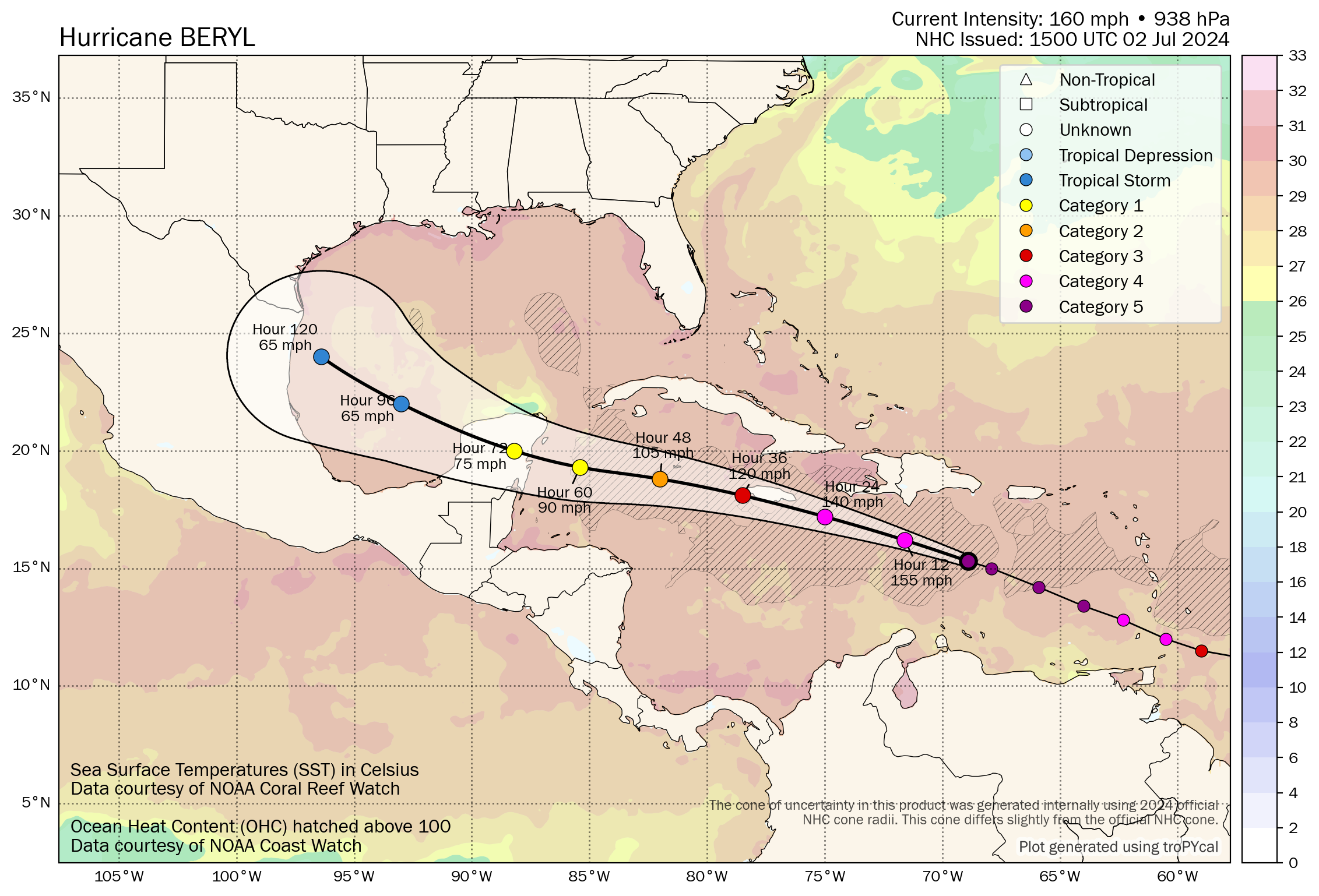
The map below is from Tomer Burg’s excellent resources (click it for the very latest version).
The NHC said, “Beryl is a category 5 hurricane on the Saffir-Simpson Hurricane Wind Scale. Fluctuations in strength are likely during the next day or so, but Beryl is expected to still be near major hurricane intensity as its moves into the central Caribbean and passes near Jamaica on Wednesday. Additional weakening is expected thereafter, though Beryl is forecast to remain a hurricane in the northwestern Caribbean.”
For Jamaica, hurricane Beryl is currently forecast to near the island with slowly weakening sustained winds of 120 mph to 110 mph.
Beryl is forecast to pass slightly to the south, so Jamaica’s World Bank issued catastrophe bond, the $150 million IBRD CAR Jamaica 2024 transaction, will be watched closely, as should Beryl move any nearer that cat bond could be considered at some risk of triggering and even a partial payout.
Hurricane Beryl needs to make a relatively close approach to threaten Jamaica’s catastrophe bond, but the latest track update at 09:00 UTC has shifted it slightly further north and nearer to the island, raising the uncertainty for these notes.
So, Jamaica’s cat bond will remain on-watch for the insurance-linked securities (ILS) market over the next day or so.
Beyond Jamaica, hurricane Beryl is still forecast to continue weakening and to reach the Yucatan peninsula of Mexico as a strong Category 1 storm.
At that level of intensity, hurricane Beryl would not be expected to pose a significant threat to Mexico’s Atlantic coast hurricane catastrophe bond, another World Bank issuance (a $125m Atlantic hurricane tranche of the IBRD CAR Mexico 2024 deal). It would require Beryl to maintain greater intensity, for that cat bond to be triggered, we believe.
It’s worth noting here, that Beazley’s December 2023 $100 million London Bridge 2 PCC Limited (Fuchsia 2023-1) catastrophe bond also carriers Caribbean hurricane exposure, including for the just affected St Vincent and the Grenadines, as well as Jamaica.
The Fuchsia 2023 catastrophe bond would attach at $500 million of losses to Beazley and it’s worth noting that Caribbean named storm exposure only contributes a tiny 0.61% of the expected loss of the cat bond notes, suggesting it would need to be a historical hurricane impacting multiple Caribbean islands for Beazley to take sufficient ultimate net losses to breach the trigger. This cat bond does also provide US named storm coverage, so seems more designed to pick up losses from a storms passage through the Caribbean, but with any US landfall impacts more likely to be responsible for a triggering of it. It is another cat bond to watch though.
Beyond Mexico, Beryl is currently forecast to cross the Yucatan and emerge weakened as a strong tropical storm in the Gulf of Mexico, after which a left turn into northern Mexico is anticipated at this time.
The most at-risk of the catastrophe bonds in the path of hurricane Beryl continues to be the Jamaica issuance, which we understand requires a minimum central pressure of lower than 969mb with a storm that makes a direct hit on the island, or 950mb or lower for a storm that makes a close pass to it.
The current track is still for a pass to the south of Jamaica at this time, but it has moved a little north at the last update. It could all come down to intensity and whether hurricane Beryl can maintain the low central pressure levels after the expected weakening begins, as its path looks set to come very near to the parametric box arrangement for the cat bond trigger.
More broadly, the insurance market will anticipate losses from the Windward Islands, likely regionally retained and by specialists operating there, in the main.
A hit on Jamaica could be a larger insurance market loss, with the potential for some reinsurance coverage to respond, after which a Yucatan landfall and its financial impacts will depend on the location affected.
Beyond Mexico, if the forecast doesn’t change, then the United States may avoid any significant impacts from this historic storm, aside from some torrential rains that could move northwards in Beryl’s wake. Any change in the forecast though, or a more direct route towards the Gulf Coast and that could change dramatically, as the waters there are plenty warm enough to sustain a strong hurricane, although some wind shear may inhibit the chances of a particularly strong storm in the Gulf at this time, some forecasters say.
Updates:
As Tuesday morning progressed, as of 12:00 UTC, major hurricane Beryl maintained its intensity, with still sustained winds of 165 mph and gusts estimated to be around 200 mph.
The minimum central pressure of hurricane Beryl was reported to be 934mb at 12:00 UTC, after hurricane hunter aircraft found little change in strength.
The NHC said, “Beryl is moving toward the west-northwest near 22 mph (35 km/h) and is forecast to continue moving rapidly west-northwestward during the next couple of days and turn westward by Thursday. On the forecast track, the
center of Beryl will move quickly across the southeastern and central Caribbean Sea today and is forecast to pass near Jamaica on Wednesday and the Cayman Islands on Thursday.
“Beryl is still expected to be near major hurricane intensity as it moves into the central Caribbean and passes near
Jamaica on Wednesday and the Cayman Islands on Thursday. Additional weakening is expected thereafter, though Beryl is forecast to remain a hurricane in the northwestern Caribbean.”
The latest forecast says that hurricane conditions are expected for the Jamaican coast on Wednesday, with hurricane conditions also likely for the Cayman Islands on Thursday.
Storm surge of up to 6 foot is expected for Jamaica and up to 3 foot for the Caymans, while rainfall totals are expected to be up to 12 inches locally.
At this time the outlook for Jamaica’s catastrophe bond remains uncertain, with the exact path of hurricane Beryl and its intensity key to determining whether the notes could be triggered or not.
One model, the HWRF, shows hurricane Beryl close to Jamaica’s south coast with a central pressure of 955mb, at which level there may be some chance of exposure, with the first amount of 30% of principal potentially at risk, if that scenario played out. We have to stress though, there remains significant uncertainty at this time.
As of the 15:00 UTC update from the NHC, major hurricane Beryl is said to have 160 mph sustained winds still, so slightly weaker but no significant change in terms of its potential to be damaging. Minimum central pressure is slightly higher at 938mb.
The NHC update said, “Weakening is forecast later today, but Beryl is still expected to be near major hurricane
intensity as it moves into the central Caribbean and passes near Jamaica on Wednesday and the Cayman Islands on Thursday. Additional weakening is expected thereafter, though Beryl is forecast to remain a hurricane in the northwestern Caribbean.”
Hurricane Beryl’s core remains relatively tight, with hurricane-force winds still said to extend outwards up to 40 miles from the center. But the storm is growing, with now tropical storm force winds extending outwards up to 175 miles.
Notably though, the latest update from the NHC has updated the forecast path for major hurricane Beryl, taking the storm much closer to Jamaica, potentially a direct hit.
The latest forecast data suggests hurricane Beryl could still be a strong 120 mph storm at the time it nears Jamaica, putting the catastrophe bond more firmly on-watch as the track has also moved closer to the island.
If you look at the tracking map further up this page, which is the latest at this time, the forecast path for hurricane Beryl has moved closer to Jamaica, suggesting the storm could brush the coast with winds around 120 mph, which could be sufficient to be a triggering event, given how wind speeds tend to extrapolate to central pressure.
Read our latest update: Hurricane Beryl forecast path keeps Jamaica catastrophe bond on watch.
Track the 2024 Atlantic tropical storm and hurricane season on our dedicated page and we’ll update you as new information emerges.
![]() View all of our Artemis Live video interviews and subscribe to our podcast.
View all of our Artemis Live video interviews and subscribe to our podcast.
All of our Artemis Live insurance-linked securities (ILS), catastrophe bonds and reinsurance video content and video interviews can be accessed online.
Our Artemis Live podcast can be subscribed to using the typical podcast services providers, including Apple, Google, Spotify and more.


