


A second and larger M7+ earthquake struck the Kumamoto region of Kyushu, the southernmost main island of Japan, during the early hours of Saturday morning local time. Damage in the region is now much more extensive, with many reports of buildings and structures downed.
 This larger earthquake occurred at 01:25 Saturday, local time, 15:25pm GMT, recorded as a magnitude 7.3, striking the same region as Thursday’s two magnitude 6+ quakes (which are now considered foreshocks) and again at a shallow depth of 10km, causing strong shaking and considerable damage.
Damage is now considered much more widespread, with this larger M7+ earthquake occurring on a much longer fault-line, resulting in damage to more towns, cities and infrastructure in the region, raising the possibility of impact to the reinsurance and ILS market.
Gavin Hayes, USGS research geophysicist, explained to the BBC; “The ground surface would have moved in the region of 4-5m (yards). So, you are talking very intense shaking over quite a large area. And that’s why we’ll probably see a significant impact from this event.”
This shakemap from the USGS, below, shows how much wider the area affected by severe shaking has been with this second earthquake, than seen with Thursday’s quake shakemap. Friday’s quake is considered 15.8 times stronger that the ones the day before, according to AIR Worldwide.

Kumamoto, Japan earthquake shake map - From the USGS
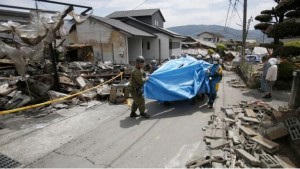
Damage to roads and infrastructure appears considerable in the region, from reports, while the number of buildings, both residential and commercial, downed or with structural damage has increased significantly from those damaged by Thursday’s quakes. A dam has been damaged and towns evacuated as a result.
19 deaths have been reported and hundreds of injuries, while there may be as many as one hundred people still trapped in downed buildings. Rescue workers have been called into the region from all over Japan.
Mt. Aso, an active volcano, was near the earthquake epicenter and a small eruption was recorded at the time of the quake. The volcano is now being monitored closely. Scientists say further large aftershocks are likely in the region.
After the first quakes on Thursday ILS fund investment managers and reinsurance companies were not expecting any significant impact to positions, either catastrophe bond, private ILS and collateralised reinsurance, or indeed traditional reinsurance.
Swiss investment managers Twelve Capital said, of those events, that they did not expect any impact to catastrophe bonds or private ILS positions, while fellow Swiss ILS manager Plenum Investments said the losses from Thursday’s events would be well below attachment points for any Japan quake exposed cat bonds.
But after Friday’s much more damaging quake it looks much more likely that some reinsurance support for paying losses will be sought by Japanese insurers and perhaps by Zenkyoren, the Japanese National Mutual Insurance Federation of Agricultural Cooperatives.
The reinsurance and ILS market holds significant exposure to Japanese earthquake risk, with many ILS funds having collateralised reinsurance or private ILS positions which could be exposed. There will be a period of uncertainty as the extent of the damage becomes clearer, after which we could see some managers establishing small side-pockets due to this latest quake.
Catastrophe bonds, meanwhile, are less likely to be affected, due to their considerably higher attachment points. Most Japan quake cat bonds are relatively remote risk, requiring events that cause a single insurer losses in the hundreds of millions of US dollars.
The catastrophe bond market has over $1.8 billion of outstanding pure Japan quake exposed bonds, all listed in our Deal Directory.
There is, of course, the question of number of events and aggregate reinsurance covers or cat bonds. It seems likely that with these quakes all occurring within a roughly 24 hour period that it will be difficult, if not impossible, to separate losses and they are likely to be treated as one event for reinsurance purposes.
It will be a few days before any insurance industry loss estimates become available, but the USGS estimated that the stronger M7+ earthquake could result in an economic loss of over USD$10 billion, which could represent an insured loss into the low billions of US dollars.
While the chance of an impact to ILS funds, likely through collateralised reinsurance positions, as well as to reinsurance sidecars, has certainly increased with this stronger earthquake, it remains likely that losses would not be particularly significant for any one manager as they typically cover more severe events.
Impact Forecasting, the risk modelling and analytics arm of reinsurance broker Aon Benfield gave the following event update:
Overview
A major earthquake struck southern Japan for the second time in nearly 24 hours early on April 16, causing catastrophic devastation and human casualties. The United States Geological Survey (USGS) registered the tremor at magnitude-7.0 with an epicenter located just 1.0 kilometer (0.6 miles) west-southwest of Kumamoto City, Japan in Kumamoto Prefecture. The Japan Meteorology Agency (JMA) upwardly revised its registered magnitude to 7.3. The temblor occurred at 1:25 AM local time April 16 (16:25 UTC April 15) and at a shallow depth of 17.5 kilometers (10.9 miles), which helped to amplify the intensity of shaking across Kumamoto and neighboring prefectures. The USGS confirmed that the damaging M6.2 and M6.0 events on April 14 were foreshocks.The JMA quickly initiated a Tsunami Advisory for coastal regions on Kyushu Island along the Ariake and Yatsushiro seas, but it was later lifted. Hundreds of aftershocks were recorded by the USGS and JMA in the immediate hours following the main jolt. At least seven aftershocks rated magnitude-4.0 or stronger (including M5.8 and M5.7) rattled the region. The earthquake was widely felt across Japan, with some buildings swaying more than 900 kilometers (550 miles) away from the epicenter.
Japan’s Fire and Disaster Management Authority (FDMA) had previously noted that the April 14 event had left at least 10 people dead and more than 1,200 others injured. That M6.2 tremor was located roughly 13 kilometers (8 miles) south-southeast of the April 16 M7.0 event.
Event Details
As of 23:00 UTC April 15, daybreak was confirming that extensive and catastrophic damage has occurred throughout Kumamoto City (population ~735,000). There were three confirmed fatalities, and hospitals in Kumamoto had counted more than 470 injuries. These totals were expected to substantially rise as full relief and recovery efforts began across the prefecture.Early reports from local media and FDMA indicated that a high volume of homes and businesses had either completely collapsed or sustained significant damage. The violent earthquake and subsequent aftershocks left the entire city of Kumamoto without access to water and more than 200,000 Kyushu households without electricity as gas and water pipes were ruptured. Media outlet NHK showed several large fires raging out of control that were destroying an unknown number of homes and buildings. Local officials indicated that hundreds of residents – if not more – were trapped under fallen building collapses. Authorities were determining whether to evacuate the Kumamoto Shimin Hospital given fears of collapse. The hospital, like many other structures in the region, was weakened following the April 14 foreshock.
The FDMA confirmed that 66 people were trapped inside a nursing home in Mashiki, which incurred the most damage from the April 14 foreshock. Several other similar reports of trapped residents in Kumamoto, Mashiki, and Uto were emerging as well. The lone initial fatality was blamed on a large fire that burned an apartment complex in Kumamoto City. The Japanese Defense Minister stated that more than 20,000 soldiers were scheduled to be deployed to help in search and rescue. One large landslide near Kumamoto was reported and a bridge collapsed. The weather forecast for late in the day on April 16 showed the likelihood of heavy rain and gusty winds as a storm system approached from the southwest. This was expected to increase the risk of landslides or further weaken structures already on the verge of collapse from the hundreds of earthquakes in the previous 36 hours. In Uto City, police reported that the City Hall building was heavily damaged with walls showing severe cracking or partial collapse. The historic Kumamoto Castle had stones tumbling down the walls of the building and a separate wooden structure in the larger complex was destroyed. It had incurred previous damage from the April 14 foreshock. At the time of the April 16 event, more than 44,000 Kumamoto residents were still living in evacuation shelters.
Other prefectures outside of Kumamoto were reporting heavy damage. Much of the focus was in nearby Oita Prefecture, where many homes collapsed and left people trapped and injured in the town of Yufu. Yufu is a well-known resort town. However, no damage was reported to nuclear power stations in either Saga or Kagoshima prefectures. The Sendai nuclear plant, where Japan’s only two reactors are currently online, did not report any abnormalities.
The structural damage across Kumamoto was enhanced due to the city being built on top of an alluvial plain with soft soils. Scientific studies have indicated that Kumamoto City is one of the richest groundwater resources in Japan, which also justifies the media reports of liquefaction in many parts of the city on April 16. (This is also similar to the type of damage and liquefaction incurred during the 2010 and 2012 Christchurch, New Zealand earthquake events.)
The USGS notes that most of the structures in this part of Japan are built to be resistant to earthquake shaking, though some vulnerable structures do exist. The predominant vulnerable building types are heavy wood frame and low-rise concrete wall construction.
Beyond structural damage, there was heavy damage to roads, bridges and railways across Kumamoto. Aerial footage showed tremendous buckling of roads and landslides that caused sections of highways to collapse. There was no indication of damage to local airports at this time, though bullet train services remained shut down near Kumamoto station.
Business operations remained suspended for numerous manufacturers as companies worked to ensure factories had not been damaged or compromised. Some companies reporting shutdowns included Toyota Motor Corp., Honda Motor Corp., Bridgestone, Mitsubishi, Sony, Renesas, Fijifilm, and Suntory Holdings. It was not known when full operations were expected to resume.
Seismological Recap
Japan is one of the most seismically active regions of the world, experiences roughly 20 percent of the world’s most powerful earthquakes. The USGS provided this official seismological recap of the event:The April 15, 2016 M7.0 earthquake north of Kumamoto, on the island of Kyushu in southwest Japan, occurred as the result of strike-slip faulting at shallow depth. Focal mechanisms for the earthquake indicate slip occurred on either a left-lateral fault striking to the northwest, or on a right-lateral fault striking northeast. While the earthquake occurred several hundred kilometers northwest of the Ryukyu Trench, where the Philippine Sea plate begins its northwestward subduction beneath Japan and the Eurasia plate, the shallow depth and faulting mechanism of this earthquake indicate it occurred on a crustal fault within the upper Eurasia plate. At the location of this event, the Philippine Sea plate converges with Eurasia towards the northwest at a velocity of 58 mm/yr.
The April 15, 2016, M7.0 event (UTC 16:25:06) occurred one day after a series of foreshocks in the same region, which included M6.2 and M6.0 earthquakes. The April 14 events resulted in at least 9 fatalities and over 800 injuries.
In contrast to this recent sequence of shallow earthquakes, most seismicity in the Kyushu region is related to the subduction of the Philippine Sea plate at depth. Just thirteen M5.0+ earthquakes have occurred at shallow depths (> 50 km) within 100 kilometers of the April 2016 events over the preceding century. In January and April of 1975, two shallow events with magnitudes of M5.8 and M6.1 – 40 kilometers and 65 kilometers to the northwest of the April 2016 earthquake, respectively – caused injuries, but no known fatalities. A shallow M6.6 earthquake in March 2005, just off the north coast of Kyushu and 110 kilometers north of the April 2016 event, caused over 1,000 injuries and at least one fatality.
Mapped faults in the region generally trend east-west or northeast-southwest, in agreement with the right-lateral plane of preliminary focal mechanisms, and the trend of early aftershocks. Since the April 14, M6.2 event (12:26:36 UTC), 19 other shocks have been located, including the latest M7.0 earthquake.
More than 26 million residents were estimated to have felt levels of shaking ranging from “Weak” to “Violent” on the Modified Mercalli Intensity (MMI) scale. The entire city of Kumamoto felt MMI Level IX shaking. The JMA reported that the April 14 and April 16 earthquakes are the strongest to directly impact Japan and cause either Level 6+ or Level 7 shaking since the March 2011 Tohoku event. It is also the first time(s) on record that Kyushu Island has registered Level 7 intensity shaking. This is the highest level on the JMA scale.
The April 16 magnitude-7.0 earthquake was 6.3 times bigger than the April 14 magnitude-6.2 foreshock on a seismogram, and was 15.8 times stronger in terms of energy release. For additional comparison, the March 2011 magnitude-9.0 Tohoku event was 100 times bigger and 1,000 times stronger than the April 16 event.
Financial Loss
It remains too early to provide a specific economic or insured loss estimate at this time. However, the USGS has preliminarily estimated that there is a 72 percent likelihood of economic damages exceeding USD10 billion. The specific breakout is as follows: USD10 to 100 billion (42 percent); USD100 billion or greater (30 percent); USD1.0 to 10 billion (23 percent); USD100 million to 1.0 billion (4 percent). Economic losses are likely to equal less than 1 percent of Japan’s GDP.For background, the USGS uses a computer simulation model that is designed to rapidly and automatically take into account the differences in proximity to populated areas, the depth of the earthquake, and building standards to provide initial analysis to governments and emergency management officials.
An additional update from AIR Worldwide is below:
![]() View all of our Artemis Live video interviews and subscribe to our podcast.
View all of our Artemis Live video interviews and subscribe to our podcast.
All of our Artemis Live insurance-linked securities (ILS), catastrophe bonds and reinsurance video content and video interviews can be accessed online.
Our Artemis Live podcast can be subscribed to using the typical podcast services providers, including Apple, Google, Spotify and more.
Yesterday’s Kyushu Quake a Foreshock to Today’s M7.0 Mainshock: AIR
BOSTON, April 15, 2016 – According to catastrophe modeling firm AIR Worldwide, it has been little more than 24 hours since yesterday’s M6.2 Kyushu earthquake. As authorities were beginning to assess damage to the building stock, the M7.0 mainshock struck at 1:25 a.m. JST (4:25 UTC), on Saturday, April 16, at a similarly shallow depth of 11 km but 15.8 times stronger in its energy release than yesterday’s M6.2 quake, according to USGS. The Japan Meteorological Agency issued tsunami advisories for both the Ariake Sea and Yatsushiro Sea but then lifted them less than an hour later. Seven earthquakes, now considered additional foreshocks rather than aftershocks, occurred within just the first three hours of the initial quake, including one M6.0 event.
Given that the mainshock struck in the middle of the night, there is still very little known about the damage this quake has caused. However, damage from the previous quake has become better known. Power was cut in many areas, and gas supplies were turned off by Saibu Gas after gas leaks were reported. Tens of thousands of households were without running water. Before the M7.0 mainshock, many buildings were assessed to have structural damage that may make them uninhabitable and 20 buildings collapsed. Tens of thousands of people have been displaced and are in shelters. A national treasure and popular tourist attraction in Japan, Kumamoto Castle, was heavily damaged. Seven fires were reported.
According to AIR, given the mainshock’s shallow depth and proximity to population centers, it is expected to cause significant additional damage, particularly to Japan’s traditional wood frame building stock.
The number of fatalities from yesterday’s event has remained at nine and the number of injured has exceeded 1,000, according to some estimates; these numbers will now likely rise, perhaps significantly.
Early video footage of the aftermath of the quake has been released by Japan’s NHK broadcasting company and is available at this link: http://www3.nhk.or.jp/nhkworld/en/news/20160416_04/
According to AIR, Kumamoto Prefecture, in the heart of Kyushu Island, is home to roughly 25% of Japan’s semiconductor production, including some of the country’s leading manufacturers. In addition, there are more than 100 semiconductor-related enterprises located in the prefecture. The area also has automobile, steel, and ship manufacturers. The quake could cause business interruption losses and further impact supply chains, but that has yet to be seen.


