


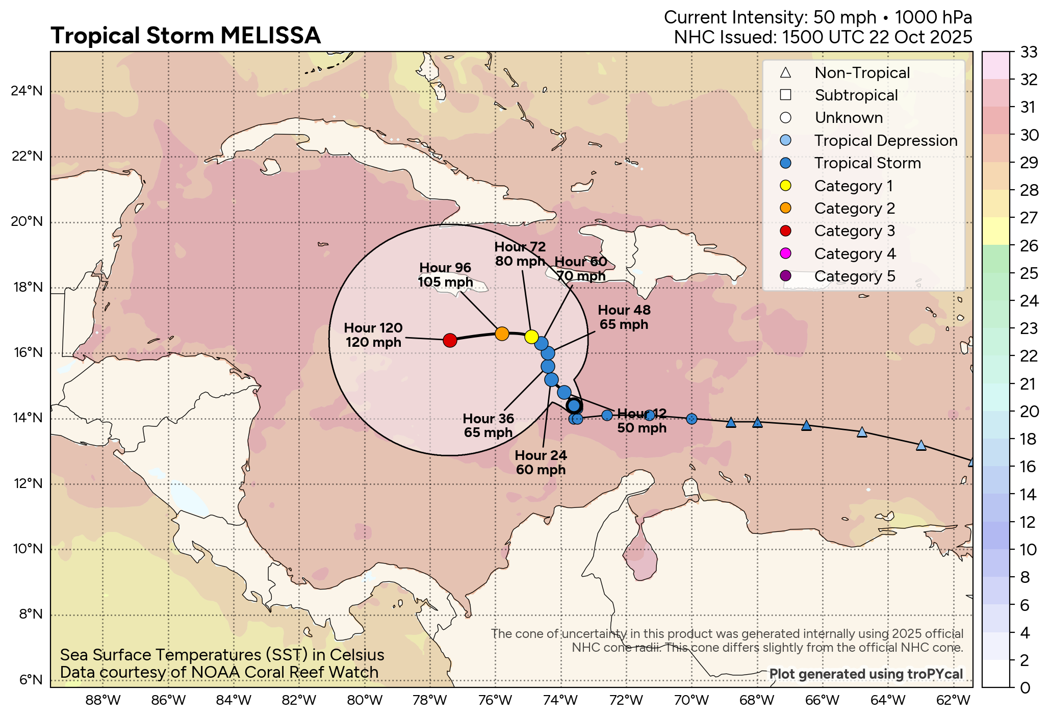
The government of Jamaica has raised a hurricane watch for what is currently tropical storm Melissa and with the National Hurricane Center warning that “significant strengthening is expected” and some forecast models showing a particularly intense storm nearing the island, it brings the country’s World Bank catastrophe bond and parametric insurance into focus.
 Update – Saturday Oct 25th: We’ve written a follow-up article as the Jamaica cat bond notes have been marked down and the latest NHC forecast shows the potential for a major hurricane landfall.
It’s important to state that there is meaningful uncertainty in the forecast model path and intensity projections for tropical storm Melissa at this time.
Some of the forecast models have struggled to get to grips with the expected trajectory Melissa will follow, but as time passes more consistency is being seen and some of the models now predict a very intense hurricane Melissa move near to or even over Jamaica by Sunday or into Monday.
The forecast model spread has been particularly wide, with some suggesting the storm would turn north through the Dominican Republic or Haiti, while others have been suggesting Melissa would meander slowly into the central Caribbean, where the sea surface temperatures are particularly high, where plenty of heat is available to fuel a very intense hurricane.
Yesterday, the models began to become more aligned, aside from the GFS which still opts for the more northerly movement. But as a pressure pattern to the north begins to exert more pressure on Melissa’s track, the majority are now forecasting tropical storm Melissa will head in Jamaica’s general direction and intensify rapidly as it moves west.
As a result, the latest update from NOAA’s National Hurricane Center today has highlighted the fact the government of Jamaica has now raised a hurricane watch for the island nation, while upgrading the tropical storm watch to a warning.
The NHC explained, “At 800 AM EDT (1200 UTC), the center of Tropical Storm Melissa was located by Air Force Reserve reconnaissance aircraft near latitude 15.5 North, longitude 74.9 West. Melissa is moving toward the northwest near 5 mph (7 km/h). A slow northwest or north motion is forecast during the next couple of days, followed by a westward turn over the weekend. On the forecast track, Melissa is expected to move closer to Jamaica and the southwestern portion of Haiti during the next couple of days.
“Maximum sustained winds are near 50 mph (85 km/h) with higher gusts. Little change in strength is expected during the next day or so, but significant strengthening is expected by late Friday and over the weekend. Melissa is forecast to become a hurricane in a couple of days.”
The NHC’s own forecast advisory data suggests that what will become hurricane Melissa could have maximum sustained wind speeds of more than 130 mph by October 28th, with gusts of 160 mph or higher.
That’s Category 4 level and some of the hurricane-specific forecast models are currently showing a very intense storm with a minimum central pressure in the low 900’s. In fact, some models show a central pressure deepening further, although those are models which can be overly-aggressive at longer lead times.
What is concerning is the fact the models that do take the storm west towards Jamaica do not show what could be a major hurricane Melissa moving forward very quickly, with some suggesting the island could face very strong and damaging winds for more than one day.
Also concerning are the forecasts for extreme rainfall levels and this combined with a slower moving storm could create significant and dangerous impacts for any land mass affected and its population.
The NHC forecasts 5 to 10 inches of rainfall through Sunday for Jamaica, as well as parts of the Dominican Republic and Haiti, with locally higher amounts. Some forecast models suggest accumulations could reach well above the 10 inch level.
Andrew Siffert, Senior Meteorologist at insurance and reinsurance broker BMS Group said it well in an update yesterday, “Tropical Storm Melissa is forecast to be a major Caribbean flood threat. Although there is forecast uncertainty in track and intensity, significant impacts are expected in Haiti, Jamaica, and Cuba in the next 10 days.”
It’s important to be cautious, with a good deal of uncertainty still in the forecasts for what could become a major hurricane Melissa and a number of days for the storm to intensify and adjust its path as it moves through the Caribbean.
But, with hurricane models suggesting a deepening storm whose central pressure gets down into the low 900’s, it does bring Jamaica’s range of parametric disaster risk transfer instruments into focus again.
Jamaica has a layered disaster risk financing and insurance program, with multiple instruments including CCRIF parametric insurance and the country’s World Bank facilitated $150 million parametric IBRD CAR Jamaica 2024 catastrophe bond transaction.
Were the model forecasts for a particularly intense major hurricane Melissa to prove correct and the storm to track very close to or over Jamaica, then some of these instruments could potentially face a threat of being triggered.
Update – Friday Oct 24th 08:00 BST: Hurricane forecast models continue to show an intense Category 3 or 4 hurricane Melissa tracking over Jamaica on Sunday and Monday, with a good number of models and runs currently showing a scenario that would almost certainly result in the IBRD cat bond being triggered in some way.
It’s worth noting that it is central pressure and location that matters, with Jamaica and the surrounding sea broken into parametric boxes for the IBRD cat bond’s trigger (more details on that can be seen in one of our articles related to 2024’s hurricane Beryl).
It’s also worth noting that we believe the lowest payout threshold is for a 30% triggering of the cat bond note principal, while a more intense storm can cause a full payout just for entering a single box. Parametric boxes can also be additive, in that if a storm passes through more than one the payout for each can get added together, under certain circumstances.
From a cat bond market perspective, the Jamaica World Bank cat bond is the only exposure to Melissa as long as it stays away from the United States, which is a very small proportion of the outstanding market. As well as parametric insurance under the CCRIF, Jamaican resorts and hotels also have some parametric coverages and there will be other market exposure perhaps to reinsurance as well as the primary market, were Melissa to cause meaningful impacts.
At this time, on Friday morning, Melissa remains a tropical storm and is almost stationary, with the NHC now warning of life threatening and catastrophic landslides and flash flooding across southern Hispaniola and Jamaica this weekend. Rapid intensification is forecast over the weekend with Melissa forecast to be a major hurricane close to Jamaica by Sunday.
Update – Friday Oct 24th 13:00 BST: Specialist catastrophe bond and insurance-linked securities (ILS) manager Twelve Securis said that it, “Acknowledges a potential impact on Jamaica’s World Bank Cat Bond and some parametric insurance exposures. The impact cannot be quantified at this stage, and we will reassess as more information becomes available.”
Twelve Securis also noted that, “If Melissa remains a Category 4 or 5 storm impacts across the north-central Caribbean are likely to be significant, on par with some of the region’s worst historical events. While some forecast scenarios do suggest Florida or north-east US impacts these are considered low-probability outliers and no impacts from Melissa are expected in the US based on current forecasts.”
Cat bond fund manager Icosa Investments AG also commented on Melissa, saying, “For cat bonds, we don’t anticipate broad market impacts as long as there is no U.S. landfall. The most acute exposure is a single parametric bond linked to Jamaica with a market weight of slightly less than 0.3%. Beyond that, market effects should remain limited unless the track or intensity changes materially.”
Plenum Investments, another cat bond specialist manager, has also commented, stating, “Tropical Cyclone “Melissa,” located south of Jamaica, poses an elevated risk to the island. While a potential landfall remains uncertain, flooding, landslides, and infrastructure damage are possible. As the storm intensifies, it could affect an IBRD CAT bond (market weight 0.28%). Given the current wide divergence in track forecasts, the expected level of damage remains unclear.
“A total loss would have corresponding impacts on our funds:
– Plenum Insurance Capital Fund: 0.0%
– Plenum CAT Bond Defensive Fund: 0.0%
– Plenum CAT Bond Dynamic Fund: 0.23%“As the overall impact of Tropical Storm Melissa on the CAT bond market appears limited and it is unlikely to make landfall along the U.S. coast, we will refrain from further communication on this event.”
But, again we have to highlight, there remains uncertainty, in both the intensity and the track Melissa will take. However it is worth bringing these parametric instruments into focus at this time, as they could become part of the recovery conversation for Jamaica, were a damaging or dangerous scenario to unfold with this storm over the next few days.
It is worth pointing out that there are model runs currently that show a scenario that would likely result in the activation of some or all of Jamaica’s layers of parametric disaster financing and insurance protection. But there are also plenty of model runs that show Melissa missing the island completely, or not intensifying as much as some runs predict.
There is also uncertainty in how Melissa tracks beyond Jamaica, with the Cayman Islands not far away from some modelled tracks, while Cuba may also be threatened by a hurricane as well.
Currently, only one model shows Melissa tracking further west and curving north and across Cuba not that far from the southern tip of Florida or the Bahamas. But that is seen as an outlier it seems, with most meteorologists currently suggesting the risk to the United States remains low. It is still early days though and any passage further south and west, or at a slower pace, could potentially elevate the risk to US interests. So Melissa will need watching.
Finally, it’s interesting to have seen that some of the artificial intelligence AI weather models had done a better job of predicting Melissa would move further south and west, with a path towards Jamaica, than some of the numerical models had managed.
![]() View all of our Artemis Live video interviews and subscribe to our podcast.
View all of our Artemis Live video interviews and subscribe to our podcast.
All of our Artemis Live insurance-linked securities (ILS), catastrophe bonds and reinsurance video content and video interviews can be accessed online.
Our Artemis Live podcast can be subscribed to using the typical podcast services providers, including Apple, Google, Spotify and more.


