


The eleventh named storm, tropical storm Karen, of the 2013 Atlantic Hurricane Season has formed in the southern Gulf of Mexico beween Cuba and Mexico and is forecast to become hurricane Karen before making landfall somewhere between New Orleans and the Florida Panhandle.
Tropical storm Karen is the first real threat to the U.S. coastline of the 2013 hurricane season. So far nothing has looked like threatening the U.S. coastline with anything approaching hurricane force winds. Karen may change that.
Tropical storm Karen, currently positioned in the southeastern Gulf of Mexico to the north of Cancun, already has maximum sustained winds of 65mph and this is forecast to increase as Karen moves rapidly into the open, warm waters of the Gulf.
Tropical storm Karen is currently expected to becomme hurricane Karen within the next 36 hours, by which time it will be in the central Gulf. The current forecast shows Karen then being downgraded again to a tropical storm, before making landfall around the Mobile, Alabama to Pensacola, Florida area. Don’t count on Karen weakening though, some forecasters believe landfall will happen as a hurricane, not a tropical storm, it’s too early to be complacent about this storm.

Tropical storm Karen (soon to be hurricane Karen) forecast path or track
Accuweather believe that wind shear along the U.S. coastline will prevent Karen from intensifying into a major threat. They expect Karen will make landfall as a strong tropical storm, bringing some damaging winds, heavy rainfall and some coastal flooding to wherever it makes landfall.
Karen is expected to make landfall sometime on late Saturday, local time. The graphic below from Accuweather shows the location of the wind-shear which the forecaster expects to prevent it intensifying into a really dangerous storm.
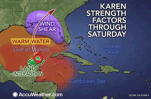
Tropical storm Karen and expected wind shear - Source: Accuweather
A hurricane watch is in effect from Grand Isle, Louisiana eastward to Indian Pass, Florida. A tropical storm watch is in effect from west of Grand Isle to Morgan City, Louisiana, so including metropolitan New Orleans, lake Maurepas and lake Pontchartrain.
The image below shows the main forecast models for tropical storm Karen, as well as the storms current position and the cone of uncertainty. The models all suggest a Gulf of Mexico landfall, so the question really comes down to where and how powerful will Karen be at landfall and also how strong the storm will be as it passes through key Gulf energy production areas.
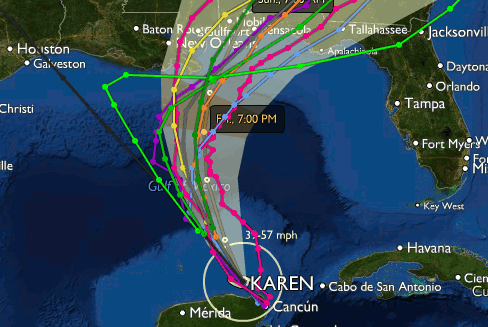
Forecast models for tropical storm Karen
The offshore energy sector, and offshore energy insurers, reinsurers and alternative capital with exposure in the Gulf, will be keeping a close eye on tropical storm Karen as the storm makes progress and intensifies into a hurricane. Karen will pass directly through the Central Planning Area of the Gulf of Mexico, which has some of the highest density of fixed and moveable rigs, platforms and associated machinery in the world.
Of course we now have a catastrophe bond in the market which contains exposure to offshore energy risks in the Gulf of Mexico. AIG’s Tradewynd Re Ltd. (Series 2013-1) cat bond provides cover for the insurers commercial book including items such as oil refining, chemical operations, power generation, utilities and power plants, mining above and below ground, construction coverage and offshore oil rig coverage for exploration and production of oil and natural gas.
The Gulf of Mexico is explicitly named as a region covered by the Tradewynd Re cat bond, and as well as offshore energy and engineering risks such as oil or gas exploration and drilling, the cat bond also covers some of AIG’s cargo, hull and recreational marine risks. So any storm now entering the Gulf of Mexico needs to be watched by investors in this cat bond.
Of course the alternative capital reinsurance market will also carry some exposure to Gulf risks, such as energy, through its participation in collateralized reinsurance contracts and industry loss warranties, as well as any cat-in-a-box type parametric covers for offshore U.S. wind.
We’ll keep you updated as tropical storm Karen intensifies, becomes a hurricane and heads towards the U.S. coastline. You can track Karen and every storm of the season on our 2013 Atlantic Hurricane Season page.
![]() View all of our Artemis Live video interviews and subscribe to our podcast.
View all of our Artemis Live video interviews and subscribe to our podcast.
All of our Artemis Live insurance-linked securities (ILS), catastrophe bonds and reinsurance video content and video interviews can be accessed online.
Our Artemis Live podcast can be subscribed to using the typical podcast services providers, including Apple, Google, Spotify and more.


