


The U.S. National Weather Service (NWS) Storm Prediction Center is warning of an outbreak of dangerous tornadoes, severe thunderstorms, large hail and high winds for parts of the southern Plains, with a particular focus around north Texas to Oklahoma City.
The NWS explains, “An outbreak of tornadoes, some potentially long-track and violent, is expected today into this evening over portions of northwest Texas into western and central Oklahoma. More isolated but still potentially dangerous severe weather, including tornadoes and destructive winds and hail, is possible in surrounding parts of Texas, Oklahoma, Kansas, and Arkansas.”
As ever, for the insurance, reinsurance and insurance-linked securities (ILS) markets, the exposure to such events can be significant when urban areas, towns, cities and metros are hit by this kind of weather.
It’s also important to remember that hail has been the major driver of insurance and reinsurance market loss from severe convective weather in the United States for most years in recent history, but that’s not to downplay the damage that can also be caused by rainfall induced flash flooding and other related perils as well.
Of course tornado damage is the really destructive peril among the convective weather grouping and the NWS uses particularly strong language in explaining the risks it sees in the southern Plains, north Texas into Oklahoma in particular, area.
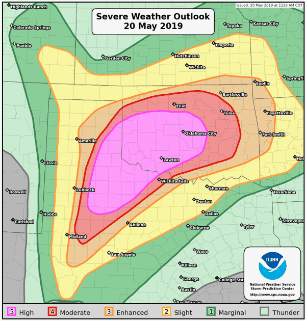
Much of Oklahoma could be affected by the severe weather outbreak, along with Northwest Texas and the eastern Texas Panhandle and the weather service warns of numerous intense and long-track tornadoes, widespread damaging winds, some hurricane force, as well as widespread large hail, some of baseball size.
“A serious outbreak of destructive, tornadic supercells is likely over parts of this region this afternoon into evening, especially in the high- and moderate-risk areas,” the NWS wrote in its warning today. The NWS has warned of a “particularly dangerous situation” developing.
A significant level of severe weather activity is expected today as a result and so it’s worth keeping an eye on the NWS website as this dangerous situation develops.
It’s also worth keeping an eye on our U.S. severe thunderstorm page which offers warning graphics, trend data and other useful information for assessing the threat level at any time during the year.
———–
 Register today to attend our next ILS conference in Singapore, ILS Asia 2019.
We’re returning to Singapore for our fourth annual ILS market conference for the Asia region. Please register today to secure the best prices. The last few Early Bird tickets are still available.
![]() View all of our Artemis Live video interviews and subscribe to our podcast.
View all of our Artemis Live video interviews and subscribe to our podcast.
All of our Artemis Live insurance-linked securities (ILS), catastrophe bonds and reinsurance video content and video interviews can be accessed online.
Our Artemis Live podcast can be subscribed to using the typical podcast services providers, including Apple, Google, Spotify and more.


