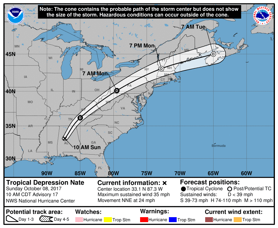
Hurricane Nate remains on course for the United States Gulf Coast, where forecasts predict it will make landfall as a strong hurricane. Nate currently has 90 mph winds and higher gusts, with central pressure of 982mb (at 06:00 PM UTC Oct 7th), and the storm could intensify further before landfall somewhere from Louisiana to Florida.
There remains some uncertainty over precisely how strong hurricane Nate will become, as it tracks through the Gulf of Mexico over the next 24 hours or so. But the National Hurricane Center (NHC) warns, “Additional strengthening is expected through Saturday up until the time Nate makes landfall along the northern Gulf coast.”
It’s destined now to increase the insurance and reinsurance industry losses from hurricanes in 2017, with a number of catastrophe bonds also now exposed and ILS or collateralized reinsurance positions as well.
The main threat for ILS will be to collateralized reinsurance or retrocession, as well as any aggregate catastrophe bonds, which could now be adding a fourth industry loss report to their aggregates. If Nate’s impact is at all severe a good number of these aggregate retro cat bonds may be at-risk of loss.
Hurricane Nate is the fourteenth named storm and ninth to become a hurricane, of the 2017 Atlantic season , and the forecast landfall and strengthening is sure to have some in the reinsurance, catastrophe bond and ILS sector rightly concerned after recent events.
Hurricane Nate’s forecast path takes the storm towards a landfall on the Gulf Coast around the Louisiana to Florida section of the northern coast, with cities from New Orleans to Pensacola all at risk of potential hurricane force winds and a storm surge.

Tropical storm Nate forecast to take a path towards the Gulf Coast as a hurricane
Following the impacts of hurricanes Harvey, Irma and Maria on reinsurance, catastrophe bond and ILS markets, the prospects of a fourth hurricane landfall will be concerning to many in the industry this weekend. It raises all sorts of questions of reinsurance coverage; is there enough, whether it has been reinstated, how many storms it covers etc.
At least 22 deaths have been reported in Costa Rica, Nicaragua and Honduras, after heavy rains, landslides and flooding struck the region. Further torrential rainfall struck the Yucatan area of Mexico and Gulf of Mexico oil platforms have been evacuating workers before Nate’s approach.
Nate reached hurricane status rapidly after passing the Yucatan and now is forecast to intensify somewhat further on approach to the coast, with some suggesting a landfall is likely to feature a hurricane with 90 mph or stronger winds.
That’s sufficient for a reasonable sized insurance and reinsurance industry loss, enough to worsen the already negative quarter many reinsurers and ILS funds are facing.
There remains some uncertainty in the intensity forecast for hurricane Nate at this time, but the main obstacles to future development are now passed and with Gulf of Mexico SST’s sufficient for some intensification there is every chance of a strong hurricane landfall in the Louisiana to Alabama (even Florida panhandle) stretch of coastline.
Most forecast model runs continue to center on the Louisiana coast, just to the east of New Orleans currently, but the track could curve more bringing hurricane Nate into Mississippi, Alabama or even Florida.

Tropical storm Nate forecast models - From Tropicaltidbits.com

Tropical storm Nate intensity model guidance - From Tropicaltidbits.com
It’s expected that hurricane Nate will continue to move rapidly towards landfall, reaching the Gulf Coast tonight, Saturday, or in the early hours of Sunday morning.
Hurricane Nate will bring significant rain to the region, including New Orleans which still does not have fully working drainage pumps following floods earlier this year.
Maximum rainfall totals of around 10 inches are expected along hurricane Nate’s path, with the speed of the storms progress likely to at least lessen rainfall impacts slightly.
Storm surge is a real threat, with the following forecast currently:
– Mouth of the Mississippi River to the Mississippi/Alabama border…7 to 11 ft
– Mississippi/Alabama border to the Alabama/Florida border, including Mobile Bay…6 to 9 ft
– Morgan City, Louisiana to the mouth of the Mississippi River…4 to 6 ft
– Alabama/Florida border to the Okaloosa/Walton County Line…4 to 6 ft
– Okaloosa/Walton County Line to Indian Pass, Florida…2 to 4 ft
– Indian Pass to Crystal River, Florida…1 to 3 ft
Corelogic said that over 76,000 U.S. homeowner properties are at risk of storm surge damage from hurricane Nate in Louisiana, Mississippi, Alabama and Florida, with the estimated reconstruction cost put at $16 billion.
The reinsurance and ILS market will not enjoy the worsening forecast and hurricane Nate threatening the Gulf Coast could stimulate some live cat protection buying today, particularly if intensification proves more rapid than anticipated. Some companies could find themselves a little lacking in certainty over protection layers of reinsurance or ILS coverage that have been impacted by the severe 2017 season already.
All of the tracking maps and graphics on this page will update automatically as hurricane Nate approaches the U.S. Gulf Coast.
 View all of our Artemis Live video interviews and subscribe to our podcast.
All of our Artemis Live insurance-linked securities (ILS), catastrophe bonds and reinsurance video content and video interviews can be accessed online.
Our Artemis Live podcast can be subscribed to using the typical podcast services providers, including Apple, Google, Spotify and more.


