


European windstorm Xaver has now begun to dissipate, having impacted many northern European countries and caused widespread damage from high winds, which reached hurricane force and above, as well as the worst storm surge seen in 60 years.
It’s still far too early to predict the level of insurance industry losses from windstorm Xaver, but more information and insight continues to emerge from risk modelling firms and scientists which helps to give a better picture of the potential losses that Xaver will undoubtably cause.
Here’s our first article on Xaver, which provided updates during the storm’s approach and impact. Also read our article from yesterday where we revealed that independent provider of industry-wide European catastrophe insurance loss data and indices PERILS AG would assess whether European windstorm Xaver was likely to cause a large enough insured loss to qualify for reporting under its methodology.
So, first here is the latest update from risk modelling firm AIR Worldwide:
Extratropical Cyclone Xaver Moves Slowly Across Europe with Powerful Winds and Storm Surges
BOSTON, Dec. 6, 2013 – According to catastrophe modeling firm AIR Worldwide, Extratropical Cyclone Xaver has moved across Germany, the Netherlands, Denmark, and Poland. Wind speeds were recorded at 158 km/h when the storm reached Germany and heavy winds affected the Netherlands, Poland, and parts of Scandinavia. Massive storm surges have occurred along the coasts of southeastern England, the Netherlands, and northern Germany.
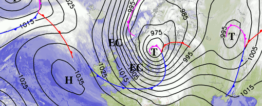
“Xaver developed off the coast of Greenland on December 4, 2013 and its development was enhanced by another low-pressure system, Wilhelm, which was located over the Norwegian Sea on December 4–5,” said Dr. Nicolai Thum, senior research associate, AIR Worldwide. “Xaver passed north of Scotland on December 5, where its central pressure had dropped to 975 mb from a reading of 1010 mb less than 24 hours earlier. A pressure drop of this type, which deepens by 24 mb or more over 24 hours, often produces a phenomenon known as rapid cyclogenesis (or a weather “bomb”). Heavy winds were transported closer to ground level, bringing with them heavy precipitation and thunderstorms. By the morning of December 5, pressure levels had dropped 17 mb in three hours near Lerwick, Scotland, while it increased 18 mb over Sule Skerry. Later that day, over Thyboroen, Denmark, a pressure drop of over 14 mb in three hours was observed.”
Overnight, Xaver continued moving across the North Sea and reached northern Europe, packing strong winds, massive storm surges, rain, and snow. In Germany, wind gusts of up to 174 km/h were recorded at the North Sea island of Sylt, while sustained winds were 148 km/h. Wind speeds as high as 158 km/h struck Gluecksburg-Meierwik and reached as far inland as Brocken. Other recorded wind speeds include 148 km/h at the island of Spiekeroog, 144 km/h at Fichtelberg and Leuchtturm Kiel, 140 km/h at Strucklahnugshoern (Nordsee), and 137 km/h at Rostock, Warnemuende, and Buesum. Northern Poland received wind speeds as high as 160 km/h, while similar gusts were reported in parts of the Czech Republic.
Dr. Thum continued, “The greatest threat from Xaver has been the high spring tides, which along with Xaver’s slow track have enhanced storm surges on Thursday and Friday. The storm surge in the United Kingdom and the Netherlands is the highest seen since the deadly North Sea floods of 1953; however, disaster has been averted thanks to strengthened flood defenses in both countries.”
In England, the Thames Barrier will be closed for the second time in two days in accordance with the tide, preventing the surge from reaching London as it did in 1953. Xaver’s surge caused a difference of two meters in water height between the front and back of the barrier.
Flood defenses in the Netherlands successfully held back the rising water by closing off the Eastern Scheldt barrier for the first time since 2007. In southwestern Zeeland, the sea reached 3.99 m above mean sea level. Germany is comparing Xaver to the 1962 floods, which submerged nearly a fifth of Hamburg’s municipal area with water 5.7m above mean sea level. Xaver’s storm surge reached 4–6m above mean sea level. However, the area has fared far better thanks to Germany’s 8m dikes.
The storm is slow moving and the relentless battering from winds can weaken structures, increasing their vulnerability. A sea cliff in Hemsby, England, collapsed on Friday, causing several homes to tumble into the sea. Extreme flooding was seen along several communities in southeastern England including Whitby, where about 100 homes received over a meter of water. Lowestoft, Whitby, Great Yarmouth, and Saltburn also experienced flooding. Storm surges along western Great Britain affected several cities including Blackpool. Flood defenses failed at the English cities of Lincolnshire and Boston.
Roof damage is widespread and fallen trees have damaged homes and autos. Railways, roads, and bridges have been closed due to strong winds, high water and debris.
According to AIR, most of the residential buildings in the United Kingdom are detached, semi-detached, or terraced (row) houses and are primarily of masonry construction. Single-family homes in Germany, Denmark, the Netherlands, and Poland, are also predominantly of masonry construction, although a small percentage are wood frame, and are mostly low-rise. Sweden’s building stock has a much higher percentage of wood frame buildings. Mid-rise residential buildings generally have exterior non-load bearing walls made of masonry although they may have light-gauge steel stud walls or concrete panels. Under high winds, most of the damage in built up areas is to rooftops and chimneys of residences, although walls are often damaged by flying debris.
Floods can affect a significant portion of low- and mid-rise buildings, particularly the cellars. Risk is particularly high for finished cellars with furniture and appliances; some may contain entire apartments. Usually, heavily used cellars have better flood defense mechanisms than unfinished ones. Large apartment and condominium buildings often have a higher level of engineering and are more resistant to wind damage. Wind damage ratios for tall buildings are lower because the roofs are a smaller portion of the building as a whole. However, balconies, awnings, and sliding glass doors are susceptible to wind damage.
According to AIR, commercial exposures use a wider variety of construction types. Smaller buildings are usually masonry and perform similarly to residential buildings under strong winds. Larger buildings are generally reinforced concrete or steel, and wind damage is typically to nonstructural components such as mechanical equipment, roofing, cladding, and windows. Large commercial buildings often have a large amount of external glass, which is quite vulnerable to wind damage. Flood vulnerability is usually mitigated by flood defenses, although lower floors and cellars often contain services, fixtures, and electrical and mechanical fittings.
As of 15:00 GMT, December 6, 2013, Xaver is stationary over the Baltic Sea and winds are still impacting a wide region. The winds are dissipating and the storm is expected to end later today. AIR is monitoring this storm closely and will provide updated information next week.
Here is the latest update from risk modelling firm RMS, which focuses on the fact that the storm surge flooding could have been much worse had it not been for greatly improved flood defences:
Brian Owens, senior director and meteorologist at RMS says, “Windstorm Xaver has brought strong winds and significant surge to parts of northern Europe. Compared to the significant Europe surge events observed in the past, however, Xaver might not produce as significant impacts. The duration of strong winds that are building up the surge are shorter than past events and surge heights will likely not be as large. Combined with the enhanced defenses, most developed regions are likely to be safe from its impact.”
Windstorm Xaver Characteristics
Coastal surge is dependent on the central pressure and winds of the storm. The most significant component is the wind, particularly its strength, duration and direction, which combine to influence the size of the surge experienced.
Xaver represents a classic surge setup as the storm tracked in from the Atlantic, over the north of Scotland and directly down the North Sea towards the continent. The combination of strong winds acting on the underlying water in a southeast direction over a long duration pose a significant surge threat, as water is driven towards the coast and funneled by the morphology of the coastline.
The timing of storm surge is a key determining factor in the scale of the damage. Surge impacting a region at local high tide poses the greatest risk for flooding. Low lying areas and exposed locations, such as ports and quays are potentially at most risk.
As the storm surge approaches the coast, it interacts with the local astronomical tide, amplifying the water level experienced locally. Consequently, the timing of the surge is also a determining factor in scale of the hazard. A surge impacting a particular region at local high tide poses the most risk for flooding. Low lying areas and exposed locations, such as ports and quays are potentially at most risk.
Historical Data
The UK, Netherlands and Germany have experienced significant surges in the past. In 1953 a devastating surge impacted, in particular, the UK and Netherlands, claiming over 2,100 lives and flooding approximately 2,500 square km (950 square miles). In 1962, a strong surge impacted northern Germany, particularly Hamburg, claiming over 350 lives, flooding extensive areas as dykes breached.
In response to these past events significant investments were made to develop defenses over large portions of the European coastline. Since these improvements, significant surge impacts have generally been mitigated. However, for poorly maintained defenses or those not designed to defend against significant storms, a surge occurring in conjunction with high tide poses a significant risk of defense over-topping or potential failure.
RMS provides a storm surge modeling solution for the east coast of the UK, as part of it’s European windstorm model. Events such as those in 1953, 1962 and Xaver are represented by this surge model, helping the (re)insurance industry to evaluate their potential storm surge risk.
Finally, Aon Benfield’s catastrophe modelling division Impact Forecasting provided a detailed update on windstorm Xaver in their latest weekly catastrophe update report. We reproduce their update below:
Windstorm Xaver tracks through Northern Europe
Windstorm Xaver developed this week and quickly tracked across northern Europe, leaving at least 11 people dead and dozens of others injured. The storm brought hurricane-force winds, heavy rains, severe thunderstorms, and a coastal storm surge from the United Kingdom to Scandinavia on Thursday into early Friday. Early reports indicate that the storm caused widespread damage and more than 650,000 power outages in several countries. Xaver becomes the second notable windstorm to strike Europe in the last six weeks.
Meteorological Recap
An extratropical area of low pressure rapidly began to develop over the North Atlantic during the day on Wednesday as it quickly tracked eastward. Given the intensification and projection of tracking into northern Europe, the Free University of Berlin dubbed the storm “Xaver”. By late Wednesday into early Thursday, the system continued to undergo significant deepening as it began to approach northern sections of the United Kingdom. Further strengthening commenced as Xaver crossed the North Sea during the day on Thursday and the minimum central pressure dropped to an estimated 962 millibars (28.41 inches of mercury) while entering parts of Scandinavia. The storm continued to intensify on Thursday night into early Friday while moving through Scandinavia. Xaver was forecast to weaken on Friday and Saturday as it shifts further into Eastern Europe.
Prior to Xaver’s arrival, meteorological agencies throughout Europe issued various wind, storm surge and flood warnings. Forecast computer model projections anticipated sustained winds of up to 110 kph (70 mph), with gusts in excess of 150 kph (90 mph) in Denmark, the Netherlands, Belgium and Germany. The storm’s trajectory also led to the risk of a significant storm surge. Initial surge projections suggested that heights would be the worst in 60 years in the United Kingdom; the worst in 30 years in Belgium; and the worst in 51 years in northern Germany. Adding to the coastal surge concerns was the prospect of Xaver coming ashore and coinciding with high tide.
Several oil and gas producers in the North Sea (including ConocoPhillips, Maersk Oil, and Statoil cut production and evacuated staff from platforms.
Damage Details
United Kingdom
The first areas to report damage came in the United Kingdom, particularly in Scotland – where at least two people were killed. At least 100,000 Scottish Hydro Electric and Scottish Power customers lost electricity as winds gusted in excess of 150 kph (90 mph). A peak gust of 228 kph (142 mph) was recorded just outside of Fort William in the Scottish Highlands. Fire officials received hundreds of calls for help citing fallen masonry, fallen trees and damaged buildings, and very dangerous road conditions caused difficulties for emergency officials trying to reach some areas. Also, all train service was halted in Scotland on Thursday morning due to significant debris and track damage. Glasgow Central Station was evacuated at the peak of the event due to flying debris causing the partial collapse of its glass roof. Additional damage was reported to the roof at Glasgow’s Southern General Hospital.Elsewhere, more than 29,000 customers lost electricity in Ireland following winds gusting in excess of 110 kph (70 mph) that caused sporadic damage to the electrical grid. Waves up to 9.0 meters (30 feet) in height battered coastal sections of Wales, where sea water penetrated through makeshift blockades into the town of Rhyl. Similar wave heights were registered in England’s coastal town of New Brighton in Merseyside County. British officials evacuated more than 10,000 homes in Norfolk, Suffolk and Essex due to a severe risk of coastal flooding, and at least 1,000 properties later reported flood damage. Several homes also collapsed into the sea at Hemsby. Throughout the UK, the Environment Agency issued more than 238 flood warnings and alerts, including 41 warnings labeled as “severe” – which signified danger to life. Heavy rains associated with Xaver also caused several rivers to overflow their banks (such as the Humber, Tyne and Tees).
Based on data from the UK Met Office, some communities along the North Sea coast from Northumberland to the Thames Estuary and Kent – in addition to communities on the Irish Sea coast from Cumbria to Chesire – registered their highest storm surges since 1953. (During the 1953 event, more than 300 people were killed by massive flooding.) However, despite the level of damage sustained by Xaver, the development of flood protection in the decades following the 1953 floods substantially minimized the overall impacts. Most notably, barriers along the Thames and Hull rivers performed well during Xaver. The Thames Barrier was closed twice to protect London from a potential flood risk.
Germany
The German Weather Service issued an “Extreme Weather Warning” for the northern states of Hamburg, Schleswig-Holstein, Lower Saxony, and Bremen as Xaver brought winds gusting to158 kph (98 mph) to a wide swath of coastal and inland locations. On Germany’s North Sea island of Sylt, a gust of 174 kph (108 mph) was recorded. One fatality was attributed to the storm. The greatest concern was for coastal flooding, as a storm tide of 3.7 meters (12.1 feet) above normal high tide struck the city of Hamburg – the second-highest tide ever recorded in the city. At Bremerhaven, storm surge peaked at 4.0 meters (13.1 feet) though it occurred at low tide, which minimized the flood threat in the city. Since the historic flood events in 1962 and 1976, an extensive flood protection system with coastal dikes was built to withstand water levels up to 8.0 meters (26.0 feet) along coastal Germany. These barriers helped minimize impacts from Xaver, in addition to the closure of 38 flood gates in Hamburg. Flooding was reported in two small, low-lying islands in the North Sea (Langeness and Hooge) though damage was not considered extensive.Given Xaver’s trajectory and speed, the storm’s impacts were felt across multiple tide cycles that caused tidal waters to flow into the Elbe River. Multiple locations along the river recorded elevated water levels, including in Hamburg, where water up to 6.0 meters (19.7 feet) flooded the city’s fish market and many roads. The inclement weather led to school and business closures, including several industrial plants.
In terms of transportation, flights were cancelled at airports in Hamburg, Cologne and Duesseldorf, train service via the national railway Duetsche Bahn was restricted, and ferries to/from Germany’s North Sea islands were suspended. The port of Hamburg was closed overnight Thursday into Friday but reopened.
The deadliest flood of the last 100 years in Germany occurred in February 1962 following the arrival of a powerful windstorm. At least 340 people were killed after the failure of several protective dikes that flooded nearly one-sixth of the city of Hamburg.
Netherlands/Belgium
The Netherlands closed multiple water barriers to protect low-lying coastal sections of the country from storm tides, including the Oosterscheldekering for the first time since 2007. A peak water height of 3.99 meters (13.1 feet) above normal sea level was recorded in the coastal province of Zeeland, which was the highest level registered since 1953. However, flood damage in the country was not as catastrophic as feared though everal areas of Rotterdam, Dordrecht and Maasluis reported up to knee-high floodwaters. At Botlekbrug, a temporary dyke along the Oude Maas River broke which flooded several roadways. Emergency service officials reported that 3,700 damage reports were made nationwide. The Netherlands is particularly vulnerable to coastal flooding given that 27% of the country lies below sea level.A preliminary estimate by Dutch insurers noted damages of at least EUR10 million (USD14 million), but this does not include any damage caused by flooding.
Belgium officials evacuated residents in low-lying areas, as a significant storm tide was forecast. However, impacts were on the same order as the Netherlands.
Scandinavia
At least three fatalities were recorded in Scandinavia (two in Denmark and one in Sweden), as winds gusted up to 148 kph (92 mph) along coastal locations. Two additional fatalities were recorded just off the coast of Sweden after the individuals were swept overboard off a ship. Most of the damage in Scandinavia was due to high winds causing roofs to partially be ripped off and trees to be downed. However, coastal flooding was prevalent in many areas, such as Sweden’s Helsingborg. More than 50,000 power outages were recorded in Sweden, and tens of thousands more in Norway and Denmark. Air transport was severely disrupted in Sweden, Denmark and Norway, as upwards of 500 flights were cancelled or delayed – including 200 alone at Copenhagen’s international airport. The Oeresund road and rail bridge connecting Sweden and Denmark was closed overnight on Thursday but later reopened early on Friday.Poland
Four people died, including three who were killed in the village of Poraj following a tree falling onto a car. Winds from Xaver reached 135 kph (85 mph) throughout much of northern Poland, which caused widespread tree and roof damage. Polish firefighters responded to more than 1,500 damage reports. The high winds also led to more than 400,000 customers losing electricity.In Austria, one person was killed after high winds blew a bus into oncoming traffic in Salzburg Province.
Financial Loss
Given the ongoing nature of the event, it remains too early to provide an economic or insured loss projection.
We’ll continue to update you next week as the early estimates of economic and insurance industry losses from European windstorm Xaver emerge.
![]() View all of our Artemis Live video interviews and subscribe to our podcast.
View all of our Artemis Live video interviews and subscribe to our podcast.
All of our Artemis Live insurance-linked securities (ILS), catastrophe bonds and reinsurance video content and video interviews can be accessed online.
Our Artemis Live podcast can be subscribed to using the typical podcast services providers, including Apple, Google, Spotify and more.


