


Super typhoon Hagupit, or typhoon Ruby as the storm is known in the Philippines, is bearing down on the Philippines with wind gusts estimated as high as over 200mph and a path that looks ever more likely to take it directly over the country.
Latest position of super typhoon Hagupit (Ruby):
Super typhoon Hagupit (Ruby) position, forecast path, track and intensity - Source: Weather Underground
Latest updates:
Update at 8th December, 05:00 EST, 10:00 GMT
The latest update from the Reuters news agency:
Philippine capital braces for storm, as Hagupit leaves 21 dead
The death toll from Typhoon Hagupit rose to 21 on Monday, the Philippine Red Cross said, after the storm tore through the country’s central islands flattening homes and toppling trees and power lines.
The capital Manila shut down as Hagupit, now downgraded to a tropical storm, took aim at the tip of the main island Luzon, just south of the city of 12 million people.
“We have confirmed reports that 21 people died in Eastern Samar, 16 of them in Borongan,” said Gwendolyn Pang, secretary-general of the Philippine Red Cross. Most of those killed were drowned in floodwaters, she said.
But despite the jump in the number of reported dead, there was relief that Hagupit had not brought destruction on the scale of super typhoon Haiyan, which last year killed thousands of people in the same areas of the central Philippines.
Hagupit roared in from the Pacific as a Category 3 typhoon on Saturday night, churning across Samar island and on to the smaller island of Masbate. Its effects were felt across the central Philippines, including Leyte island and southern Luzon.
Learning lessons from Haiyan, which left more than 7,000 dead or missing, the authorities had launched a massive evacuation operation ahead of the storm, emptying whole towns and villages in coastal and landslide prone areas.
“We saw that with preparation and being alert we prevented tragedy and harm, we took our countrymen away from harm,” Interior Secretary Manuel Roxas told a televised government disaster meeting in Samar. “It is sad to hear news of deaths, but this is very low, way below what the potential was.”
The Philippine weather bureau said Hagupit had weakened after making three landfalls, but was still packing winds of 105 kph (65 mph), with gusts of up to 135 kph (83 mph).
It was on course to hit Batangas province, around 90 km (55 miles) south of Manila, on Monday evening, and would later cross Manila Bay about 50 km west of the city.
Financial markets, schools and some public offices in the capital were closed and people in low-lying areas and near waterways were moved to shelters. Soldiers and emergency workers were put on standby to respond to any contingency.
CLEAR-UP OPERATION
Despite the relief that Hagupit had not been as devastating as was feared, a major operation remained to clear debris and get supplies to people left homeless or without power after the typhoon flattened houses and tore down power lines.
Delia Monleon, mayor of Jipapad, a town of 7,000 people in Eastern Samar province, said floodwaters were still preventing people from getting to their homes.
“Our problem is power, food is a problem because boats cannot leave,” said Monleon. “It was flooded yesterday so we can’t leave to look for food,” she said.
Proceso Alcala, the farm minister, said initial reports put crop and farm infrastructure damage at 1 billion pesos ($22 million). Rice crops were most affected, with little damage to corn.
Alcala said the state grains agency was considering importing an additional 600,000 tonnes of rice to boost buffer stocks after 48,000 tonnes of unmilled rice was damaged.
Mayor Emiliana Villacarillo of Dolores, in Eastern Samar, the area where Hagupit first made landfall, said almost 100 percent of ricelands in the town were submerged by floodwaters.
“Our farmers will have to go back to square one and plant again. We will need new seedlings,” she said.
Armed forces chief of staff General Gregorio Catapang told a news conference two C-130 planes loaded with supplies, including food and water, flew on Monday to Borongan, Eastern Samar, after soldiers had cleared three airports, including Tacloban City.
More than 48,000 residents of Tacloban had fled to shelters, but damage to the city that was devastated by Haiyan in November last year was relatively minor.
“A lot of them have begun to go home. In Tacloban this morning, the sun is shining, people just started going back,” said Orla Fagan, spokeswoman and Asia-Pacific advocacy officer at the UN Office for the Coordination of Humanitarian Affairs.
(Additional reporting by Neil Jerome Morales; Editing by Jeremy Laurence and Alex Richardson)
Here’s the latest update from Aon Benfield’s Impact Forecasting risk modelling unit:
Update at 21:00 Central time, 7th December.
COORDINATES: 13.3° north, 122.7° east (previous location: 11.9° north, 124.7° east)
LOCATION: 235 kilometers (145 miles) southeast of Manila, Philippines
MOVEMENT: northwest at 11 kph (7 mph) (previous: west at 13 kph (8 mph))
WINDS: 110 kph (70 mph) with gusts to 140 kph (85 mph) (previous: 165 kph (105mph))
RADIUS OF TROPICAL STORM-FORCE WINDS: 195 kilometers (120 miles)
SAFFIR-SIMPSON SCALE RANKING*: Tropical Storm1st LANDFALL DETAILS
LANDFALL LOCATION: Dolores Municipality, Quezon Province, Philippines
LANDFALL TIMEFRAME: 09:15 PM local time (PHT) – 13:15 UTC
LANDFALL INTENSITY: 205 kph (125 mph) – Category 32nd LANDFALL DETAILS
LANDFALL LOCATION: near Caitaingan, Masbate Island, Philippines
LANDFALL TIMEFRAME: 11:00 AM local time (PHT) – 03:00 UTC
LANDFALL INTENSITY: 155 kph (100 mph) – Category 23rd LANDFALL AND LOSS PROBABILITIES
LANDFALL LOCATION: Calabarzon Province, Luzon Island, Philippines
LANDFALL TIMEFRAME: Monday morning, local time
24-HOUR SIGNIFICANT LOCAL INSURED LOSS POTENTIAL: LOWDISCUSSION
Tropical Storm Hagupit, located 235 kilometers (145 miles) southeast of Manila, Philippines, is currently tracking northwest at 11 kph (7 mph). Satellite imagery shows fragmented banding along the northern half of the system, as the system has continued to deteriorate and weaken during the past 12 hours. However, there does remain some thunderstorm convection wrapping into the low-level circulation center. The JTWC has lowered the initial intensity estimate to tropical storm status with 110 kph (70 mph) maximum sustained winds based on an overall assessment of Dvorak current intensity estimates from all reporting agencies and the current overall structure of the system. Upper-level atmospheric analysis indicates that Hagupit remains in an area of moderate vertical wind shear that is partially offset by robust northward outflow. The system is currently tracking along the southwestern periphery of a ridge of high pressure located to the northeast.Hagupit will continue to track west-northwestward during the 24 to 36 hours under the steering influence of the ridge to the northeast. After this time, the storm is forecast to emerge into the South China Sea. On Wednesday morning (local time), Hagupit is expected to shift west-southwestward as ridging builds into the northern portion of the South China Sea. The cyclone will continue its weakening trend across the South China Sea as it interacts with the cooler and more stable air associated with the surge event in the North East Monsoon.
After 72 hours, Hagupit is expected to maintain a west-southwestward track across the South China Sea. The system will weaken rapidly as it approaches the southern coast of Vietnam. With the exception of one model, the overall guidance remains in tight agreement and there is high confidence in the JTWC forecast track.
Damage Details
Preliminary reports from the Philippines’ National Disaster Risk Reduction and Management Council (NDRRMC) indicate that there have been at least three fatalities due to Typhoon Hagupit. Government officials ordered one of the largest mass evacuations in the country’s recent history, with nearly 1.07 million people currently in evacuation centers. Two states of calamity have been declared thus far, including in the provincial regions of Albay and Camarines Sur.Early indications suggest that the level of damage from Hagupit is far lower than what was experienced from Super Typhoon Haiyan in November 2013. It will be several days and weeks until the local and federal officials are able to take a complete assessment of the affected areas, though the number of homes and businesses affected appears to be substantially lower. As of this writing, the primary threat to the Manila metropolitan region will be heavy rainfall that could lead to flooding and landslides given Hagupit’s slow track through the archipelago. However, power outages are widespread as 16 provinces in five regions are currently coping with minimal electricity. Nearly two-dozen national roads have been damaged and are inaccessible; while 183 domestic flights have been cancelled.
Update at 7th December, 09:00 EST, 14:00 GMT
Typhoon Hagupit is now located in the central Philippines having struck Samar island with winds of 100mph+. The evacuation strategy that saw hundreds of thousands of people moved away from coastal and exposed areas appears to have been successful in minimising the human toll from this typhoon, thankfully.
Rainfall is now the major threat as forecasters expect rainfall totals as high as 700mm from Hagupit. The typhoon will come very close to metro Manila at which stage it will be moving very slowly, exacerbating the impacts of rainfall and making flooding a definite threat to property and lives.
An update from the Reuters news agency:
Homes flattened as typhoon roars through Philippines
A powerful, slow-moving typhoon ripped through the central Philippines on Sunday, bringing howling winds that flattened houses and toppled trees and power lines in areas still scarred from a deadly super-storm just over a year ago.
In the coastal villages of Dolores, on Samar island, where Typhoon Hagupit first made landfall on Saturday night, Mayor Emiliana Villacarillo said around 80 percent of homes were destroyed.
“Only the big houses were left standing,” said Villacarillo, adding floods also washed away rice crops in what is a key growing region.
Officials confirmed at least three people had died due to the typhoon, including a resident of Dolores town who was killed by a falling coconut tree.
“The devastation in homes is huge because of the strong winds,” Interior Secretary Manuel Roxas told local radio DzBB from Samar. “Many people voluntarily returned to evacuation centers tonight, even more than those who fled to centers last night, because they do not have homes anymore.”
But Hagupit did not appear to have wreaked destruction on the same scale as last year’s super typhoon Haiyan, in part because of a massive operation to evacuate residents from coastal and landslide-prone areas days before the storm hit.
More than 1.2 million people had crowded into over 1,500 schools, civic centers, town halls, gyms and churches used as evacuation centers across the central Philippines, said Gwendolyn Pang, secretary general of the Philippine Red Cross.
Roxas said rescue teams cleared the highway to Dolores town of about 25 to 30 huge fallen trees. Some residents lined streets asking for food, water and other supplies.
Hagupit, which days earlier had reached category 5 “super typhoon” strength as it churned across the Pacific Ocean, weakened on Sunday to category 2 as it made a second landfall at Cataingan town in the south of Masbate island.
There were no initial reports of the kinds of storm surges that were so destructive during Typhoon Haiyan, which killed more than 7,000 people across the central Philippines.
“Structural damage was caused mostly by wind, not by storm surge,” said presidential spokeswoman Abigail Valte.
POWER CUT
Power was cut across most of Samar and nearby Leyte province, including Tacloban City, which accounted for about half the death toll from Typhoon Haiyan in November last year. Power and communications were also down in Masbate, parts of Cebu island and some southern provinces of the main island Luzon.
Philippine Long Distance Telephone Co’s mobile arm, Smart Communications, said about 5 percent of its service area was cut by strong winds.
General Gregorio Catapang, head of the military, said nearly 2,000 soldiers were clearing the roads and two airports on Samar to bring in food trucks and aircraft.
The typhoon was crawling west northwest at 10 kph (6 mph), with sustained winds of 140 kph (86 mph) and gusts of up to 170 kph (105 mph), the Philippine weather bureau PAGASA said.
The weather bureau said Hagupit – which means “lash” in Filipino – was following its predicted path through the archipelago’s central belt, slightly north of areas devastated by Haiyan last year.
It was hovering 50 km (31 miles) northwest of Masbate City in the center of the island, and was expected to make a third landfall on the small island of Sibuyan early on Monday before passing around 120 km south of the capital Manila, PAGASA said.
TACLOBAN SPARED
Alfred Romnualdez, mayor of Tacloban, said although more than 48,000 residents had fled to shelters, damage to the city appeared to have been minor.
“Thank God, the typhoon spared us and we have no reported casualties,” Romualdez told Reuters. “By the end of the day we expect the people to return to their homes from shelter areas.”
By Sunday evening, people were also returning to their homes from shelters in Leyte island and southern Luzon.
Environment and humanitarian groups are hoping the typhoon would spur action at U.N. climate talks in Lima, where almost 200 nations are meeting to work out an accord to slow global warming, due at a summit in Paris in a year’s time.
“My country is under water, farms have been wiped away, homes destroyed, families separated,” Shubert Ciencia of the Philippine Rural Reconstruction Movement and a member of global relief organization Oxfam, said in Lima.
An Oxfam report in November showed Asia is highly vulnerable to increasingly severe and frequent weather extremes and woefully underprepared to manage growing crises.
(Reporting by Rosemarie Francisco and Manuel Mogato in Manila and Alister Doyle in Lima)
Update at 6th December, 08:00 EST, 13:00 GMT
Typhoon Hagupit is a matter of hours from making landfall on Samar island in the Philippines. The typhoon has weakened, but remains a strong and potentially dangerous typhoon. At landfall typhoon Hagupit will still have sustained winds around 100mph with higher gusts. A storm surge is expected, which some forecasters suggest could be over one metre in height and up to two metres in places.
Here is an update from risk modelling firm AIR Worldwide:
Typhoon Hagupit Approaches the Philippines: AIR
BOSTON, Dec. 5, 2014 – According to catastrophe modeling firm AIR Worldwide, barely a year since the region was devastated by Typhoon Haiyan, the Philippines is braced for the arrival of another major tropical cyclone. Typhoon Hagupit, known locally as Ruby, is now moving slowly but steadily westward toward the Philippines. The system has decreased slightly in intensity, but it is still a powerful storm and it is not forecast to weaken much more before making landfall. It is expected to reach the Eastern Visayas Region in the central Philippines late on Saturday evening local time, as a Violent Typhoon or Category 4 on the Saffir-Simpson scale. Given that insurance penetration is typically no more than 10% to 20%, AIR does not expect insured losses to be significant as a result of this event.
“Rated as a violent typhoon, its estimated maximum sustained winds are 198 km/h, with gusts to 270 km/h,” said Chris Bednarczyk, scientist at AIR Worldwide. “Hagupit is projected to continue moving slowly westward on the southern edge of a subtropical ridge positioned to the north and not weaken much prior to landfall. It will begin to weaken after making landfall, but is still forecast to be a very strong typhoon when it emerges into the South China Sea early next week. Hagupit is expected to move through the central islands, likely making initial landfall on the island of Samar. However, there is still uncertainty in the exact track. Some models keep the storm farther south tracking through the Visayas, but the majority have it tracking slightly northward through southern Luzon toward Manila.”
The Philippine Atmospheric, Geophysical and Astronomical Services Administration (PAGASA) has issued public storm warning signals for 34 geographic areas from southeastern portions of Luzon, the main northern island, to northeastern parts of Mindanao, the main southern island. Much of this area is under Public Storm Warning Signal No. 2, with winds of 61 to 100 km/h (38 to 62 mph) anticipated.
Bednarczyk noted, “The name Hagupit, which means to lash or flog, is very appropriate because the storm will move extremely slowly over the rugged terrain, taking 48-72 hours to move over the country. As it passes it will deliver high winds and deposit extraordinarily large amounts of rain—more than half a meter in places—making potentially deadly landslides and flash floods likely.”
The 16 provinces that lie within a radius of 50 km from the anticipated track of the center of the typhoon will likely experience heavy crop damage, downed trees, and extensive damage to houses made of light materials. Coastal areas may experience storm surges of about 3 to 4 meters. Metro Manila and provinces within a radius of 100 km from the center of the storm, may also experience storm surges, along with moderate crop damage and dangerous conditions at sea.
Bednarczyk concluded, “Because of its more northerly track, the storm is unlikely to be accompanied by as high of a storm surge as last year’s Typhoon Haiyan, which caused so many casualties and so much damage in Tacloban City.”
The region has yet to recover from Typhoon Haiyan, and 25,000 people there are still living in temporary shelters and tents. In preparation for Typhoon Hagupit, schools and government offices have closed and thousands of people are being evacuated from coastal areas.
According to AIR, The region that will bear the brunt of Typhoon Hagupit’s impact is largely rural and agricultural, although the storm may approach the Metro Manila area early next week. Given that the landfall region is generally less urbanized and less accustomed to typhoons, construction types and standards are lower than those in the northern islands. While reinforced masonry structures are typical, light materials—such as wood frame with galvanized iron and aluminum roofs—are frequently used for residential buildings in rural areas, making such structures vulnerable.
Update at 5th December, 12:00 EST, 17:00 GMT
Typhoon Hagupit has regained super typhoon status after a period of re-intensification. Hagupit remains a very dangerous storm and there is now near certainty of a landfall in the next 24 hours on Samar island of the Philippines.
Hagupit is expected to weaken as it approaches the Philippines, however how much is not clear. Some forecasts still expect a Cat 3 storm when Hagupit nears land, which can be extremely damaging.
Update at 5th December, 03:30 EST, 08:30 GMT
Typhoon Hagupit has been downgraded from super status overnight, which is positive for a reduced severity of impact when it comes ashore in the Philippines. However, it should be noted that Hagupit remains a large and dangerous typhoon and there is a chance of some re-intensification before landfall occurs on Saturday.
The latest forecasts from the JTWC show Hagupit (or typhoon Ruby as the storm is locally known) coming ashore on Samar island still, before passing across central Philippines towards the Manila area. Landfall is expected to be at a low Category 4, or high Category 3 storm intensity, which would suggest sustained winds around 130mph and higher (potentially much higher) gusts.
Typhoon Hagupit’s eye saw some degradation overnight, widening considerably which typically suggests a weakened storm, hence the reduction of intensity in the forecasts. However, some meteorologists suggest that the eyewall may have recycled and a new, tighter eye may have formed at the centre of the storm, which could suggest some intensification in the coming hours. The next forecasts will be telling as to the expected intensity when Hagupit reaches the Philippines.
Update at 09:00 EST, 14:00 GMT:
The latest forecast updates now show super typhoon Hagupit (Ruby) making a landfall on the edge of Samar island in the Visayas, central Philippines. However the track forecast continues to move south, so this could change as Hagupit nears land.
The latest forecast also shows a reduction in intensity prior to any landfall, with the JTWC forecast showing the typhoon dropping to Category 4 before it makes its nearest approach to Samar. That could make a big difference in terms of storm surge potential, wind speeds and resulting damage, however it is too early to forecast landfall intensity at this time.
The latest forecast shows the track crossing central Philippines and taking Hagupit very near to Manila, the capital, still as a Category 2 typhoon. From an economic and insured loss point of view the closer the storms centre comes to Manila the higher the potential for losses.
Wind speeds are estimated to remain around the 170mph mark with gusts over 200mph.
Original article:
The Philippines is still recovering from last years devastating super typhoon Haiyan (Yolanda) which struck around Tacloban and killed over 8,00 people causing estimated economic damages of around $13 billion. Insurance was thought to have covered $1.5 billion of that loss.
Now the Philippines faces another super typhoon, Hagupit, which on an intensity scale is approaching the levels of Haiyan. Currently super typhoon Hagupit is located east of the Philippines and is tracking west towards the country with sustained winds of up to 180mph and maximum gusts estimated at a terrifying 220mph.
The forecast path for super typhoon Hagupit takes the storm directly into Luzon, at the moment. However there has been considerable uncertainty in the forecast models as Hagupit nears the Philippines. Some forecasts continue to suggest that Hagupit could curve north without making a landfall on the Philippines at all, however most models are moving towards a consensus that the storm will strike the islands.
The cone of uncertainty remains wide, but increasingly it looks like typhoon Hagupit will directly impact the Philippines with the current forecast suggesting it could still be a super typhoon at the time of landfall.
Perhaps the best way to visualise the intensity of typhoon Hagupit (or typhoon Ruby under the Philippines naming convention) is using Earth. The image below takes NOAA surface windspeed data and visualises it, perhaps you’ve seen it before. This visualisation also clearly shows that much of the Philippines will be affected with higher winds and rain from a storm the size and intensity of Hagupit.
The satellite image below shows the clear eye formation and intensity within super typhoon Hagupit. The storm currently shows no sign of weakening on its approach towards the Philippines.
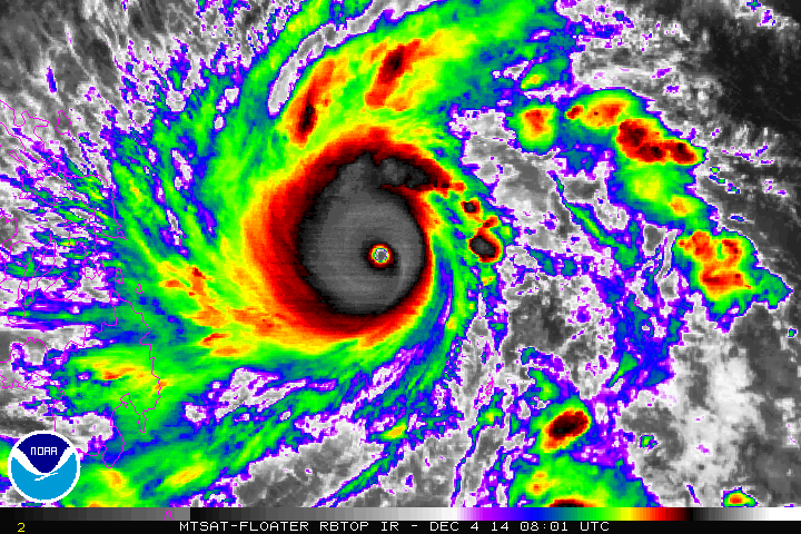
Super typhoon Hagupit (Ruby) satellite image
The Philippines has been evacuating residents from low-lying coastal areas that are in the path of super typhoon Hagupit, as well as cancelling flights into some regions within the dangerous storms path. With a history of devastating typhoons, the Philippines is as prepared as anyone, however the intensity of Hagupit will sadly mean a tragic toll is likely once again.
As with Haiyan, super typhoon Hagupit will again make clear the lack of insurance penetration in the Philippines, so the threat to insurance, reinsurance or ILS markets is not expected to be that great.
The Philippines has been actively discussing sponsoring a catastrophe bond with the World Bank. In fact market sources increasingly suggest that the Philippines had expressed a desire to progress the cat bond issuance to have a deal in force by now, but such a deal is said to have now been delayed into 2015.
We don’t at this stage know what delayed the issuance of a Philippines catastrophe bond, but we have been told by sources that there had been a desire to have a deal completed around the anniversary of Haiyan’s terrible impact at the beginning of November.
Super typhoon Hagupit could have a similarly devastating and tragic impact on the Philippines. The location of any landfall will dictate the extent of economic losses to a degree. For example, should Hagupit make landfall near Luzon and track over the capital Manila as a weakened typhoon the chances of extensive property damage could be much greater. The chances of loss of life are sadly high wherever typhoon Hagupit strikes.
![]() View all of our Artemis Live video interviews and subscribe to our podcast.
View all of our Artemis Live video interviews and subscribe to our podcast.
All of our Artemis Live insurance-linked securities (ILS), catastrophe bonds and reinsurance video content and video interviews can be accessed online.
Our Artemis Live podcast can be subscribed to using the typical podcast services providers, including Apple, Google, Spotify and more.


