


Risk modelling firm AIR Worldwide has reduced its estimate of insurance and reinsurance industry losses caused by hurricane Irma, narrowing the range and dropping the upper end to now forecast somewhere between $32 billion and $50 billion of losses across the U.S. and Caribbean.
 AIR Worldwide said that in the United States insured losses from hurricane Irma will total between $25 billion and $35 billion, while in the Caribbean they will total $7 billion to $15 billion.
Previously, AIR had at first estimated the industry loss from the event at $20 billion to $65 billion including the Caribbean, with the U.S. likely to suffer up to $50 billion of the toll. The estimate was then lowered to $20 billion to $40 billion for the U.S. alone and now the range has narrowed and reduced further, as AIR gains greater certainty in the insurance and reinsurance market impact.
AIR said that it has now sent a team of engineers to the areas impacted by hurricane Irma, so it will release findings in the coming weeks and likely be able to further update and narrow its industry loss estimate range.
AIR’s estimate of industry insured and reinsured losses for the United States include wind and storm surge damage to onshore residential, commercial, and industrial properties and their contents; as well as losses to auto lines of business.
They do not include losses to the National Flood Insurance Program (NFIP); losses due to compromised existing defenses (e.g., natural and man-made levees); losses to uninsured properties; losses to infrastructure; losses to inland marine, marine cargo and hull, and pleasure boats; or any losses related to hazardous waste cleanup, vandalism, or civil commotion, whether directly or indirectly caused by the event.
Across the Caribbean, AIR’s loss estimate includes wind and precipitation-induced flooding damage to onshore residential, commercial, and industrial properties and their contents, auto lines, and time element coverage (additional living expenses for residential properties and business interruption for commercial properties).
AIR’s Caribbean estimates do not include infrastructure losses; hazardous waste cleanup, vandalism, or civil commotion costs whether directly or indirectly caused by the event; demand surge; offshore property losses; pleasure boats, and marine craft; losses resulting from the compromise of existing defenses (e.g., levees); and losses to uninsured properties.
There will be a relatively significant amount of insurance losses to marine and boating lines from hurricane Irma, which may be captured by reinsurance and retrocession arrangements as well, hence it’s important to now what’s in and out of these estimates of market loss.
AIR also explained the impacts caused by hurricane Irma:
![]() View all of our Artemis Live video interviews and subscribe to our podcast.
View all of our Artemis Live video interviews and subscribe to our podcast.
All of our Artemis Live insurance-linked securities (ILS), catastrophe bonds and reinsurance video content and video interviews can be accessed online.
Our Artemis Live podcast can be subscribed to using the typical podcast services providers, including Apple, Google, Spotify and more.
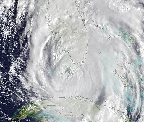
Irma hammered much of Florida on Sunday, September 10, through the next day, with rain and winds that ripped off roofs, downed trees, caused widespread power outages, and flooded towns. Most of Florida was in peril due to the massive size of the storm, as hurricane-force winds extended 80 miles from the eye, and tropical storm–force winds extended more than 400 miles, covering the entire state and driving storm surge into both the Atlantic and Gulf coasts. After making its first landfall in Barbuda at Category 5 strength on September 6, Hurricane Irma left a trail of destruction in the Caribbean, moving north and west across islands such as St. Kitts and Nevis, Anguilla, St. Martin/St. Maarten, St. Barts, and the British and U.S. Virgin Islands. Irma made a second landfall on Cuba’s northern coast as a Category 5 storm on Friday, September 8. The interaction with Cuba’s northern coast weakened Irma to a Category 3 before a trough of low pressure turned Irma northward on Saturday, September 9.
As Irma moved north toward the Florida Keys on Saturday night, it reintensified, making an initial U.S. landfall at 9:10 on Sunday morning on Cudjoe Key at Category 4 strength, with maximum sustained winds of 130 mph. Key West and other islands west of Cudjoe Key in the Florida Keys were spared the very worst of the damage from the hurricane’s right-front quadrant, which had the highest winds and surge potential.
Beginning to be impacted by increasing vertical shear, the storm weakened to Category 3 again before it made a second U.S. landfall on the southwest coast of Florida at Marco Island, just south of Naples, at 3:35 p.m. on Sunday. Maximum sustained winds at landfall were 115 mph, according to the NHC. Miami avoided the direct hit that was feared as Irma had shifted farther west; although the storm still lashed the city with dangerous winds, rain, and storm surge, damage was not as catastrophic as had been expected a couple of days earlier. The relentless storm surge did cause saltwater, sand, and mud to spill onto roads and into the first floors of some businesses and homes.
Irma continued moving north, passing over Naples before weakening to a Category 2. The storm moved inland on Sunday evening, sparing Tampa a direct hit. Overnight, Irma passed west of Orlando, lashing the middle of the state with high winds and torrential rain. Tornado warnings were issued across several central and eastern Florida counties, and at least two tornadoes touched down briefly.
On Monday morning, September 11, Irma—now downgraded to a tropical storm—brought heavy rain and storm surge to Jacksonville on Florida’s northeast coast. As a result of the heavy rainfall that fell in the Jacksonville, Orlando, and other adjoining areas, as well as storm surge preventing water from draining out of the St. John’s River for multiple tidal cycles, many river gauging stations in the National Weather Service Jacksonville Weather Forecast Office region area experienced major flooding stages. Jacksonville saw the worst flooding in the last 60-plus years as the St. Johns River, which flows through its downtown area, was hit by the double whammy of storm surge and high tides on one side and very heavy precipitation and resulting high river flows from its catchment on the other. St. Johns River crested at 5.57 feet, about 1.5 feet higher than its previous record set in 1964. Cedar River at San Juan Avenue in Jacksonville that flows into the St. Johns River also broke its historic flood record set in 2004.
Storm surges in other parts of northern Florida up to coastal South Carolina combined with the high tide that coincides with the full moon to exceed previous records from Hurricane Matthew. A storm surge of 10 feet covered Charleston, S.C., up to a mile inland, flooding downtown, swamping cars, and leaving some residents in waist-deep waters. The storm surge for Savannah, Georgia, and nearby Tybee Island was 4.7 feet, with swells up to 15 feet, covering neighborhoods with deep water.
Across Florida, downed trees, signs, and utility poles and flooded or debris-strewn streets are common, particularly in the southern regions. Wind damage to homes and businesses ranged from moderate to catastrophic. Trees falling on homes, damage to cars, and occasional structure fires have been reported.
Irma’s heavy rain and tropical storm–force winds caused flooding, downed trees, and widespread power outages in Georgia, Alabama, South Carolina, and North Carolina—particularly in coastal areas.


