


The threat posed to European insurers and reinsurers by the peril of European windstorms is once again front of mind as meteorological agencies put out warnings for a deep area of low pressure expected to hit Norther Europe today named European windstorm Xaver.
European windstorm Xaver is a deepening area of low pressure which has been moving over the north Atlantic towards Northern Europe and was given its name by the Free University of Berlin yesterday. Forecasters expect the storm to intensify as it approaches land, bringing with it near hurricane force winds to some parts of Europe.
Weather warnings are currently in force for northern England and Scotland, the Netherlands, Denmark, southern Sweden and Germany, all of which are expected to see strong, potentially damaging winds and a significant storm surge. The approach of European windstorm Xaver coincides with spring high tides, meaning tidal levels are already high and a surge of around 3m above normal is to be expected in some areas.
The UK’s Met Office said to expect wind gusts of as high as 145km per hour in Scotland and northern England. In Northern Germany winds of over 140 km/h are possible and the city of Hamburg is under a threat of storm surge, with tidal levels expected to be 2.5m above normal. The Dutch port of Rotterdam has closed its flood gates for the first time since they were built in the 1990’s, which should give readers an idea of how seriously the threat of surge is being taken.
Dr. Jeff Masters, a meteorologist with the Weather Underground, said in his latest update on Xaver;
“Xaver will be accompanied by intense thunderstorms capable of mixing the stronger winds occurring aloft down to the surface, and wind damage may rival that of October’s Extratropical Storm “Christian” (AKA the St. Jude storm), which bottomed out at 968 mb. Christian killed 18, and did $1.4 billion in damage. There is a smaller chance that the wind damage from Xaver will approach that of Windstorm Anatol, which hit Denmark, Southwest Sweden, and Northern Germany on December 3, 1999. Anatol had sustained winds of up to 91 mph (146 kph), killed 20 people, and injured over 800. Damage was $2.6 billion (1999 dollars) in Denmark, making it the costliest disaster in Danish history.”
The maximum storm surge is expected in Germany and Denmark, according to some forecasters, so the threat to areas such as Hamburg is clear. European windstorm Xaver is expected to move relatively rapidly across Denmark and into Germany, where strong winds will be felt far inland. The German storm surge forecast suggests a 3m surge to hit regions around Cuxhaven early on Friday 6th. You can also find some northern European storm surge forecasts here (in German).
This interesting graphic below shows a forecast for Xaver’s position compared with a storm which struck Hamburg in 1962 causing widespread storm surge flooding. You can clearly see the similarities. Unfortunately we don’t have a source for this image (found online).
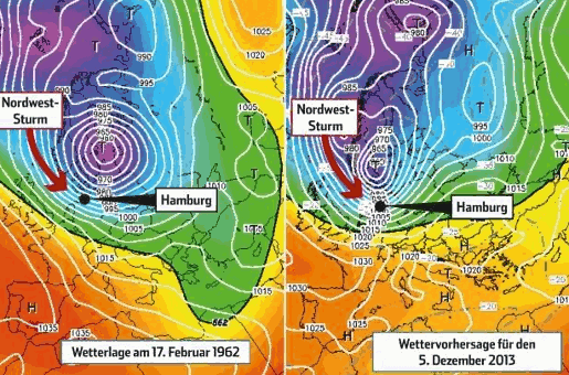
European windstorm Xaver forecast
Forecasters suggest that European windstorm Xaver may continue to strengthen through Thursday and that Germany could see a stronger storm than it did in October with Christian. This forecast is dependent on how much the interaction with land weakens Xaver, so is far from certain right now.
Central pressure for windstorm Xaver is expected to drop right down to around 966mb, which is close to Christian’s minimum central pressure. However, some forecasters believe that Xaver has a greater potential for localised strong wind gusts.
The impact of European windstorm Xaver from storm surge will be largely dependent on the time it arrives in different areas and whether it coincides with the high tides. If it moves faster than expected then tides may not be so high, meaning that sea defences may be sufficient to prevent any flooding. Should it arrive at high tide then there is likely to be some coastal flooding, according to forecasters.
It is not expected at this time that European windstorm Xaver would become a large enough insured loss event to threaten any European windstorm catastrophe bonds, but it could become another loss to hurt European insurers and reinsurers. Should it hit the reinsurers then there will also be the potential for some ILS and collateralized reinsurance managers to be impacted as well.
Even if Xaver does not create a large loss for the insurance industry the storm should serve as another reminder that European windstorm season is here and the threat can be on a par with U.S. hurricanes, making it a peril to watch closely during the winter months.
Update 15:00 GMT, Thursday 5, December:
The UK’s Environment Agency has upgraded its warning to say that the surge threat faced from Xaver is the most severe seen for 60 years in the North Sea. That gives you an idea of the scale of the threat, should Xaver’s storm surge coincide with high tides. The River Thames flood barrier was closed to protect London, a measure that is not taken lightly.
Wind gusts of up to 142mph have been recorded in the Scottish Highlands, with considerable disruption and some damage occurring as a result.
The storm is now beginning to move towards Norther Europe, with forecasters suggesting that winds of up to 90mph should be expected in Denmark, the Netherlands, Belgium and northern Germany.
European windstorm Xaver is said to be strengthening as it heads across the North Sea towards northern Europe. The low pressure center is expected to deepen as it approaches Germany and the greatest concern is for an arrival of the storm near the German north coast at high tide. Hamburg is said to be particularly at risk, with some suggesting the surge could be as high as any since a flood in 1962. It’s worth noting that Hamburg’s flood defences are much more advanced now than they were in 1962.
Simulations made by scientists in Belgium suggest that surge water levels will reach the highest seen in 30 years.
Twitter is a great resource for keeping up to date with breaking news and events and the timeline below features some interesting photo’s and information on European windstorm Xaver’s impacts.
Update 09:30 GMT, Friday 6, December:
Here’s an update from risk modeller AIR Worldwide, recevied late yesterday:
Xaver Slams Scotland, Heading to the Netherlands, Germany, and Denmark: AIR Worldwide
BOSTON, Dec. 5, 2013 – According to catastrophe modeling firm AIR Worldwide, following less than six weeks after Winter Storm Christian, Winter Storm Xaver hit north of Scotland during the overnight hours. Wind gusts of more than 140 mph (225 km/h) were recorded in the Scottish Highlands, and across the northern UK there have been gusts of between 60 and 80 mph (96 and 128 km/h), with 100 mph (160 km/h) gusts recorded in mountain areas. The strongest winds are expected to decrease in strength later today; however, the risk of coastal flooding is expected to increase in the UK, the Netherlands, northern Germany, and Denmark.
An amber wind alert had been issued for northern and central Great Britain, including north and west Scotland, and yellow warnings for much of Great Britain, including London, Northern Ireland, and Wales. The UK’s Environment Agency has issued more than 200 flood alerts across England and Wales. Homes in Yarmouth, England, on the Norfolk coast have been evacuated in anticipation of storm surge, and Glasgow’s central rail station was evacuated after wind-borne debris caused a partial collapse of its glass roof.
Germany, the Netherlands, and Denmark are preparing for Xaver’s arrival. An extreme weather warning has been issued for Germany’s northern states, including Hamburg, Schleswig-Holstein, Lower Saxony, and Bremen. People in northern Germany have been advised to stay indoors. Red warnings, the highest level of weather alerts, have been issued for much of the coastline of the Netherlands. The entire country of Denmark is under orange alert, meaning potential dangerous and unusual weather expected. Weather warnings for southern Sweden are also in force.
“On Wednesday, December 3, a strong surface low developed in the North Atlantic, in an area called the Cold Conveyor Belt,” said Dr. Gerhard Zuba, senior principal scientist, AIR Worldwide. “This extratropical low pressure system strengthened due to a jet stream-induced upper level divergence. As it approached north of Scotland during the overnight hours, Xaver’s central pressure plummeted to 980 mb. A line of severe thunderstorms has developed along a cold front that is traveling across northern Europe today. Risk of tornadoes is possible.”
“Xaver is expected to gain strength today and reach its lowest core pressure of about 960 mb late Thursday afternoon local time over Denmark, where gusts in excess of 140 km/h (97 mph) have already been reported.”
All train service in Scotland was suspended by ScotRail due to equipment damage and debris on the tracks, and up to 100,000 homes in Scotland and about 6,500 in Northern Ireland are without power. The Thames Barrier will be closed this evening local time.
According to AIR, the flood gates protecting Rotterdam have closed for the first time since they were built, in the 1990s, and the Oosterscheldekering in southwest Netherlands is closed for the first time since 2007. Train services in Denmark have been suspended, and several bridges across the country have been closed.
According to the UK’s Environment Agency, storm surge could reach as high as it did during the 1953 North Sea floods, however new flood defenses should reduce the impact. The agency also expects about 3,000 properties to be flooded in the next 24 hours. Flooding has already been reported in north Wales, Northern Ireland, and the west coast of the UK.
Dr. Zuba noted, “Xaver is currently approaching the German coastlines and is expected to bring high winds and coastal flooding. Hamburg is expecting up to three spring tides to occur during Xaver over the next 36 hours, which is moving very slowly. With the actual spring tide expected to be higher than usual already, storm surges of between 1.5 and 2 meters (5 and 6.5 feet) are expected in Hamburg tonight, local time, and between 3 and 3.5 meters (about 10 and 11.5 feet) tomorrow.”
Risk modeller RMS has also published an update on windstorm Xaver:
12/5/2013, Europe – An intense low – Windstorm Xaver – has tracked east to the north of Scotland bringing strong winds and coastal flooding to parts of the U.K. Strong winds and surge from Xaver are forecast to impact the Netherlands, Germany, and Denmark from late UTC, Thursday 5 December.
According to the Met Office, gusts of 60-80 mph (95-130 km/h) were experienced over Scotland and northern England earlier today, with exposed mountain sites registering gusts of well over 100 mph (155 km/h), though this may not be a representative location. Met Office severe weather warnings remain in force for strong winds in the U.K., though the strongest winds are expected to decrease from late Thursday 5 December. However, the risk of coastal flooding is set to increase due to the combination of high tides, strong winds, and storm surge.
As of 17:00 UTC on Thursday 5 December, the Environment Agency (EA) had issued 41 severe flood warnings in the U.K. – the highest warning level – and 125 Flood Warnings – where flooding is expected. The EA state that communities along the North Sea coast from Northumberland down to the Thames Estuary and Kent, in addition to those on the Irish Sea coast from Cumbria down to Cheshire, could see significant coastal flooding later today and into Friday.
The coastline from Wells-next-the-Sea in Norfolk to Clacton, Essex, is particularly at risk, including Great Yarmouth and Lowestoft. According to the EA, the coastal surge along the East Coast of England is expected to be the worst for more than 60 years. According to reports, coastal flooding has already been reported in Rhyl, Denbighshire, Wales, where up to 300 homes have been flooded. Flooding has also been reported in Port Clarence, Middlesbrough, though damage reports remain limited at this time.
Transportation has been severely impacted in Scotland, northern and eastern England, while as of 17:00 UTC, power outages were affecting 68,000 homes in Scotland. The windstorm is forecast to begin impacting the Dutch, German and Danish coasts on the afternoon of Thursday 5 December.
According to the German Weather Service (DWD), winds will reach up to 85 mph (140 km/h) in exposed locations in northeast Germany, with strong gusts continuing further south. The Lower Saxony State Office for Water Management, Coastal Defence and Nature Conservation (NLWKN) has forecast a large storm surge of up to 3.5 meters (11.5 feet) in Cuxhaven and Bremerhaven, in northern Germany, during the high tide cycle early Friday 6 December morning. Flood defenses are being positioned across northern Europe in anticipation of the significant storm surge.
RMS is continuing to monitor Windstorm Xaver and will update this Cat Activity on the morning of Friday, 6 December.
Update 14:15 GMT, Friday 6, December:
RMS has updated its catastrophe information on windstorm Xaver.
![]() View all of our Artemis Live video interviews and subscribe to our podcast.
View all of our Artemis Live video interviews and subscribe to our podcast.
All of our Artemis Live insurance-linked securities (ILS), catastrophe bonds and reinsurance video content and video interviews can be accessed online.
Our Artemis Live podcast can be subscribed to using the typical podcast services providers, including Apple, Google, Spotify and more.
12/6/2013, Europe – Windstorm Xaver has brought strong winds and significant surge to parts of northern Europe. However, so far it appears most sea defenses have held, and coastal flooding has not been as severe as forecast. ***UK*** In the UK, Windstorm Xaver impacted Northern Ireland, Scotland and northern England with strong winds on Thursday 6 December.
It has been reported that sustained winds of 40-50 mph (65-80 km/h) were common in these regions. According to reports gusts reached as high as 142 mph (228 km/h) in Aonach Mor ski resort, Scotland early on Thursday. Early reports of damage from wind include uprooted trees, downed power lines and toppled lorries. Reports suggest that more than 130,000 homes were left without power across Britain, the majority of them in Scotland as a result of Xaver.
On Thursday 5 December, the Environment Agency had warned of the most serious coastal tidal surge for over 60 years in England – but it appears that sea defenses have largely held. Despite this, numerous homes are reported to have been flooded. Current reports of coastal flood-affected properties include; 400 in the Humber region; 400 in Rhyl, north Wales; and 100-200 in Whitby, North Yorkshire. In Norfolk, 9,000 people were evacuated from their homes, mainly in the Great Yarmouth area, and at least 26 properties have been flooded.
Surge-damaged homes have also been reported in Hemsby, Norfolk, and Boston Lincolnshire – where a sea defense was breached. Reports suggest that flood waters in these areas are beginning to recede but there will be further high tides later on Friday 6 December. On Thursday 6 December, North Sea oil and gas producers including ConocoPhillips, Maersk Oil, and Statoil cut production and evacuated staff from some platforms.
***Rest of Europe*** Strong winds from Windstorm Xaver began impacting mainland, northern Europe on the afternoon of Thursday 5 December. Severe levels of surge were expected across coastal portions of Germany, Belgium, the Netherlands and Denmark, with the potential impacts particularly large in Hamburg, Germany. However here too it appears sea defenses have largely held, preventing major impacts.
In the north of Germany, according to the German Weather Service (DWD), widespread gusts of over 65 mph (100 km) were experienced, with gusts of up to 55 mph (90 km) measured further inland. The town of Glücksburg, located near the Danish border, experienced peak gusts of up to 100 mph (158 km/h) – the strongest in Germany according to DWD. In the port city of Hamburg, the surge height reached 6.09 m (20 ft) above sea level by 06:30 – but defenses have prevented severe flooding, with part of the port and the fish market reported to have been affected. However, storm surge risk remains with the next high tide expected at around 19:00 today.
Elsewhere, it has been reported that streets in the German town of Sylt have been inundated by surge. In Belgium, a storm surge height of up to 6.44 meters was recorded and 2,000 people were preemptively evacuated from the coastal town of Bredene. However, at this time, no major damage has been reported. Officials have also stated that winds were lower than expected. To date, it appears that damage has been minimal in the Netherlands and Denmark too, with transport, rather than property the worst affected. In Poland, it has been reported that power outages have hit 100,000 households. Transport has been affected across northern Europe, with rail and air travel impacted. As of early Thursday 5 December, Xaver had moved to the Baltic States while weakening, with wind speeds having reduced significantly.


