


Long-range weather forecast model runs show a chance of Atlantic tropical systems forming in the next fortnight, with some being given as much as a 60% chance of becoming a named storm, while another has a lower probability being further out, but if it transpires it could be more impactful to insurance and reinsurance.
The first are three forecasted tropical waves that are expected to develop off the west coast of Africa, of which two are being given a greater than 60% chance of forming into named tropical storm Florence in around two to four days time, while another model and NOAA’s National Hurricane Center puts that at a 50% chance. These waves are not expected to pose a major landfall threat at this time.
The second scenario and likely to be more immediately concerning should it occur, is a forecast model run showing a tropical system forming near the southeastern corner of the United States, which would become named tropical storm Gordon if the forecast is accurate.
This second possible scenario for a future named storm is given a lower probability of occurring in the next roughly 7 to 10 days currently, at 10% to 30%. But the forecast models show this potential storm as a threat to the south-east including Florida and the Gulf Coast region, as model runs show this system potentially forming around the Bahamas, crossing from the Atlantic into Florida and running into the Gulf of Mexico.
The forecasts that we’ve seen come from the Climate Forecast Applications Network (CFAN) extended range 14 day TropiCast, which looks at ECMWF and GEFS forecast model runs and applies CFAN’s own insights to them, deriving a CFAN forecast for tropical activity.
CFAN gives some probabilities for different intensities of hurricanes to form in the various tropical regions of the Atlantic, Caribbean and Gulf.
For the Atlantic’s Main Development Region, CFAN’s analysis shows that days forward 3 to 14 have a 60% or greater likelihood of there being a Category 1 or 2 hurricane spinning in the region on any day in that range. But Days 4 to 5 and 12 to 13 of this particular forecast indicate a greater than 30% chance of a Category 3 or higher hurricane in that region on those specific days.
But the chances of any main development region activity making landfall in the United States are given as remote at this time, with only a few ensemble runs showing this outcome.
The Gulf of Mexico shows the chances of hurricane activity in the next fortnight as lower, but the greatest chance is given to Days 7 to 10 in the ECMWF forecast, when there is considered to be a roughly 30% chance of a low category hurricane spinning up in the Gulf, with a 10% or greater chance of a major hurricane. The GEFS highlights Days 11 to 13 with a 30% or greater chance of hurricane activity in the Gulf.
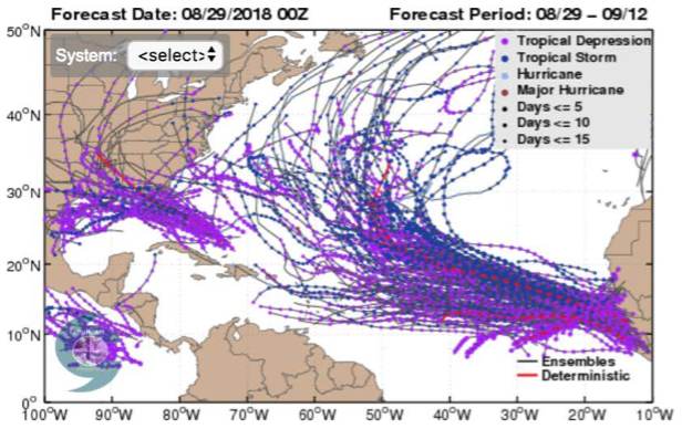
Forecast tropical storm and hurricane tracks from ECMWF ensmbles analysed by CFAN (14 Days out from 29th August)
With numerous tropical waves expected to form off Africa it seems the steering winds and currents are expected to propel these northwards in the Atlantic, rather than towards the U.S. Of course this can always put Bermuda in the frame, so something to watch out for potentially.
Beyond the 14 day forecast window CFAN still sees a chance of above average activity near the southeast United States.
For insurance, reinsurance and insurance-linked securities (ILS) interests, these forecasts suggest a watchful eye is kept on the tropics over the coming week or so, which with the market now ramping up its preparations for the 2018 Monte Carlo Reinsurance Rendez-vous is certain to keep companies on their toes.
Of course there is no guarantee that any of these forecast scenarios play out, conditions in the tropics can change. But other meteorologists we track have been warning of a heightened risk of tropical activity in the main development region and also closer into the U.S. southeast for some days now, suggesting that CFAN’s predictions are aligned with other eminent forecasters.
Any signals of a heightened chance of hurricane activity at this time of year, considered the start of the peak season, should be taken notice of and watched closely by insurance, reinsurance, ILS and catastrophe bond interests.
Keep track of our 2018 Atlantic Hurricane Season page where we will update you on any tropical storms that form and hold a threat to insurance or reinsurance interests over the coming months.
![]() View all of our Artemis Live video interviews and subscribe to our podcast.
View all of our Artemis Live video interviews and subscribe to our podcast.
All of our Artemis Live insurance-linked securities (ILS), catastrophe bonds and reinsurance video content and video interviews can be accessed online.
Our Artemis Live podcast can be subscribed to using the typical podcast services providers, including Apple, Google, Spotify and more.


