


The early forecasts and outlooks for the 2016 Atlantic tropical storm and hurricane season seem to suggest a possible return towards more average conditions, with a 97% landfall probability for the U.S. coastline, as the current El Niño impacts may wane.
For the insurance and reinsurance industry, the insurance-linked securities (ILS) fund managers and their investors, as well as investors in catastrophe bonds, the outlook for the Atlantic hurricane season is one of the most important forecasts of the year.
At this early stage, the outlooks and forecasts come with little certainty. With a strong El Niño in the Pacific currently, which some climate researchers and meteorologists believe to have peaked, the question now is how will it influence the Atlantic tropics in 2016 and how quickly will conditions shift to La Niña?
With the cat bond market so exposed to U.S. hurricane risks and Florida and the U.S. coastline still a driver of reinsurance market profits, in quieter years, the seasonal outlook is key.
The Colorado State University Dept of Atmospheric Science tropical storm and hurricane forecast team of Klotzbach and Gray only provide a qualitative outlook this far out from the 2016 hurricane season, but as ever their opinion on the activity that will be seen is important to consider.
The Colorado State forecasters assess potential 2016 Atlantic hurricane activity based on two factors, the strength of the Atlantic Multi-Decadal Oscillation (AMO) and thermohaline circulation (THC) and the phase of ENSO.
They give the greatest chance, at 35%, that in 2016 the AMO/THC is above average and some El Niño impacts remain, resulting in a seasonal average Accumulated Cyclone Energy (ACE) of 120.
That would indicate a 2016 hurricane season with around 12-15 named storms, 6-8 hurricanes and 2-3 major hurricanes, which is an average year typically.
However the Colorado State team give the 2nd highest chance, at 25%, that AMO/THC becomes above average in 2016 and El Niño conditions dissipate, resulting in ACE of 170 for the 2016 hurricane season.
A 170 ACE season would be above average, indicating a chance of 14-17 named storms, 9-11 hurricanes and 4-5 major hurricanes.
One forecast data point that the Colorado team do provide is climatological landfall probabilities.
They give a 97% chance that a named storm makes landfall in the U.S., an 84% chance of a hurricane striking and a 52% chance of a major hurricane hitting the U.S. at some point during the 2016 season.
Florida and the East Coast gets a named storm landfall probability of 81%, the Gulf Coast 83%. Florida and the East Coast’s hurricane landfall probability is 61% in 2016, the Gulf Coast 60% and for major hurricanes the forecasters suggest a 31% probability that Florida and the East Coast is hit by a Category 3, 4 or 5 hurricane and the Gulf Coast 30%. Florida alone has a 51% probability of a hurricane strike in 2016 and a 21% probability of a major hurricane landfall.
These numbers suggest an average season, but it would not take much to see an above average season and a huge amount of uncertainty remains due to ENSO conditions and how they will be affecting the Atlantic in 2016. The Colorado team’s first official forecast is due next April.
On landfalling storms and hurricanes the Colorado State researchers put a lot of the recent drought down to climatological luck, essentially.
“This luck cannot continue. Climatology will eventually reassert itself with many more US landfalling hurricanes. Coastal residents must realize that hurricanes remain a serious threat and should take preparedness actions before every season,” they wrote.
The researchers explain that “anomalous troughing” over the northeast U.S., low pressure systems, has influenced westward tracking storms and steered them to recurve away from the U.S. This set up cannot last forever.
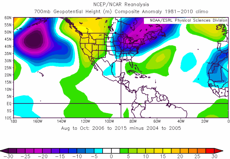
August-October 700-mb heights averaged from 2006-2015 minus August- Occtober 700-mb heights averaged from 2004-2005. Note the anomalous low pressure along the East Coast of the United States
The other early forecast is from Tropical Storm Risk, who predict that the 2016 hurricane season will see activity 20% below the long-term average. However they highlight the uncertainty in this forecast at this far out from the 2016 season itself.
“Based on current and projected climate signals, Atlantic basin tropical cyclone activity is forecast to be about 20% below the 1950-2015 long-term norm and about 15% below the recent 2006-2015 10-year norm,” TSR explain.
TSR uses as its main predictor the forecast July-September trade wind speeds over the Caribbean Sea and tropical North Atlantic, which influence cyclonic vorticity (the spinning up of storms) as well as vertical wind shear, which can tear storms apart, in the main hurricane track region of the Atlantic.
TSR believes the trade wind and SST predictor will have a near-neutral effect on activity, but notes that its forecasts in December typically have low accuracy, given how far in advance they are.
TSR forecasts ACE of just 79 for the 2016 season, which would indicate 13 named tropical storms, 5 hurricanes and 2 major hurricanes would form.
That’s actually above average for the formation of named storms, but slightly under for hurricanes and major hurricanes.
For the reinsurance community and also catastrophe bond investors, while major hurricanes are the largest threat named storms are becoming more impactful due to the changes in coverage offered to aggregate and also expanded terms on hours clause and storm definitions. Hence an above average number of named storms, combined with higher landfall probabilities, could still be impactful.
TSR says there is a 25% probability that 2016 Atlantic hurricane season ACE will be above-average, a 34% likelihood it will be near-normal and a 41% chance it will be below-normal.
TSR does not however give any forecast or outlook for steering winds and landfall probabilities for the 2016 hurricane season at this stage.
So overall the forecasts look like a near average year in terms of storms, but a chance of more named tropical storms than the long-term trend and perhaps a higher than normal chance of landfall in the U.S. as El Niño’s influence on tropical storm steering wanes in 2016.
It won’t be until the April 2016 forecasts that we will get more certainty on the outlook, even then conditions can change and steering jet stream winds can impact the direction of storms much nearer the season.
We will update you as and when new forecast information emerges.
You can download the Colorado State outlook for 2016 Atlantic tropical activity here and the Tropical Storm Risk long-range forecast here (both in PDF format).
![]() View all of our Artemis Live video interviews and subscribe to our podcast.
View all of our Artemis Live video interviews and subscribe to our podcast.
All of our Artemis Live insurance-linked securities (ILS), catastrophe bonds and reinsurance video content and video interviews can be accessed online.
Our Artemis Live podcast can be subscribed to using the typical podcast services providers, including Apple, Google, Spotify and more.


