


Category 4 Typhoon Chan-hom is barreling towards the China coast, targeting a landfall somewhere to the south of Shanghai. Chan-hom looks set to be among the strongest typhoon’s ever to strike that area of the country, with its storm surge potential looking ominous.
Following hot on the heels of Linfa, which made landfall yesterday soaking a region to the south of Chan-hom’s destination on the Chinese coast, Chan-hom is a considerably larger and more powerful typhoon posing a greater threat to the insurance and reinsurance industry.
Currently, Chan-hom is a Category 3 or 4 level typhoon, with sustained winds of 126mph and much higher gusts of 155mph plus. Size wise, Chan-hom has become a monster typhoon, spanning a huge area and threatening to impact a large swathe of China’s coastline to the south of Shanghai.
The forecast models show a consensus that the eye of typhoon Chan-hom will come ashore to the north of Wenling in Zhejiang province, perhaps as close to Shanghai as only 150 miles south. Shanghai typhoon impacts are considered a major peril in the insurance and reinsurance market, given it has among the highest levels of insurance penetration in China and a significant sized industrial sector in the region.
Any deviation further north will bring the landfall nearer to Shanghai, increasing the threat to the city and surrounding area as well as the height of the storm surge.
Typhoon Chan-hom forecast path or track, taking the storm very close to Shanghai - Source: Weather Underground
You can clearly see the scale of typhoon Chan-hom and its well-defined eye in the satellite image below.
Typhoon Chan-Hom satellite image - Source: Weather Underground
Chan-hom is expected to weaken as it approaches the Chinese coastline, perhaps down to a Category 2 or strong Category 1 typhoon, according to the current forecasts. That would put its sustained winds around 90mph to 100mph, with higher gusts, sufficient to cause damage to property and infrastructure in the region around landfall.
Following landfall the storm is currently forecast to track almost directly over Shanghai itself, with the forecast currently suggesting that this could be one of the strongest typhoon impacts to Shanghai in years.
As a result and due to the scale of Chan-hom, there is some growing concern about the potential for storm surge to the coastal region where the typhoon makes landfall, but also to Shanghai itself. The Chinese government has evacuated thousands from coastal areas due to the fears over wind and surge damage.
Meteorologist Jeff Masters noted that typhoon Chan-hom has the potential to bring some of the highest water levels ever recorded to Shanghai, particularly if the storm surge coincided with the high tide.
Shanghai is well protected, with a storm surge barrier supposed to protect against a 1 in 1000 year surge event, but even this is considered only just enough if Chan-hom became a worst case scenario.
Masters explained in this article:
A storm of this magnitude is sure to pile up a large storm surge, particularly since Chan-hom is a very large typhoon with tropical-storm force winds that extended outwards 310 miles from the center. This storm surge will pile up throughout the Yellow Sea, from China to the Korean Peninsula. Since the Yellow Sea is shallow and enclosed on three sides, the potential exists for some of the highest water levels ever recorded along portions of the coast south of Shanghai, to the right of where the center makes landfall.
The newly raised floodwalls of Shanghai may see their highest water levels in history when Chan-hom makes landfall, depending upon whether or not the peak storm surge occurs near high tide.
The European Commission Joint Research Centre (JRC) forecasts a storm surge of as high as 3.9 metres in some areas, widely above 3 metres around the coast running up to Shanghai itself. The JRC has issued a red alert for storm surge as a result.
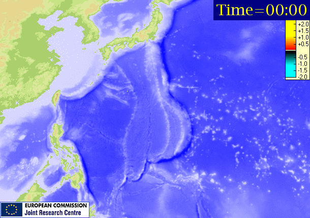
JRC red alert storm surge potential animation for typhoon Chan-hom
Other models are showing a much higher 20 foot plus storm surge to the south of Shanghai and 15 to 20 foot surge to the north. Shanghai’s flood barriers are said to be 22.6 foot high protecting the downtown area, which is why this storm has raised concerns.
How close to Shanghai typhoon Chan-hom makes landfall and how powerful the storm remains will have a huge bearing on the height of the storm surge for the city to endure. Areas of the coast between the landfall and Shanghai, which do not have such floodwalls, could find themselves inundated if the storm surge is as high as predicted and coastal damage may be seen much further into the Yellow Sea.
For the Chinese insurance industry typhoon Chan-hom could pose a reasonable sized loss, given the penetration of insurance is much higher in the Shanghai region than perhaps anywhere else in China. As a result reinsurance industry exposure to Chan-hom is perhaps higher than to the many typhoons that more typically make landfall much further south and west along the coast.
Aon Benfield’s Impact Forecasting unit explained the local insurance industry loss threat as ‘medium’ in its latest update:
LATEST DETAILS ON TYPHOON CHAN-HOM
COORDINATES: 25.6° north, 125.5° east (previous location: 22.5° north, 129.7° east)
LOCATION: 250 kilometers (155 miles) west-southwest of Kadena Air Base, Japan
MOVEMENT: west-northwest at 20 kph (13 mph) (previous: northwest at 22 kph (14 mph))
WINDS: 220 kph (140 mph) with gusts to 270 kph (165 mph) (previous: 170 kph (105 mph))
RADIUS OF TROPICAL STORM-FORCE WINDS: 520 kilometers (320 miles)
RADIUS OF HURRICANE-FORCE WINDS: 120 kilometers (75 miles)
MINIMUM SEA LEVEL PRESSURE: 933 millibars (previous: 956 millibars)
SAFFIR-SIMPSON SCALE RANKING*: Category 4
LANDFALL AND LOSS PROBABILITIESFORECAST LANDFALL LOCATION: Near Taizhou, Zhejiang Province, China
FORECAST LANDFALL TIMEFRAME: Saturday afternoon local time (CST)
24-HOUR SIGNIFICANT LOCAL INSURED LOSS POTENTIAL: MEDIUM
DISCUSSIONTyphoon Chan-hom, located approximately 250 kilometers (155 miles) west-southwest of Kadena Air Base, Japan, has tracked west-northwestward at 20 kph (13 mph) over the past six hours. High resolution, animated satellite imagery shows vigorous feeder bands wrapping into a well-defined 28-kilometer (17-mile) wide eye. The current position is based on the eye feature with high confidence. The current intensity estimate of 220 kph (140 mph) is based on the structure of the system and is hedged slightly higher than the corresponding Dvorak current intensity estimates from all reporting agencies. Upper level analysis indicates that Chan-hom is located in an area of favorable vertical wind shear and good outflow aloft. The typhoon is tracking along the southwestern edge of a deep-layered high pressure ridge to the north.
Chan-hom is forecast to continue tracking northwestward under the steering influence of the aforementioned high pressure ridge through the next 24 hours. Favorable environmental conditions will persist, maintaining the current intensity in the short term. After 24 hours, unfavorable environmental conditions will start the weakening trend of Chan-hom. By Saturday afternoon (local time), the system will further weaken as it tracks over eastern China. At the same time, an approaching mid-latitude trough will pass to the north, weakening the high pressure ridge and allowing the typhoon to track poleward. By Monday morning (local time), the high pressure ridge is expected to reorient and will drive the system northeastward.
Chan-hom will maintain a northeastward track through the end of the forecast period. With the exception of one forecast model, which takes the system inland, the majority of the forecast models assessed are in overall good agreement emerging the system into the southern portion of the Yellow Sea. Due to the spread in model guidance in the extended forecast however, the JTWC track confidence level remains low.
Typhoon Chan-hom is expected to make landfall on Saturday around mid-afternoon local time. We’ll update this article if more details of pre-landfall forecasts become available later today.
![]() View all of our Artemis Live video interviews and subscribe to our podcast.
View all of our Artemis Live video interviews and subscribe to our podcast.
All of our Artemis Live insurance-linked securities (ILS), catastrophe bonds and reinsurance video content and video interviews can be accessed online.
Our Artemis Live podcast can be subscribed to using the typical podcast services providers, including Apple, Google, Spotify and more.


