


The first major threat to Japan from the typhoon season is developing as a typhoon named Neoguri (or typhoon 08W or typhoon 1408) has intensified to super typhoon status, with maximum sustained winds of over 150 mph and further strengthening forecast.
Super typhoon Neoguri is currently forecast to pass slightly to the west of Okinawa following which it is forecast to turn towards the north-east and head towards Kyushu, the southernmost of the main Japanese islands. The current forecast could take Neoguri close to Japanese cities such as Nagasaki, areas with sufficient concentration of insurable value to concern insurers and reinsurers.
The impact and eventual insured losses caused by super typhoon Neoguri will come down to its path and how much intensity it can maintain after having crossed the islands around Okinawa. Current forecasts suggest that Neoguri could have sustained winds of near 170 mph when it approaches Okinawa with higher gusts, followed by some weakening but Neoguri could still impact Kyushu with sustained winds of as much as 125 mph according to the forecast. As the graphic below (from CNN) shows even when Neoguri makes it to the middle of Japan, nearest to Tokyo, it could still have sustained winds of 90 mph (see the bottom of this article for a live, updated tracking map).
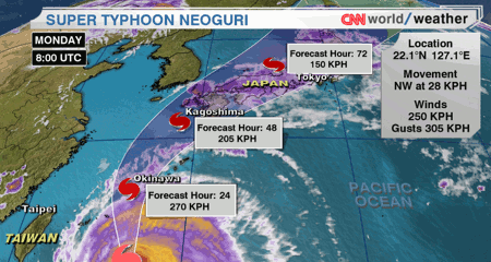
Super typhoon Neoguri forecast path or track
Super typhoon Neoguri has a very defined eye structure and the appearance of the storm from satellite images (a recent one can be seen below) makes it look set for further intensification.
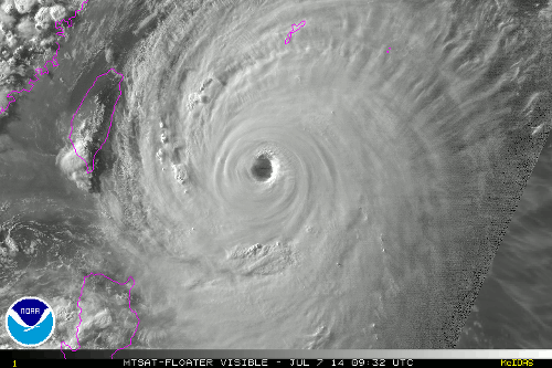
Super typhoon Neoguri satellite image
The forecast shows super typhoon Neoguri hitting Kyushu as a Category 3 storm, then moving up the main Japanese island of Honshu as a strong Category 1 typhoon. Storm surge, flooding from extreme rainfall, as well as wind damage is possible along the typhoons route.
Neoguri could be the most powerful typhoon to come close to Okinawa in more than 15 years. The storm is not expected to make a direct hit, rather passing to the west, but that does put the most powerful winds on the right hand side of the storm closer to Okinawa.
Storm surge from Neoguri could be devastating in the Ryukyu islands and Okinawa with some forecasts suggesting it could reach 6 metres (20 feet). A storm surge is expected along the southern and western coasts of Kyushu, with Nagasaki and Kagoshima cities the most at risk.
Localised rainfall totals of as much as 15 inches are expected which could cause severe flooding along the typhoons path.
Tokyo and other more northern cities in Japan on Honshu are expected to escape the worst from Neoguri, with rainfall and coastal flooding the worst effects likely to be felt or to cause damage. Wind speeds will likely be too low for any major damage in these large metro areas of central Japan by the time Neoguri reaches them later this week.
The reinsurance market could well feel an impact from super typhoon Neoguri as the storm has the potential to cause significant damage in Okinawa and also Kyushu. The location of its approach to Kyushu will dictate the extent of any damage to a degree. If Neoguri slams straight into Nagasaki, for example, the potential for insured losses will be much greater.
Three catastrophe bonds are exposed to Japan typhoon currently. Aozora Re Ltd. (Series 2014-1), an approximately $100m deal protecting Sompo Japan and Nipponkoa Insurance Company from Japan typhoon losses on an indemnity basis. Akibare II Ltd. is a $130m cat bond protecting Mitsui Sumitomo Insurance Co. Ltd. from wind and flood losses from Japan typhoon on a modelled loss trigger basis. Finally, Kizuna Re Ltd., a $160m cat bond protects Tokio Marine from Japanese typhoon losses.
While these three catastrophe bonds are all exposed to super typhoon Neoguri the chance of it causing a loss to them are likely slim. Most Japan typhoon cat bonds have their risk focused around the major Japanese cities of Tokyo, Kyoto, Osaka etc, protecting them from a more direct typhoon impact to that middle region of Japan. It would take something exceptional from Neoguri to cause a loss to the Aozora Re and Kizuna Re cat bonds indemnity triggers, we believe.
Akibare II is a little more of an unknown as it uses a modelled loss trigger, it’s very difficult to predict how such a cat bond will respond under catastrophe conditions without access to the model data. However at the moment, unless Neoguri maintains its strength for longer as it approaches Kyushu and strikes a Japanese city more directly it remains hard to see how such a storm could trigger it.
Reinsurers could well face losses from Neoguri though and that does mean that some collateralized reinsurance providers, or ILS funds participating in Japanese reinsurance programs on private terms, could be exposed. Whether there is any impact to these capital providers will depend on the eventual industry loss.
Super typhoon Neoguri tracking map:
The tracking map below will be updated as typhoon Neoguri continues its approach towards Japan.
![]() View all of our Artemis Live video interviews and subscribe to our podcast.
View all of our Artemis Live video interviews and subscribe to our podcast.
All of our Artemis Live insurance-linked securities (ILS), catastrophe bonds and reinsurance video content and video interviews can be accessed online.
Our Artemis Live podcast can be subscribed to using the typical podcast services providers, including Apple, Google, Spotify and more.
Super typhoon Neoguri tracking map (updated regularly) from the Weather Underground


