


Arthur, the first named storm of the 2014 Atlantic tropical storm and hurricane season, has now reached Category 1 hurricane status, with maximum sustained winds currently around 75 mph but further strengthening possible.
Update 08.00 GMT Friday July 4th:
Hurricane Arthur is now a category 2 storm with maximum sustained winds of 100 mph and minimum central pressure has dropped again to 973mb. Arthur has made landfall around the Outer Banks and Hatteras area and is battering the region. The eye of Arthur is currently moving through Pamlico Sound while hurricane conditions are spreading along the Outer Banks.
Update 23:00 GMT: Hurricane Arthur has intensified further to a storm with 90 mph sustained winds and minimum central pressure of 977mb. Further intensification is forecast before Arthur makes landfall on the North Carolina Outer Banks, and Arthur could be Category 2 storm with 100 mph sustained winds when it strikes land.
Update 14.00 GMT: Hurricane Arthur’s maximum sustained winds have now risen to 80 mph and the minimum central pressure has dropped to 983mb. Further strengthening is still expected prior to landfall, or the hurricanes closest brush with North Carolina (depending on track) late tonight. Still the models converge on hurricane Arthur brushing the Outer Banks and Cape Hatteras, but some continue to show the storm coming ashore more directly to the west of that area.
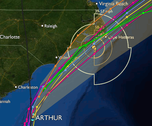
Original article: Hurricane Arthur is currently situated about 190 miles south south-west from Cape Fear, North Carolina and is expected to take a north-eastward track coming close to the Carolina Outer Banks area late tonight (eastern time). The minimum central pressure of hurricane Arthur has dropped to 985mb.
Further strengthening of hurricane Arthur is forecast, with the latest from the NOAA suggesting Arthur will be a strong Category 1 or maybe even weak Category 2 hurricane with sustained winds of 85 mph by the time it approaches the coast.
There is some uncertainty still among forecast models as to exactly how close to the coast hurricane Arthur will get. Most of the forecast models show Arthur brushing the Outer Banks, while one show the eye of hurricane Arthur coming ashore closer to Wilmington, NC.
Hurricane Arthur forecast models
The eventual landfall location of hurricane Arthur will greatly influence the potential for losses from wind damage. Depending on landfall location Arthur could cause some damage to properties, particularly weaker structures and at 85 mph sustained winds will be enough to concern some insurers and reinsurers.
Storm surge is the other threat from hurricane Arthur. Currently the NOAA is forecasting a storm surge of between 2 and 4 foot, to be accompanied by damaging waves. Rainfall amounts of up to 6 inches locally are also possible, which could result in some flood threat while isolated tornadoes are also possible along the North Carolina coast.
Once past the outer banks hurricane Arthur is forecast to accelerate north eastwards and begin to weaken as it approaches parts of the Canadian coastal areas and becomes extratropical.

Hurricane Arthur forecast path and track - From the NOAA
In terms of the catastrophe bond market, a number of transactions are clearly exposed to North Carolina hurricane impacts, in particular Tar Heel Re Ltd. (Series 2013-1) which provides North Carolina wind pools the North Carolina Joint Underwriters Assn. (NCJUA) and the North Carolina Insurance Underwriters Assn. (NCIUA) with a source of hurricane reinsurance protection.
An indemnity transaction, Tar Heel Re has an attachment point at $2.025 billion of losses to the wind pools, so would require a quite significant industry loss event to occur in order for them to take that share of losses. That’s not to say it’s impossible from a storm like Arthur, but it would need to take a quite exceptional track ashore to impact sufficient insurable value to cause that level of loss. Alternatively the storm would need to intensify significantly to worry investors in Tar Heel Re.
There are many other U.S. wind exposed catastrophe bonds with exposure to hurricanes impacting North Carolina but at this time Arthur does not look to be severe enough to concern any of them. For collateralized reinsurance there could also be an exposure through large reinsurance programs covering the region, but still while Arthur remains a Category 1 storm and the track aims for the Outer Banks area, exposure will likely be limited.
Hurricane Arthur provides the first test of the season for the catastrophe bond and reinsurance market. We understand that some speculative trades have been proposed in the secondary market but at this time are unlikely to find counterparts as the current forecast does not warrant marking down any North Carolina hurricane exposed cat bonds significantly enough to heighten liquidity.
We’ll update you further should Arthur intensify significantly or the forecast track change dramatically. You can keep up to date by visiting our 2014 Atlantic hurricane season page.
![]() View all of our Artemis Live video interviews and subscribe to our podcast.
View all of our Artemis Live video interviews and subscribe to our podcast.
All of our Artemis Live insurance-linked securities (ILS), catastrophe bonds and reinsurance video content and video interviews can be accessed online.
Our Artemis Live podcast can be subscribed to using the typical podcast services providers, including Apple, Google, Spotify and more.


