Hurricane Bud, the first Pacific hurricane of the season to threaten landfall on the Mexican coast has strengthened considerably into a Category 3 hurricane with maximum sustained winds of 115mph and a minimum central pressure of 960mb. The forecast path for hurricane Bud has changed since we wrote about the storm yesterday when forecasters said it would recurve off the coast but now it is forecast to make landfall directly on the Mexican coastline late Friday as a slightly weakened Category 1 storm. For latest updates updates see foot of article.
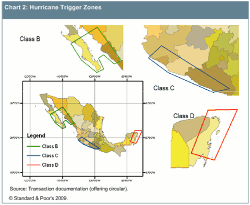
Looking at the available forecasts it still seems unlikely that hurricane Bud will pose any threat to the Class C notes of the MultiCat Mexico 2009 catastrophe bond. It is unlikely that Bud’s minimum central pressure would drop to 944mb or below, the parametric trigger point that is required for the Class C notes to be triggered. Also, the forecast path currently shows hurricane Bud making landfall just outside of MultiCat mexico’s Class C notes trigger zone, you can see this in the two maps below.
As ever with a hurricane approaching land there is uncertainty. In the past we’ve seen hurricanes grow in strength and power just before making landfall as they pass over shallower, warmer seas and it’s also not unknown for a hurricane track to deviate considerably prior to making landfall. At the moment though forecasters and modellers we’ve spoken to say they feel MultiCat Mexico will be safe from this storm. Of course this is still a dangerous hurricane and is likely to cause damage and losses in the areas it impacts from high winds and flooding. We will update you here later today on this post should that sentiment change as hurricane Bud approaches the Mexican coastline.
Hurricane Bud forecast path:

Hurricane Bud forecast path
The MultiCat Mexico 2009 catastrophe bond hurricane trigger zones:

MultiCat Mexico 2009 hurricane trigger zones
Update 1:
In the National Hurricane Centers 9am UTC update they have recorded a slight weakening of hurricane Bud. Maximum sustained winds have dropped slightly to 100mph and the minimum central pressure has risen to 964mb, this recategorised Bud to a Category 2 hurricane. The forecast path remains the same as you can see in the map above. We’ll update you again when the NHC next advise on hurricane Bud.
Update 2:
In the NHC’s 3pm UTC update they say that hurricane Bud’s sustained winds have dropped further down to 100mph and the minimum central pressure has again risen up to 975mb. This is typical of a weakening storm and it now seems near impossible for this to cause any impact to the MultiCat Mexico 2009 catastrophe bond.
 View all of our Artemis Live video interviews and subscribe to our podcast.
All of our Artemis Live insurance-linked securities (ILS), catastrophe bonds and reinsurance video content and video interviews can be accessed online.
Our Artemis Live podcast can be subscribed to using the typical podcast services providers, including Apple, Google, Spotify and more.


